Ataliva

Last updated
Ataliva
Commune
Ataliva Montaje (2).jpg
Clockwise, from top: Plaza 25 de Mayo, Commune of Ataliva, San Roque Church, the Italian Society, an aerial view of Ataliva, Centennial Monument
Comuna de Ataliva.jpg
The commune of Ataliva in the Castellanos Department
Coordinates: 30°59′00″S61°27′00″W / 30.98333°S 61.45000°W / -30.98333; -61.45000
CountryFlag of Argentina.svg  Argentina
Province Santa Fe
Department Castellanos
Government
   Presidente comunal Fabio César Sánchez
Area
  Total155 km2 (60 sq mi)
Elevation
89 m (292 ft)
Population
 (2010)
  Total2,065
  Density13.32/km2 (34.5/sq mi)
Time zone UTC−03:00
Postal code
S2307
Area code 03493

Ataliva is a town in the department of Castellanos in the province of Santa Fe, Argentina. Founded at the end of the 19th century, it maintains some of the characteristics of the rest of the colonies: it is from the beginning a purely agricultural colony, with a population coming from a mostly Italian immigration process. [1] It is the tenth most populated town in the Castellanos department; and the 106th in the province of Santa Fe. In 2010 it had a population of approximately 2100 inhabitants.

Contents

Ataliva was founded by the San Miguel de Tucumán native Ataliva Roca in 1884 in the area of the old railroad station. Since it was not in a good location due to the constant presence of quarrelsome gauchos, it was moved one kilometre to its present site.

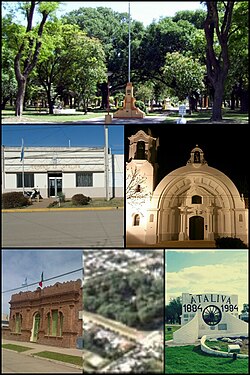
Its urban physiognomy is characterized by an architecture of low houses, where wide streets, avenues and sidewalks with a leafy vegetation of trees of different species stand out.

As for its economy, agricultural and livestock activities stand out, since most of the rural population is dedicated to them.

The town of Ataliva is also known as the "chorizo capital", due to the production of handmade chorizo sausages.

Geography

Location

It is located in South America, at 31° south latitude and 61° west longitude in the center west of the province of Santa Fe. Located on provincial routes 13 and 62 S, and 5 km from National Route 34, Ataliva is 107 km from the city of Santa Fe, 263 km from the city of Rosario, 316 km from Córdoba and 557 km from Buenos Aires.

Hydrography

It is located within the Cululú stream basin, which is the main collector of several tributaries and flows into the Salado River, northwest of the city of Esperanza.

The Sunchales stream originates in the city of the same name and crosses a large part of agricultural land, receiving contributions from streams and ditches. The stream crosses the northern sector (already a rural area) of the city from west to northeast and 5 km north of the city center.

Climate

Ataliva
Climate chart (explanation)
J
F
M
A
M
J
J
A
S
O
N
D
 
 
120
 
 
32
18
 
 
96
 
 
31
17
 
 
147
 
 
28
16
 
 
84
 
 
24
11
 
 
50
 
 
21
9
 
 
26
 
 
17
7
 
 
25
 
 
18
5
 
 
32
 
 
20
6
 
 
54
 
 
22
8
 
 
81
 
 
25
12
 
 
100
 
 
28
14
 
 
116
 
 
30
16
Average max. and min. temperatures in °C
Precipitation totals in mm
Imperial conversion
JFMAMJJASOND
 
 
4.7
 
 
90
64
 
 
3.8
 
 
88
63
 
 
5.8
 
 
82
61
 
 
3.3
 
 
75
52
 
 
2
 
 
70
48
 
 
1
 
 
63
45
 
 
1
 
 
64
41
 
 
1.3
 
 
68
43
 
 
2.1
 
 
72
46
 
 
3.2
 
 
77
54
 
 
3.9
 
 
82
57
 
 
4.6
 
 
86
61
Average max. and min. temperatures in °F
Precipitation totals in inches

Ataliva has a humid subtropical climate (Cwa), also known as Pampean climate. Summers are hot and humid and winters are cool. Winds from the east and west are rare, of short duration and low intensity. In spring they blow with increasing force mainly from the north and northeast as a centre of cyclonic depression is defined in the polar front. Thunderstorms with wind and hail frequently occur in the summer.

There is rainfall year-round. The average annual temperature is 18.6 °C. Precipitation is 931 mm per year. The driest month is July, with 25 mm. The month with the most rainfall is March, with 147 mm. The hottest month of the year is January, with an average of 25.2 °C. The coldest month of the year is 12.1 °C in the middle of July. The difference in precipitation between the driest month and the rainiest month is 122 mm. The average temperatures vary during the year by 13.1 °C. Droughts and floods affect the city.

The flooding period usually occurs in late summer during the months of February and March, when it can rain more than 300 mm in a month. Floods do not occur every year, and their effects can be mitigated by the construction of drains and canals. Droughts, such as the one that has affected a large part of the Pampa plains since 2007, affect the city economically, since the decrease in agricultural production has an impact on the agribusiness of the city.

Other notable meteorological phenomena, although infrequent, are tornadoes and hurricane-force winds. On the other hand, fog during the winter is characteristic and hail is a normal phenomenon that, given its low intensity and strength, rarely presents significant problems.

There are no records of snowfall in the locality, although sleet fell on 1 August 2011.

Climate data for Ataliva
MonthJanFebMarAprMayJunJulAugSepOctNovDecYear
Record high °C (°F)39.5
(103.1)
38.4
(101.1)
37
(99)
33.5
(92.3)
32.8
(91.0)
29.5
(85.1)
31.5
(88.7)
33.2
(91.8)
36.8
(98.2)
36.2
(97.2)
36.8
(98.2)
38.9
(102.0)
39.5
(103.1)
Average high °C (°F)32.1
(89.8)
31.4
(88.5)
28.9
(84.0)
24.2
(75.6)
21.5
(70.7)
17.8
(64.0)
18.4
(65.1)
20.4
(68.7)
22.4
(72.3)
25
(77)
28.8
(83.8)
30.8
(87.4)
25.2
(77.4)
Daily mean °C (°F)25.5
(77.9)
24.5
(76.1)
22.4
(72.3)
17.8
(64.0)
15.3
(59.5)
12.5
(54.5)
12.1
(53.8)
13.5
(56.3)
15.4
(59.7)
18.6
(65.5)
21.8
(71.2)
23.8
(74.8)
18.6
(65.5)
Average low °C (°F)18.4
(65.1)
17.7
(63.9)
16
(61)
11.4
(52.5)
9.2
(48.6)
7.2
(45.0)
5.8
(42.4)
6.7
(44.1)
8.5
(47.3)
12.2
(54.0)
14.8
(58.6)
16.8
(62.2)
13.1
(55.6)
Record low °C (°F)11.2
(52.2)
9.2
(48.6)
6.6
(43.9)
3.5
(38.3)
−1
(30)
−2
(28)
−2.5
(27.5)
−1.1
(30.0)
0.3
(32.5)
2.6
(36.7)
4.7
(40.5)
7.5
(45.5)
−2.5
(27.5)
Average precipitation mm (inches)120
(4.7)
96
(3.8)
147
(5.8)
84
(3.3)
50
(2.0)
26
(1.0)
25
(1.0)
32
(1.3)
54
(2.1)
81
(3.2)
100
(3.9)
116
(4.6)
931
(36.7)
Average precipitation days (≥ 0.1 mm)43431111233531
Average relative humidity (%)70747980818180777474737176
Mean monthly sunshine hours 288.3240.1229.4210.0186.0159.0173.6204.6216.0244.9276.0291.42,719.3
[ citation needed ]

History

18th century

The territory where the city is located today, as well as all the west of Santa Fe, was inhabited by nomadic tribes. The only history of European population in the region was the foundation of the city of Sunchales in 1747 by the Spaniards. This city surpassed 1000 inhabitants at the end of the 18th century, but soon it entered in decadence by the continuous harassment of the native tribes of the place.

Demographics

Historical population
YearPop.±%
188456    
1887564+907.1%
18951,958+247.2%
19141,803−7.9%
19331,703−5.5%
19601,689−0.8%
19801,711+1.3%
19911,791+4.7%
20011,968+9.9%
20102,065+4.9%

Ataliva has 2,065 inhabitants (Indec, 2010), of which 1,068 are male and 997 are female according to the 2010 National Census of Population, Homes and Dwellings, which represents an increase of 4.95% compared to the 1,968 inhabitants of the previous census. [2]

Most of the inhabitants of Ataliva are Creoles and descendants of Italians and Spaniards, for this reason at the moment the immense majority of the population of the locality is composed by Argentineans, descending from Italy and Spain. Other nationalities and ethnicities exist also, such as Swiss and Germans. In addition, for years Ataliva has been receiving an important flow of internal migration, mainly from the interior of Santa Fe, as well as migrations from the provinces of Córdoba, Buenos Aires and Entre Ríos.

The city receives a constant flow of students from neighboring cities, mainly due to the IDESA secondary school (since it is one of the few agrotechnical schools in the area), which gradually increases the total population. Ataliva is constantly growing, expanding especially to the south, east and northeast.

According to the 2010 census, two immigrants live in Ataliva. [3]

Government

The Executive Power in Ataliva is exercised by the communal president, elected by popular vote every four years. The government building is located at 34 Lavalle Street, in the center of the city. The current communal president is Fabio César Sánchez, who won the communal elections from 2007 until 2017. Marcelo Bergese is the vice president.

Sport

The most developed sport in terms of infrastructure and public, as in most of the country, is football. The Club Deportivo Independiente de Ataliva was founded on December 3, 1922. It currently plays in Group B of the Liga Rafaelina de Fútbol.

Twin towns

Notable people

Related Research Articles

<span class="mw-page-title-main">São Carlos</span> Municipality in Southeast, Brazil

São Carlos is a Brazilian municipality in the interior of the state of São Paulo, 254 kilometers from the city of São Paulo. With a population of 254,484 inhabitants, it is the 13th largest city in the state in terms of the number of residents, being almost in the center of the state of São Paulo. The municipality is formed by the headquarters and the districts of Água Vermelha, Bela Vista São-Carlense, Santa Eudóxia and Vila Nery.

<span class="mw-page-title-main">Pampas</span> South American lowlands

The Pampas are fertile South American low grasslands that cover more than 1,200,000 square kilometres (460,000 sq mi) and include the Argentine provinces of Buenos Aires, La Pampa, Santa Fe, Entre Ríos, and Córdoba; all of Uruguay; and Brazil's southernmost state, Rio Grande do Sul. The vast plains are a natural region, interrupted only by the low Ventana and Tandil hills, near Bahía Blanca and Tandil (Argentina), with a height of 1,300 m (4,265 ft) and 500 m (1,640 ft), respectively.

<span class="mw-page-title-main">Santa Fe Province</span> Province of Argentina

The Province of Santa Fe is a province of Argentina, located in the center-east of the country. Neighboring provinces are from the north clockwise Chaco, Corrientes, Entre Ríos, Buenos Aires, Córdoba, and Santiago del Estero. Together with Córdoba and Entre Ríos, the province is part of the economico-political association known as the Center Region.

<span class="mw-page-title-main">Rosario, Santa Fe</span> City in Santa Fe, Argentina

Rosario is the largest city in the central Argentine province of Santa Fe. The city is located 300 km (186 mi) northwest of Buenos Aires, on the west bank of the Paraná River. Rosario is the third-most populous city in the country, and is also the most populous city in Argentina that is not a capital. With a growing and important metropolitan area, Greater Rosario has an estimated population of 1,750,000 as of 2020. One of its main attractions includes the neoclassical, Art Nouveau, and Art Deco architecture that has been retained over the centuries in hundreds of residences, houses and public buildings.

<span class="mw-page-title-main">Santa Fe, Argentina</span> Capital city of Santa Fe Province, Argentina

Santa Fe de la Vera Cruz is the capital city of the province of Santa Fe, Argentina. It is situated in north-eastern Argentina, near the junction of the Paraná and Salado rivers. It lies 15 kilometres (9.3 mi) from the Hernandarias Subfluvial Tunnel that connects it to the city of Paraná. The city is also connected by canal with the port of Colastiné on the Paraná River. Santa Fe de la Vera Cruz has about 391,164 inhabitants per the 2010 census [INDEC]. The metropolitan area has a population of 653,073, making it the eighth largest in Argentina.

<span class="mw-page-title-main">Paraná, Entre Ríos</span> City in Entre Ríos, Argentina

Paraná is the capital city of the Argentine province Entre Ríos, located on the eastern shore of the Paraná River, opposite the city of Santa Fe, capital of the neighbouring Santa Fe Province. The city has a population of 247,863.

<span class="mw-page-title-main">Teixeira de Freitas</span> City in Bahia, Brazil

Teixeira de Freitas is a city in the extreme south of the Brazilian state of Bahia, on the margins of BR-101 highway. It is one of the largest cities in the state, with a population estimated as of 2020 at 162,438 inhabitants in an area of 1,166 km².

<span class="mw-page-title-main">History of Rosario</span>

Rosario lies by the Paraná River, about 300 km upstream from the Argentine capital Buenos Aires; it is a major port and an industrial, commercial and cultural center. It grew from its humble origins to be the third most populated city in Argentina and the largest in the province of Santa Fe. Manuel Belgrano created the flag of Argentina in Rosario.

<span class="mw-page-title-main">Geography of Rosario</span> Argentine metropolitan area

Rosario is the largest city of the province of Santa Fe, Argentina, and the third most populous in the country, after Córdoba and Buenos Aires. It is located about 300 km (190 mi) north of Buenos Aires, on the Western shore of the Paraná River, and it has about 910,000 inhabitants. It is surrounded by smaller cities and towns that form a metropolitan area with a population of about 1.2 million according to the 2001 census [INDEC].

<span class="mw-page-title-main">Humid Pampas</span>

The Humid Pampas is an extensive ecoregion of flat, fertile grassland of loessic origin in Argentina. It has a precipitation average of 900 mm per year, in contrast with the Dry Pampas to the west, which average less than 700 mm.

<span class="mw-page-title-main">Castellanos Department</span> Department in Santa Fe, Argentina

The Castellanos Department is an administrative subdivision (departamento) of the province of Santa Fe, Argentina. It is located in the center-west of the province. It has about 162,000 inhabitants as per the 2001 census [INDEC]. Its head town is the city of Rafaela.

<span class="mw-page-title-main">Carlos Pellegrini, Santa Fe</span>

Carlos Pellegrini is a town in the center-west of Santa Fe Province, Argentina.

<span class="mw-page-title-main">Laprida Partido</span> Department in Argentina

Laprida Partido is a partido in central Buenos Aires Province in Argentina.

<span class="mw-page-title-main">Gálvez, Santa Fe</span> City in Santa Fe, Argentina

Gálvez is a city in the center of the province of Santa Fe, Argentina, 81 km (50 mi) south of the provincial capital Santa Fe. It has 18,374 inhabitants per the 2001 census [INDEC].

<span class="mw-page-title-main">Monte Partido</span> Department in Argentina

Monte Partido is a partido in the eastern part of Buenos Aires Province in Argentina.

Sunchales is a city in the province of Santa Fe, Argentina. It has 21,304 inhabitants per the 2010 census [INDEC]. It lies in the center-west of the province, 135 km (84 mi) from the provincial capital Santa Fe, on National Route 34.

The Litoral region of Argentina underwent heavy rainstorms in the early autumn season of 2007. Starting in late March and ending in mid-April, the rains caused several major rivers to rise and/or overflow their banks, partly or completely flooded many towns and large cities, ruined a significant part of the crops in a wide region, and severely damaged the physical infrastructure. At least 15 people were killed as a result of the flooding.

<span class="mw-page-title-main">Xochitlán Todos Santos</span> Municipality and town in Puebla, Mexico

Xochitlán Todos Santos (municipality) is one of the 217 town and municipalities of the Mexican state of Puebla. It was founded in 1895.

<span class="mw-page-title-main">Córdoba Province, Argentina</span> Province of Argentina

Córdoba is a province of Argentina, located in the center of the country. Its neighboring provinces are Santiago del Estero, Santa Fe, Buenos Aires, La Pampa, San Luis, La Rioja, and Catamarca. Together with Santa Fe and Entre Ríos, the province is part of the economic and political association known as the Center Region.

<span class="mw-page-title-main">Romang, Santa Fe</span> City and municipality in Santa Fe, Argentina

Romang is a municipality located in San Javier, Santa Fe Province, Argentina. The town is located 265 kilometres (165 mi) north of the provincial capital Santa Fe on Provincial Route 1.

References

  1. "La Pampa Gringa - Departamento Castellanos" (PDF) (in Spanish).
  2. "Censo 2010. Localidades de Santa Fe" (PDF) (in Spanish). Archived from the original (PDF) on 2015-07-21. Retrieved 6 March 2021.
  3. "Población total por país de nacimiento, según sexo y grupo de edad" (in Spanish). Retrieved 6 March 2021.