Related Research Articles
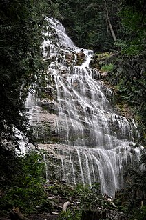
Bridal Veil Falls Provincial Park is a BC Park located on the Trans-Canada Highway just east of Rosedale, British Columbia, Canada, part of the City of Chilliwack. The community of Bridal Falls is located adjacent to the falls and park was well as the interchange between the Trans-Canada and BC Highway 9 and has a variety of highway-based tourism services. Access to the falls requires a short hike from the parking lot and well groomed trails, taking most groups 15-25 minutes.
Williams Lake Indian Reserve, also called the Williams Lake Band Reservation and commonly referred to locally as the Sugarcane Reserve, aka Sugarcane or The Cane or SCB, is an Indian Reserve in British Columbia, Canada, located at the east end of Williams Lake and 12 km east of the city of the same name, on the right bank of the San Jose River. and is home to the Williams Lake Indian Band. The band is part of the Northern Shuswap Tribal Council, also known as the Cariboo Tribal Council, which is one of two tribal councils of the Secwepemc peoples.

Agassiz is a small community located in the Eastern Fraser Valley region of British Columbia, Canada, about 97 kilometres east of Vancouver and 24 kilometres north-east of the city of Chilliwack. The only town within the jurisdiction of the District Municipality of Kent, it contains the majority of Kent's population.

Yarrow is a small community located 90 kilometres east of Vancouver within the City of Chilliwack in British Columbia, Canada. It is in the Fraser Valley at the foot of Vedder Mountain. The village was first settled by Mennonites in the late 1920s, following the draining of Sumas Lake and the reclamation of the former lake bed for agriculture.
The Williams Lake First Nation is a First Nations government of the Secwepemc (Shuswap) Nation, located in the Cariboo region of the Central Interior region of the Canadian province of British Columbia, at the city of Williams Lake. It was created when the government of the then-Colony of British Columbia established an Indian Reserve system in the 1860s. It is a member government of the Northern Shuswap Tribal Council. Its main Indian Reserve is Williams Lake Indian Reserve No. 1, a.k.a. "Sugarcane" or "The Cane" or "SCB".
The Esk'etemc First Nation, also known as the Alkali Lake Indian Band, is a First Nations government of the Secwepemc (Shuswap) people, located at Alkali Lake in the Cariboo region of the Central Interior of the Canadian province of British Columbia. It was created when the government of the then-Colony of British Columbia established an Indian Reserve system in the 1860s. It is one of three Secwepemc bands that is not a member of either the Shuswap Nation Tribal Council or the Northern Shuswap Tribal Council.
The Tl'etinqox-t'in Government Office is a First Nations government located in the Chilcotin District in the western Central Interior region of the Canadian province of British Columbia. Governing a reserve communities near Alexis Creek known as Anaham Reserve First Nations or Anaham, it is a member of the Tsilhqot'in Tribal Council aka known as the Tsilhqot'in National Government. The main reserve is officially known as Anahim's Flat No. 1, and is more commonly as Anaham. Other reserves are Anahim's Meadow No. 2 and 2A, and Anahim Indian Reserves Nos. 3 through 18. Anaham, or Anahim and Alexis were chiefs of the Tsilhqot'in during the Chilcotin War of 1864, although they and their people did not take part in the hostilities.
The Manitoba Agricultural Museum is dedicated to collecting vintage farm machinery and buildings from 1900 and before. Located on 50 acres (200,000 m2) near Austin, Manitoba in the Municipality of North Norfolk, to date they have amassed over 500 pieces of machinery and a pioneer village consisting of more than 20 buildings complete with artifacts. This is Canada’s largest collection of vintage equipment. The facilities include a camping and picnic grounds and a souvenir shop.
Nicomen Island is an island in the Fraser River east of Mission and between Deroche (E) and Dewdney (W). Located on the river's north side, and separated from the foot of the Douglas Ranges by Nicomen Slough, the island is near-totally given over to agriculture and constitutes a rural community in its own right, although "downtown Dewdney" is located near its western end and the Indian Reserve of the Lakahahmen First Nation is located about mid-way along its north side.
Matsqui Island is a large island in the Fraser River in the Central Fraser Valley region of British Columbia, Canada, located between the City of Abbotsford (S) and the District of Mission (N) and about a mile downstream from the Mission Bridge. Though technically located within the District of Mission, Matsqui Island and adjoining sandbars are part of the Matsqui Indian Reserve and are governed by the Matsqui First Nation.
The Tahltan First Nation, also known as the Tahltan Indian Band, is a band government of the Tahltan people. Their main community and reserves are located at Telegraph Creek, British Columbia. Their language is the Tahltan language, which is an Athabaskan language also known as Nahanni, is closely related to Kaska and Dunneza. Their Indian and Northern Affairs Canada band number is 682. The Tahltan First Nation is joined with the Iskut First Nation in a combined tribal council-type organization known as the Tahltan Nation.
The Lyackson First Nation is a First Nations band government located at Chemainus, British Columbia, Canada, on Vancouver Island.
The Leqʼ a꞉ mel First Nation, formerly known as the Lakahahmen First Nation, is a First Nations band government whose community and offices are located in the area near Deroche, British Columbia, Canada, about 12 kilometres east of the District of Mission. They are a member government of the Sto:lo Nation Chiefs Council, which is one of two tribal councils of the Sto:lo.
Sumas was a district municipality in the Fraser Valley region of British Columbia, Canada, located between the then-Village of Abbotsford (W) and Chilliwack (E). It was amalgamated with the Village of Abbotsford in 1972 into the District of Abbotsford.

The Yarrow Ecovillage is an intentional community in Yarrow, British Columbia, Canada. Yarrow is a settlement of 3,000 population within the municipal boundaries of Chilliwack, British Columbia. The Ecovillage is a member-designed community that aims to achieve a more socially, ecologically and economically sustainable way of life. The Ecovillage's master plan for the 10-hectare (25-acre) former dairy farm, foresaw three main legal entities: An 8-hectare (20-acre) organic farm, a 31-unit multigenerational cohousing community, and a mixed-use development with just under 2800 m2 of commercial space, a 17-unit senior cohousing community and a learning centre.
Inkaneep is an unincorporated community located on the east side of the Okanagan River within Osoyoos Indian Reserve No. 1, between the towns of Oliver and Osoyoos, British Columbia, Canada, in that province's South Okanagan region.
Lindell Beach is a rural farming village in the Columbia Valley of the Lower Mainland region of the province of British Columbia, Canada, lying south of the City of Chilliwack. It is located at the south end of Cultus Lake which is the main waterbody in the Columbia Valley in the South Fraser Valley, and just north of the boundary of the United States.
Chilliwack is a city made up of several amalgamated villages and communities. The urban core has a decidedly north–south axis bisected by the Trans-Canada Highway. The city is bounded in north by the Fraser River, in the east by the Eastern Hillsides, in the south by the Canada-U.S. border, and in the west by the Vedder Canal.

Morrow Island is a small island located off the shore of Grizzly Bay in the San Francisco Bay Area of California. It is part of Solano County, California, and partially administered by Reclamation District 2138. Its coordinates are 38°07′00″N122°05′11″W. It has an elevation of 2 meters to 7 feet.
References
- ↑ BC Names entry "Atchelitz (community)"
- ↑ "Atchelitz Threshermen's Association (ATA)". Atchelitz Threshermens Association - ATA. Archived from the original on 2013-07-03. Retrieved 2020-03-21.
- ↑ "Atchelitz Threshermens Association Pioneer Village". Tourism Chilliwack. Retrieved 2020-03-21.
- ↑ "Fun Things To Do in Chilliwack: Little Antique Houses of Atchelitz". PerfectDayToPlay Blog. 2019-08-16. Retrieved 2020-03-21.
Coordinates: 49°07′00″N122°01′00″W / 49.11667°N 122.01667°W