
Valby ( ) is one of the 10 official districts of Copenhagen Municipality, Denmark. It is in the southwestern corner of Copenhagen Municipality, and has a mixture of different types of housing. This includes apartment blocks, terraced housing, areas with single-family houses and allotments, plus the remaining part of the old Valby village, around which the district has formed, intermingled with past and present industrial sites.
Brønshøj-Husum is one of the 10 official districts of Copenhagen Municipality, Denmark. The district is bisected by Frederikssundsvej and consists mainly of vast areas of single family detached homes. It lies on the northwest border of the municipality. It covers an area of 8.73 km2, has a population of 39,588. The district, now a quiet suburban area, has developed around the two old villages of Brønshøj and Husum.
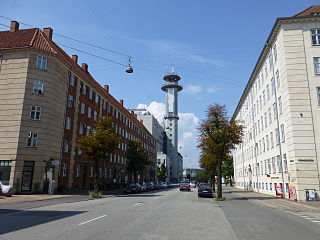
Husum is a predominantly residential neighbourhood in the Brønshøj-Husum district of Copenhagen, Denmark. Located approximately 7 km to the northwest of the city centre, between Vestvolden and Utterslev Mose, it is centred on Frederikssundsvej and Husum Torv. The area to the north of Frederikssundsvej is dominated by Housing estates while the area to the south of the street consists mainly of single-family detached home and terraced houses.
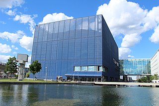
DR Koncerthuset, previously known in English as Copenhagen Concert Hall, is a concert hall designed by Jean Nouvel. It forms part of the new DR Byen complex, which houses the Danish Broadcasting Corporation (DR) and is located in the northern part of Ørestad – an ambitious development area in Copenhagen, Denmark.

Søborg is a neighbourhood in Gladsaxe Municipality, located some 10 km northwest of central Copenhagen, Denmark.
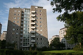
Bellahøj is an area situated 5 kilometres to the northwest of central Copenhagen, Denmark. It features the Bellahøj Houses, a functionalist housing project, as well as parkland with an open-air theatre. The 37 metre high hill situated in Bellahøj Park is the highest point in Copenhagen. The area offers an extensive view over the skyline of Copenhagen.

Tingbjerg is a large housing project designed and built from 1950 to 1972 by Steen Eiler Rasmussen as principal architect. It is located in Copenhagen County, 6 km northwest of the center of Copenhagen in Denmark. This parish is one of the poorest and the most multicultural in Denmark: according to the official statistics in Denmark, in 2022, of 6,278 inhabitants, 68.5 are either immigrants or descendant of immigrants from not western countries.

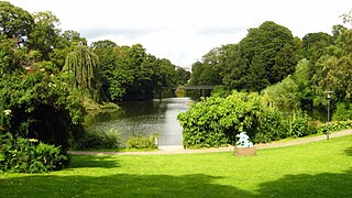
The Lakes in Copenhagen, Denmark is a row of three rectangular lakes curving around the western margin of the City Centre, forming one of the oldest and most distinctive features of the city's topography. The paths around them are popular with strollers, bikers and runners.
Copenhagen is a green city well endowed with open spaces. It has an extensive and well-distributed system of parks that act as venues for a wide array of events and urban life. As a supplement to the regular parks, there are a number of congenial public gardens and some cemeteries doubling as parks. It is official municipal policy in Copenhagen that all citizens by 2015 must be able to reach a park or beach on foot in less than 15 minutes.

Østerbrogade is the principal shopping street and thoroughfare in the Østerbro district of Copenhagen, Denmark. It extends from Lille Triangel at the north-eastern tip of The Lakes, passes Trianglen, and continues to Svanemøllen station from where it becomes Strandvejen.

The Søholm Row Houses, designed by the Danish architect Arne Jacobsen in Klampenborg just north of Copenhagen, were completed in the late 1940s and early 1950s. Together with his Bellavista developments, the Søholm houses helped to establish Jacobsen's international reputation.
Nordvest or The North West Block is an area in Denmark's Copenhagen municipality. It is located in the southwestern part of the Bispebjerg district. Although there are no clear borders nor any official demarcation, it is broadly recognized as the area covered mostly by the Danish postal code 2400 København NV, although some areas lie outside this postal code. As of 2005, 44,177 people resided in the area.

Kunstnerhjemmet on Gothersgade, opposite the Botanical Garden, in Copenhagen, Denmark, was built in the 1870s to provide affordable accommodation and studio facilities for artists. Founded at the initiative of Ferdinand Meldahl, the association behind its construction later also acquired a building on nearby Bartolinsgade. The apartments in the two buildings are open to young, emerging artists as well as aging ones and their widows.
Utterslev is a neighbourhood in the Bispebjerg district of Copenhagen, Denmark. Utterslev is centered on Utterslev Torv and is most known for the Utterslev Mose marshland which straddles the border with Gladsaxe Municipality to the north.

Brønshøjparken is a public park in the Brønshøj district of Copenhagen, Denmark. It is situated on the north side of Frederikssundsvej, just east of the original village and west of the intersection with Borups Allé.

Adelgade is a street in central Copenhagen, Denmark. It runs from Gothersgade in the south to Sankt Pauls Plads with St. Paul's Church in the north. The first half of the street is dominated by modern buildings while its last section passes through the Nyboder district.
Borups Allé is a major artery in the northwestern part of inner Copenhagen, Denmark. The 3.2 km long street runs from Jagtvej at Nuuks Plads in the southeast to Bellahøj in the northwest. Just before Hulgårdsvej, part of Ring 2, Borups Allé is joined by Bispeengbuen, an elevated road section that connects it to Åboulevard-Ågade and H. C. Andersens Boulevard in the city centre. The rest of Borups Allé is the first leg of the National Road 16, part of the Danish national road network. It continues as a six-lane road to Frederikssundsvej where it becomes Hareskovvej and later the Hillerød Motorway at Utterslev Mose.

Emdrup is a neighbourhood straddling the border between the Bispebjerg and Østerbro district of Copenhagen, Denmark. It is located between Utterslev Mose in the west and the Helsingør Motorway in the east, just south of the border with Gladsaxe and Gentofte municipalities. Emdrup is a mainly residential neighbourhood, boasting a combination of apartment buildings and areas with single-family detached home. Emdrup station is located on the Farum radial of the S-train system. AU Campus Emdrup, Aarhus University's Copenhagen campus, is situated just north of the station. The most important greenspaces are Lake Emdrup with its small lakeside park in the east, Utterslev Mose in the west and Emdrupparken with sport facilities in the north.

Nyelandsvej is a street in the Frederiksberg district of Copenhagen, Denmark. It runs from Falkoner Allé in the southeast to a roundabout at the north end of Dalgas Boulevard in the northwest. The more urban, eastern part of the street, between Falkoner Allé and Nordre Fasanvej, separates an area with Copenhagen Business School's Solbjerg Campus and Frederiksberg Centret to the south from the Svømmehal Quarter to the north. The western part of the street is passes the multi-purpose venue Keddelhallen and Frederiksberg Hospital before entering an area with Single-family detached homes.

Fæstningskanalen is a canal in central Kongens Lyngby, Lyngby-Taarbæk Municipality, Copenhagen, Denmark. Created in the 1880s as part of the new fortification ring around the Danish capital, it runs from Lyngby Lake in the west to Lyngby Hovedgade in the east. From there it originally continued to Ermelunden in Jægersborg Dyrehave, but this last leg of the canal is no longer filled with water. The project also included a more upstream straightening of the section of Mølleåen that connects Furesø in the west to the west side of Lyngby Lake in the east. The canal complemented the West Rampart (Vestvolden) and a series of coastal fortresses which were built at the same time. In the event of an enemy invasion, a dam at each end of the canal, one at Frederiksdal and one at Ermelunden, would be opened, and the natural drainage of Lyngby Lake would be blocked, leading to the flooding of an extensive area of land along Hvidørebækken all the way out to the Øresund coast. Water would also be led through Gentofte Lake to Utterslev Mose, leading to further floodings. Together with the moat in front of the West Rampart, this would create a complete water barrier around the Danish capital.


