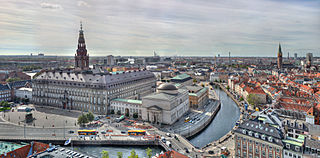
Copenhagen is the capital and most populous city of Denmark, with a population of around 650,000 in the municipality and 1.4 million in the urban area. The city is on the islands of Zealand and Amager, separated from Malmö, Sweden, by the Øresund strait. The Øresund Bridge connects the two cities by rail and road.

Valby ( ) is one of the 10 official districts of Copenhagen Municipality, Denmark. It is in the southwestern corner of Copenhagen Municipality, and has a mixture of different types of housing. This includes apartment blocks, terraced housing, areas with single-family houses and allotments, plus the remaining part of the old Valby village, around which the district has formed, intermingled with past and present industrial sites.

Vanløse is one of the 10 official districts of Copenhagen Municipality, Denmark. It lies on the western border of the municipality. Vanløse covers an area of 6.69 km2, and has a population of 36,115, making Vanløse the smallest district of Copenhagen, by population.
Brønshøj-Husum is one of the 10 official districts of Copenhagen Municipality, Denmark. The district is bisected by Frederikssundsvej and consists mainly of vast areas of single family detached homes. It lies on the northwest border of the municipality. It covers an area of 8.73 km², has a population of 39,588. The district, now a quiet suburban area, has developed around the two old villages of Brønshøj and Husum.
Brønshøj, part of the municipality of Copenhagen, forms, together with Husum, the administrative city district (bydel) of Brønshøj-Husum, in Denmark.
Husum is a predominantly residential neighbourhood in the Brønshøj-Husum district of Copenhagen, Denmark. Located approximately 7 km to the northwest of the city centre, between Vestvolden and Utterslev Mose, it is centred on Frederikssundsvej and Husum Torv. The area to the north of Frederikssundsvej is dominated by Housing estates while the area to the south of the street consists mainly of single-family detached home and terraced houses.

Copenhagen Municipality, also known in English as the Municipality of Copenhagen, located in the Capital Region of Denmark, is the largest of the four municipalities that constitute the City of Copenhagen, the other three being Dragør, Frederiksberg, and Tårnby. The Municipality of Copenhagen constitutes the historical city centre and the majority of its landmarks. It is the most populous in the country with a population of 656,787 inhabitants, and covers 86.4 square kilometres (33.4 sq mi) in area,. Copenhagen Municipality is located at the Zealand and Amager islands and totally surrounds Frederiksberg Municipality on all sides. The strait of Øresund lies to the east. The city of Copenhagen has grown far beyond the municipal boundaries from 1901, when Frederiksberg Municipality was made an enclave within Copenhagen Municipality. Frederiksberg has the largest population density of the municipalities of Denmark.

Tingbjerg is a large housing project designed and built from 1950 to 1972 by Steen Eiler Rasmussen as principal architect. It is located in Copenhagen County, 6 km northwest of the center of Copenhagen in Denmark. This parish is one of the poorest and the most multicultural in Denmark: according to the official statistics in Denmark, in 2022, of 6,278 inhabitants, 68.5 are either immigrants or descendant of immigrants from not western countries.
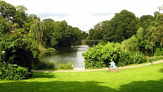
Copenhagen is a green city well endowed with open spaces. It has an extensive and well-distributed system of parks that act as venues for a wide array of events and urban life. As a supplement to the regular parks, there are a number of congenial public gardens and some cemeteries doubling as parks. It is official municipal policy in Copenhagen that all citizens by 2015 must be able to reach a park or beach on foot in less than 15 minutes.
HF-Centret Efterslægten was founded as Efterslægtselskabets Skole by the philanthropic society Selskabet for Efterslægten on 4 March 1786 as a lower middle school and started teaching on 3 January 1787. In 1881 it also became a Latin school and in 1886 the first students with the Danish Studenter-eksamen graduated. In 1919 the institution was taken over by the Copenhagen Municipality, and 1958 the school began admission of girls. In 1991, the school changed name into "HF-Centret Efterslægten", and in 1993 the last students were graduated with Studenter-eksamen, as now the Higher Preparatory Examination (HF) is offered instead, both as a two-year programme and as individual courses for young people and adults. School motto: Non nobis.

Utterslev Mose is a large semi-natural area of lakes, reed beds and parkland located on the border between Copenhagen and Gladsaxe municipalities, approximately six kilometers northwest of central Copenhagen, Denmark. It is surrounded by the neighbourhoods Brønshøj, Tingbjerg, Utterslev, Søborg and Emdrup. It is known for its rich bird life and has a dense network of walking and cycling trails.
Nordvest or The North West Block is an area in Denmark's Copenhagen municipality. It is located in the southwestern part of the Bispebjerg district. Although there are no clear borders nor any official demarcation, it is broadly recognized as the area covered mostly by the Danish postal code 2400 København NV, although some areas lie outside this postal code. As of 2005, 44,177 people resided in the area.
The Copenhagen Police Headquarters building is located on Polititorvet southwest of the centre of Copenhagen, Denmark. Designed by Hack Kampmann and Aage Rafn in 1924 in the Neoclassical style, often referred to as Nordic Classicism, it was completed in 1924.
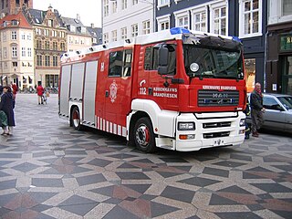
The Greater Copenhagen Fire Department forms the largest municipal fire brigade in Denmark with more than 1000 employees. This includes firefighters, ambulance personnel, administration and service workers and workers in fire prevention.
Brønshøjparken is a public park in the Brønshøj district of Copenhagen, Denmark. It is situated on the north side of Frederikssundsvej, just east of the original village and west of the intersection with Borups Allé.

Brønshøj Rytterskole is a listed building on Brønshøj Torv in the Brønshøj-Husum district of Copenhagen, Denmark. It is owned by Copenhagen Municipality and used as a venue for local cultural events and meetings.

Bispebjerg Cemetery, established in 1903 on the moderately graded north slope of Bispebjerg Hill, is the newest of five municipal cemeteries in Copenhagen, Denmark. The main entrance to the cemetery is located next to the monumental Grundtvig's Church, built later in 1921–40. A tall poplar avenue extends from the main entrance towards Utterslev Mose in the west. The old chapel has been converted into a centre for dance and is now known as Dansekapellet. One of the cemetery’s main attractions is an avenue of Japanese cherry trees that, when in bloom during spring, form a long, pink tunnel.

Vestvolden is a rampart complex west of Copenhagen, Denmark. Stretching approximately 14 kilometres (9 mi) from Avedøre in the south to Utterslev Mose in the north, it is part of the last generation of land fortifications of the city. Built in the period 1888–1892 by up to 2,000 workers, it was the largest construction project of its time in Denmark. Vestvolden was divided into two fortifications end to end, the southern one named Vestenceinten and the northern, much shorter one named Husumenceinten; the name Vestvolden emerged as an informal collective term for the two. The building of this fortification system began during the so-called "Provisorietiden" 1885–1894. Under the Prime Minister who lacked a parliamentary majority but still refused to resign, J.B.S. Estrup. Instead this Prime Minister managed to enforce his annual Financial Laws, by bringing about King Christian IX's support for Provisional Financial Laws. This included support from the so-called Landstinget as well. The Landstinget was a smaller assembly of politicians, of which half of its members were chosen by the Monarch.

Emdrup is a neighbourhood straddling the border between the Bispebjerg and Østerbro district of Copenhagen, Denmark. It is located between Utterslev Mose in the west and the Helsingør Motorway in the east, just south of the border with Gladsaxe and Gentofte municipalities. Emdrup is a mainly residential neighbourhood, boasting a combination of apartment buildings and areas with single-family detached home. Emdrup station is located on the Farum radial of the S-train system. AU Campus Emdrup, Aarhus University's Copenhagen campus, is situated just north of the station. The most important greenspaces are Lake Emdrup with its small lakeside park in the east, Utterslev Mose in the west and Emdrupparken with sport facilities in the north.

Jagtvej is a major artery in the Nørrebro and Østerbro districts of Copenhagen, Denmark. It runs from Ågade on the border with Frederiksberg in the southwest to Østerbrogade in the northeast, linking Falkoner Allé with Strandboulevarden. The street passes Assistens Cemetery, University of Copenhagen's North Campus and Fælled Park.

