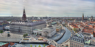
Copenhagen is the capital and most populous city of Denmark, with a population of 1.4 million in the urban area. The city is situated on the islands of Zealand and Amager, separated from Malmö, Sweden, by the Øresund strait. The Øresund Bridge connects the two cities by rail and road.
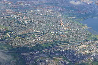
Hvidovre Municipality is a municipality in the Capital Region near Copenhagen on the island of Zealand (Sjælland) in eastern Denmark. The municipality covers an area of 22 km2, and has a total population of 53,760. Its mayor is Anders Wolf Andresen, a member of the Green Left political party.

The Copenhagen Metro is a light rapid transit system in Copenhagen, Denmark, serving the municipalities of Copenhagen, Frederiksberg, and Tårnby.

The urban area of Copenhagen, lying mostly in the Capital Region of Denmark but also in Region Zealand, consist of Copenhagen and Frederiksberg municipalities and the former Copenhagen County. In all, it consists of 18 municipalities, and except parts of Ballerup, Greve, Ishøj, former Søllerød and former Værløse, mentioned with their population included from 2007. Ishøj and Greve Strand are included for the first time since 1999. As of 1 January 2024, this area had a population of 1,378,649. Statistics Denmark states that the definition of the urban area is based on UN's 200m definition.

The Copenhagen S-train, the S-train of Copenhagen, Denmark, is a key part of public transport in the city. It is a hybrid urban-suburban rail serving most of the Copenhagen urban area, and is analogous to the S-Bahn systems of Berlin, Vienna and Hamburg. The trains connect the Copenhagen inner city with Hillerød, Klampenborg, Frederikssund, Farum, Høje-Taastrup and Køge. There are 170 km (110 mi) of double track with 87 S-train stations, of which eight are in neighbouring towns outside greater Copenhagen.
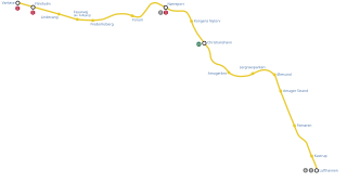
M2 is a line of the Copenhagen Metro, colored yellow on the map. It runs from Vanløse to Lufthavnen through the center of Copenhagen, sharing track with the M1 from Vanløse to Christianshavn. The line was built along with M1 as part of the redevelopment of Ørestad. The principle of the line was passed in 1992, and construction commenced in 1998. The line opened in several stages between 2002 and 2007. It is owned by Metroselskabet and operated by Metro Service, and operates with a headway between four and twenty minutes.

Vesterbro is one of the 15 administrative, statistical, and city tax districts (bydele) comprising the municipality of Copenhagen, Denmark. It covers an area of 3.76 km2 (1.45 sq mi), and has a population of 51,466 and a population density of 13,688 per km2.

Kongens Enghave, commonly known as Sydhavnen or the postal district of 2450 Copenhagen SV (southwest) is a district in southern Copenhagen. While its core is a largely pre-WWII former working class district, it also contains an upscale residential area along the harbour having been developed after 2000, scattered industrial areas, large parks such as Valbyparken and Sydhavnstippen, allotment gardens and parts of Vestre Kirkegård, the city's largest cemetery.

Valby ( ) is one of the 10 official districts of Copenhagen Municipality, Denmark. It is in the southwestern corner of Copenhagen Municipality, and has a mixture of different types of housing. This includes apartment blocks, terraced housing, areas with single-family houses and allotments, plus the remaining part of the old Valby village, around which the district has formed, intermingled with past and present industrial sites.
Boldklubben Fremad Amager is a Danish professional football club based in the district of Amager Vest, Copenhagen. As of the 2024–25 season, the club's senior men's team play in 2nd Division, the third tier in the Danish football league system. The club have primarily played their home games at Sundby Idrætspark since the stadium's inauguration in 1922.

DBU Copenhagen is the local governing body for association football and futsal in Copenhagen, Denmark. They are responsible for the governance and development of men's and women's football at all levels in the region. DBU Copenhagen is a member of the union of local football associations, DBU Bredde, under the Danish Football Association (DBU) and the National Olympic Committee and Sports Confederation of Denmark (DIF). The headquarters is located at the Svanemølleanlægget at Østerbro after previously having their residence at the national football stadium. Clubs situated in the municipalities of Copenhagen, Frederiksberg, Gentofte, Tårnby and Dragør can be accepted as members of DBU Copenhagen. Due to historical reasons a number of older clubs from other municipalities are also member of the association. As per 2020, the association consisted of 157 clubs and 45,627 members with the Østerbro-based club BK Skjold being the largest club membership-wise within the association and on a national level.

Copenhagen Municipality, also known in English as the Municipality of Copenhagen, located in the Capital Region of Denmark, is the largest of the four municipalities that constitute the City of Copenhagen, the other three being Dragør, Frederiksberg, and Tårnby. The Municipality of Copenhagen constitutes the historical city centre and the majority of its landmarks. It is the most populous in the country with a population of 659,350 inhabitants, and covers 86.4 square kilometres (33.4 sq mi) in area,. Copenhagen Municipality is located at the Zealand and Amager islands and totally surrounds Frederiksberg Municipality on all sides. The strait of Øresund lies to the east. The city of Copenhagen has grown far beyond the municipal boundaries from 1901, when Frederiksberg Municipality was made an enclave within Copenhagen Municipality. Frederiksberg has the largest population density of the municipalities of Denmark.

Frederiksberg is a part of the Capital Region of Denmark. It is an independent municipality, Frederiksberg Municipality, separate from Copenhagen Municipality, but both are a part of the region of Copenhagen. It occupies an area of less than 9 km2 and had a population of 103,192 in 2015.
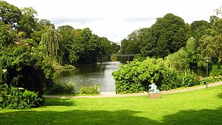
Copenhagen is a green city well endowed with open spaces. It has an extensive and well-distributed system of parks that act as venues for a wide array of events and urban life. As a supplement to the regular parks, there are a number of congenial public gardens and some cemeteries doubling as parks. It is official municipal policy in Copenhagen that all citizens by 2015 must be able to reach a park or beach on foot in less than 15 minutes.
Districts of Copenhagen are often based on informal designations based on historic origins, often with alternative names and loosely defined boundaries. Copenhagen Municipality is divided into 10 official administrative districts but they often comprise areas of a heterogeneous character which are informally not seen as one district. Some districts have earlier been official subdivisions and thus have semi-official boundaries. Copenhagen postal code designations often correspond to district boundaries but in some cases differ from them, as an example parts of the city centre has the postal code København V which is generally associated with Vesterbro.

Vesterbrogade is the main shopping street of the Vesterbro district of Copenhagen, Denmark. The 1.5 km long street runs from the City Hall Square in the east to Pile Allé in Frederiksberg in the west where it turns into Roskildevej. On its way, it passes Copenhagen Central Station as well as the small triangular square Vesterbros Torv. It is one of four such -bro streets, the other being Nørrebrogade, Østerbrogade and Amagerbrogade.
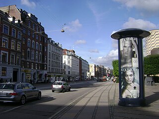
Gammel Kongevej is the principal shopping street of Frederiksberg in Copenhagen, Denmark. Running roughly parallel to Frederiksberg Allé and Vesterbrogade, it extends from Vesterport station at the southern end of The Lakes and continues for some 1.8 km west to Frederiksberg City Hall Square where it continues as Smallegade. In the opposite end, Jernbanegade connects it to Copenhagen City Hall Square.
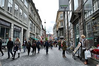
Købmagergade is a pedestrian shopping street in the Old Town of Copenhagen, Denmark. It connects Amagertorv on Strøget to Nørreport station, although the last section, north of Kultorvet, is part of Frederiksborggade, which continues on the other side of the railway station.


