This is a list of squares in Copenhagen, Denmark.
This is a list of squares in Copenhagen, Denmark.
In Danish, a square is typically called a Plads (Højbro Plads, Israels Plads etc.) or a Torv (or -torv, Christianshavns Torv, Nytorv). The Danish use the word "plads" where an English-speaker would generally use the word "square." This follows the pattern established in other European languages: the German use the cognate "platz" (Berlin's Potsdamer Platz); the French "place" (Paris' Place de Vosque); the Spanish "plaza" (like Madrid's Plaza Mayor); and the Italian "piazza" (Rome's Piazza Navona). The word "torv" literally means "market" and in toponyms often commemorates a market that used to take place at the site: Amagertorv was the place where the Amager farmers used to sell their produce and Kultorvet (literally "The Coal Market") was Copenhagen's main coal market. However, this is not always the case: Søtorvet was never a market place, nor was Sølvtorvet ever a hub for trade in silver. The word "byrum" (literally "urban room") has a somewhat broader meaning then "plads" or "torv", roughly similar to "urban space" (or "public space"), but is purely a generic term which is not used in toponyms.
| Name | Image | Neighbourhood | Coordinates | Created | Streets | Landmarks |
|---|---|---|---|---|---|---|
| Karen Blixens Plads |  | Ørestad | Ørestad | |||
| Kay Fiskers Plads | | Ørestad | Ørestad | |||
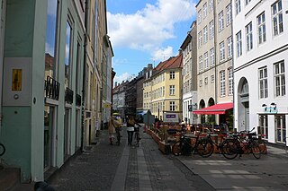
| Mikado Plads |  | Ørestad | IT University of Copenhagen | |||
| Svend Aukens Plads |  | Islands Brygge | Ørestads Boulevard, Njalsgade | |||
| Sundbyvester Plads |  | Sundby | Amagerbrogade, Sundbyvestervej |
| Name | Image | Neighbourhood | Coordinates | Created | Streets | Landmarks |
|---|---|---|---|---|---|---|
| Brønshøj Torv |  | Brønshøj | Frederikssundsvej | Brønshøj Rytterskole | ||
| Husum Torv |  | Husum | Frederikssundsvej, Islevhusvej |
| Name | Image | Neighbourhood | Coordinates | Created | Streets | Landmarks |
|---|---|---|---|---|---|---|
| Bispebjerg Torv |  | Bispebjerg | Frederiksborgvej, Tagensvej | Bispebjerg Cemetery | ||
| Emdrup Torv |  | Emdrup | Frederiksborgvej, Emdrupvej | |||
| Lyngsies Plads |  | Bispebjerg | Lygten | Lygten Station |
| Name | Image | Neighbourhood | Coordinates | Created | Streets | Landmarks |
|---|---|---|---|---|---|---|
| Balders Plads |  | Nørrebro | ||||
| Blågårds Plads |  | Nørrebro | 1902 | Blågårdsgade | Blågård Church | |
| Borups Plads |  | Nørrebro | Borups Allé, Lundtoftegade, Stefansgade | |||
| Den Røde Pads | Nørrebro | |||||
| Det Sorte Marked |  | Nørrebro | ||||
| Nuuk Plads |  | Nørrebro | ||||
| Sankt Hans Torv |  | Nørrebro | Blegdamsvej, Fælledvej, Nørre Allé | St. John's Church |
| Name | Image | Neighbourhood | Coordinates | Created | Streets | Landmarks |
|---|---|---|---|---|---|---|
| Amerika Plads |  | Southern Freeport | 2008 | |||
| Bopa Plads |  | Inner Østerbro | Randersgade, Viborggade | |||
| Dahlerups Plads |  | Søndre Frihavn | Dahlerup Warehouse | |||
| Gunnar Nu Hansens Plads |  | Inner Østerbro | Østerbrogade | Østerbro Stadium, Øbro Hallen, Sparta Hallen | ||
| Melchiors Plads |  | Inner Østerbro | Nordre Frihavnsgade | |||
| Oslo Plads |  | Inner Østerbro | Dag Hammarskjölds Allé, Store Kongensgade, Grønningen | Østerport Station, Østre Anlæg | ||
| Østerfælled Torv |  | Inner Østerbro | Theatre Republique | |||
| Sankt Jakobs Plads |  | Outer Østerbro | Østerbrogade | |||
| Sankt Kjelds Plads |  | Østerbro | Østerbrogade | |||
| Trianglen |  | Inner Østerbro | Blegdamsvej, Nordre Frihavnsgade, Østerbrogade | Bien | ||
| Trondhjems Plads |  | Nørrebro | ||||
| Victor Borges Plads |  | Østerbro | Nordre Frihavnsgade | |||
| Århus Plads |  | Østerbro | Århusgade |
| Name | Image | Neighbourhood | Coordinates | Created | Streets | Landmarks |
|---|---|---|---|---|---|---|
| Toftegårds Plads |  | Valby | Gammel Køge Landevej, Vigerslev Allé | Spinderiet | ||
| Valby Tingsted |  | Valby | Valby Langgade | Spinderiet | ||
| Ålholm Plads | Valby | Roskildevej, Ålholvej |
| Name | Image | Neighbourhood | Coordinates | Created | Streets | Landmarks |
|---|---|---|---|---|---|---|
| Banegårdspladsen |  | Vesterbro | Vesterbrogade | Copenhagen Central Station | ||
| Bryggernes plads |  | Carlsberg | ||||
| Enghave Plads |  | Vesterbro | 1880s | Enghavevej, Istedgade | Church of Christ | |
| Halmtorvet |  | Vesterbro | 1879 | Sønder Boulevard | Kødbyen, Øksnehallen | |
| Industrikulturens Plads |  | Carlsberg | ||||
| Litauens Plads |  | Vesterbro | 1879 | Saxogade, Dannebrogsgade | Gethseman's Church | |
| Liva Weels Plads |  | Vesterbro | Ny Carlsbergvej | |||
| Mozarts Plads |  | South Harbour | 1932 | Borgmester Christiansens Gade | ||
| Onkel Dannys Plads |  | Kødbyen | 1879 | Halmtorvet | Kødbyen | |
| Otto Krabbes Plads |  | Vesterbro | Westend | |||
| Tove Ditlevsens Plads |  | Vesterbro | 1880s | Enghavevej, Mathæusgade | Tove Ditlevsens Skole | |
| Vesterbros Torv |  | Vesterbro | Gasværksvej, Vesterbrogade | Elijah's Church | ||
| Name | Image | Neighbourhood | Coordinates | Created | Streets | Landmarks |
|---|---|---|---|---|---|---|
| Dan Turèlls Plads | Vangede |
| Name | Image | Neighbourhood | Coordinates | Created | Streets | Landmarks |
|---|---|---|---|---|---|---|
| Jernbanepladsen |  | Kongens Lyngby | Lyngby Station | |||
| Lyngby Torv |  | Kongens Lyngby | Lyngby Town Hall | |||
| Sorgenfri Torv | Sorgenfri | |||||
| Ulrikkenborg Plads |  | Ulrikkenborg | Lyngby Station | |||
| Virum Torv |  | Virum |

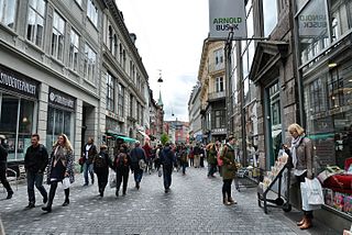
Strøget is a pedestrian, car-free shopping area in Copenhagen, Denmark. This popular tourist attraction in the centre of town is one of the longest pedestrian shopping streets in Europe at 1.1 km. Located at the centre of the old city of Copenhagen, it has long been one of the most high-profile streets in the city.

Valby ( ) is one of the 10 official districts of Copenhagen Municipality, Denmark. It is in the southwestern corner of Copenhagen Municipality, and has a mixture of different types of housing. This includes apartment blocks, terraced housing, areas with single-family houses and allotments, plus the remaining part of the old Valby village, around which the district has formed, intermingled with past and present industrial sites.

Gammeltorv is the oldest square in Copenhagen, Denmark. With adjoining Nytorv it forms a common space along the Strøget pedestrian zone. While the square dates back to the foundation of the city in the 12th century, most of its buildings were constructed after the Great Fire of 1795 in Neoclassical style. Another dominating feature is the Caritas Well, a Renaissance fountain erected by King Christian IV in 1610.

Gråbrødretorv is a public square in the centre of Copenhagen, Denmark, just off the pedestrian street Strøget.

Gammel Strand is a street and public square in central Copenhagen, Denmark. On the south side it borders on the narrow Slotsholmens Canal while the north side is lined by a row of brightly coloured houses from the 18th and 19th century. Across the canal, Thorvaldsens Museum and Christiansborg Palace are seen on the island Slotsholmen.

Amagertorv is a public square in the district of Indre By in central Copenhagen, Denmark. Today it forms part of the Strøget pedestrian zone, and is often described as the most central square in Copenhagen. Second only to Gammeltorv, it is also one of the oldest, taking its name from the Amager farmers who in the Middle Ages came into town to sell their produce at the site.

Sankt Annæ Plads is a public square which marks the border between the Nyhavn area and Frederiksstaden neighborhoods of central Copenhagen, Denmark. It is a long narrow rectangle which extends inland from the waterfront, at a point just north of the Royal Danish Playhouse at the base of the Kvæsthus Pier, now known as Ofelia Plads, until it meets Bredgade. A major renovation of the square was completed in 2016.The Garrison Church is located on the south side of the square. Amaliegade, one of the two axes on which Frederiksstaden is centered, extends from the square.

Højbro Plads is a rectangular public square located between the adjoining Amagertorv and Slotsholmen Canal in the City Centre of Copenhagen, Denmark. It takes its name from the Højbro Bridge which connects it to the Slotsholmen island on the other side of the canal while Gammel Strand extends along the near side of the canal.

Sankt Hans Torv is a public square in the heart of the Nørrebro district of Copenhagen, Denmark. It is dominated by a large granite sculpture by Jørgen Haugen Sørensen and is known for its thriving café scene. St. John's Church, the largest and oldest church in Nørrebro, is situated just east of the square.
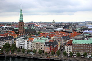
Ved Stranden is a canal side public space and street which runs along a short section of the Zealand side of Slotsholmen Canal in central Copenhagen, Denmark. It begins at Holmens Kanal, opposite the Church of Holmen, and runs west along the canal for one and a half blocks before widening into a small, triangular space adjacent to Højbro Bridge and Højbro Plads. The name of the street refers to Gammel Strand, 'Old Beach', which it formed part of until 1961.
Christianshavns Torv is the central public square of the Christianshavn neighborhood in Copenhagen, Denmark. It is situated at the intersection of Torvegade and Christianshavn Canal, roughly at the center of the area.

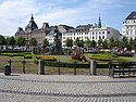
Israels Plads is a large public square in central Copenhagen, Denmark, located in the area between Nørreport station and The Lakes. Its northern part hosts a market. Its southern part was extensively redesigned in 2014, with transition into the adjacent Ørsted Park.

Sankt Annæ Gade is a street in the Christianshavn district of Copenhagen, Denmark. It connects the main harbourfront at Asiatisk Plads in the west to Christianshavn Rampart in the east via the Snorrebroen bridge. Church of Our Saviour is located in the street.

Torvegade is the central thoroughfare of Christianshavn in Copenhagen, Denmark, linking the city centre by way of Knippel Bridge with Amagerside Copenhagen at Christmas Møllers Plads. The street crosses Christianshavn Canal at Christianshavns Torv, the central square of the neighbourhood. The last section of the street runs on the embankment that across Stadsgraven.
Købmagergade is a pedestrian shopping street in the Old Town of Copenhagen, Denmark. It connects Amagertorv on Strøget to Nørreport station, although the last section, north of Kultorvet, is part of Frederiksborggade, which continues on the other side of the railway station.

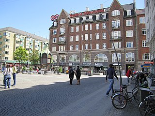
Kultorvet is a public square in the Old Town of Copenhagen, Denmark. Together with Købmagergade and the southern part of Frederiksborggade, it forms a pedestrian zone between Nørreport station and Amagertorv on Strøget. The square is lined with cafés and shops and is a popular venue for outdoor concerts in the summer time. Copenhagen Central Library was from the 1950s based on the square but has now relocated to a building in Krystalgade. Its old building has now been taken over by Niels Brock Copenhagen Business College.

Hauser Plads is a public square in the Old Town of Copenhagen, Denmark. It is separated from the larger, more well-known square Kultorvet by the former Copenhagen Central Library Building. A landscaped playground and Copenhagen Municipality's underground Cleaning Facilities Centre occupies most of the site since a renovation in 2011..
Strædet is the colloquial name of a popular shopping and café street in the Old Town of Copenhagen, Denmark, linking Højbro Plads on Strøget at its eastern end with Regnbuepladsen next to City Hall to the west. The official street names are Læderstræde, Kompagnistræde and Farvergade. The shops along the street are generally smaller and more eclectic than the flagship stores on neighbouring Strøget. It is dominated by art galleries and antique shops. It is known for its rich gay culture with LGBT citizens, shops, bars, restaurants and coffeehouses.

Nikolaj Plads is a public square located at the foot of the former St Nicolas' Church, just off Strøget, in the Old Town of Copenhagen, Denmark. Most of the buildings that line the square date from the rebuilding of the surrounding neighbourhood in the years after the Copenhagen Fire of 1795. The square is a quiet alternative to the much busier squares Amagertorv and Højbro Plads. The former church houses an exhibition space and a restaurant with outdoor service and a small playground is also located at the site.

Gunnar Nu Hansens Plads is a public space in the Østerbro district of Copenhagen, Denmark. It consists of a triangular plaza, located on the west side of Østerbrogade, just north of Parken Stadium, which turns into a wide street and continues for about 200 m to Fælledparken, The street then continues southwest as Per Henrik Lings Allé to Øster Allé. Several sports venues, some of which are listed, are located on the south side of the square. The former Østerfælled Barracks, now a mixed-use development known as Østerfælled Torv, are located on its north side.