
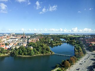
Christianshavns Torv is the central public square of the Christianshavn neighborhood in Copenhagen, Denmark. It is situated at the intersection of Torvegade and Christianshavn Canal, roughly at the center of the area.
Christianshavns Torv is the central public square of the Christianshavn neighborhood in Copenhagen, Denmark. It is situated at the intersection of Torvegade and Christianshavn Canal, roughly at the center of the area.


Christianshavns Torv traces its history back to Johan Semp's 1617 plan for the layout of Christianshavn to be a fortified market town. It was originally known as Børnehustorv [1] after Børnehuset, a royal orphanage which was established in 1622 on its east side. A blue-painted water post was installed in the square in 1633. It was fed by a lead pipe which brought water all the way from Peblinge Lake on the other side of the harbour. [2]
The institution was gradually converted into a prison. The old building was replaced by a new one designed in the Baroque style by Philip de Lange and constructed between 1739 and 1742.


A police station opened in the square in 1815. One of six new local police stations, it covered the Christianshavn and Amagerbro area. It was based in Jacob Bastians Købmandsgård (Jacob Bastian's Commerce House), at No. 1, on the corner of the square and the canal.
Lange's building was demolished in the early 1860s to make way for a new prison building completed in 1864 to designs by Niels Sigfred Nebelong. From 1870 it was known as Christianshavns Straffeanstalt (Christianshavn Penitentiary) and served as a prison for women.
In 1868, the vegetable market at Amagertorv, where the Amager Women had sold their produce for centuries, was moved to Christianshavns Torv. [3] It only existed for around two decades and was in 1889 replaced by a new vegetable market which opened at Vendersgade, later part of Israels Plads. [4]
The coming of the new century brought change to the square. The buildings surrounding it were pulled down in the 1890s and early 1900s and replaced with new ones. [5]
Christianshavn Penitentiary was demolished in 1928 in connection with a widening of Torvegade.

The Greenland Monument was created by Svend Rathsack in bluish granite from Bornholm and installed in the square in 1938. It consists of a Greenlandic hunter with his kayak, placed high on a plinth above two groups of working women. [6]
One of Copenhagen's old telephone kiosks of the original model which was designed by Fritz Koch and first installed in 1896. It is hexagonal with a copper roof over richly decorated wooden friezes.
The square is dominated by the Modernist building Lagkagehuset ("The Layer Cake House"), which was built on the site of the former penitentiary between 1929 and 1932 to a design by Edvard Thomsen. Its name derives from the yellow and white striped facade. Torvegården (Bo. 2–4), at the opposite corner, also facing the canal, is also in the Modernist style and was built between 1940 and 1941 to designs by Svend G. Høyrup. [7]
No. 6 is from 1903 and was designed by an unknown architect. [8] The building at the east side of the square, on the corner of Torvegade (No. 50) and Dronningensgade (No. 48), is from 1900 and was also designed by an unknown architect. [9]
Christianshavn metro station is located on the square. It serves both the M1 and M2 lines of the Copenhagen Metro.

Gammeltorv is the oldest square in Copenhagen, Denmark. With adjoining Nytorv it forms a common space along the Strøget pedestrian zone. While the square dates back to the foundation of the city in the 12th century, most of its buildings were constructed after the Great Fire of 1795 in Neoclassical style. Another dominating feature is the Caritas Well, a Renaissance fountain erected by King Christian IV in 1610.
Christianshavns Vold is a former rampart which was part of the bastioned fortification ring which used to surround Copenhagen, Denmark. Running along the full south-eastern perimeter of Christianshavn and Holmen, it used to form a protective barrier towards the island of Amager. It consists of earthworks with 12 bastions and in front of it ran a moat, Stadsgraven, now forming a broad canal which separates Christianshavn from the rest of Amager. On the other side of Stadsgraven. on Amager, was a lower system of outworks called Christianshavns Enveloppe of which only the northern half survives. Along with Kastellet on the other side of the harbour, it is the only intact part of the fortification system.

Amagertorv, today part of the Strøget pedestrian zone, is often described as the most central square in central Copenhagen, Denmark. Second only to Gammeltorv, it is also one of the oldest, taking its name from the Amager farmers who in the Middle Ages came into town to sell their produce at the site.

Nørre Voldgade is a street in central Copenhagen, Denmark. It runs north-east from Jarmers Plads for approximately 600 metres to Gothersgade where it turns into Øster Voldgade. The succession of Nørre Voldgade, Øster Voldgade and Vester Voldgade together forms a traffic artery which arches around the Zealand side of the central and oldest part of Copenhagen. Nørreport Station, Denmark's busiest railway station, is located in the street.

Brøste House, also known as Potter House after its founder, Thomas Potter, a Scottish born industrialist, is a late 18th-century historic property at Overgaden Oven Vandet 10, overlooking Christianshavn Canal, in the Christianshavn neighbourhood of Copenhagen, Denmark.

Israels Plads is a large public square in central Copenhagen, Denmark, located in the area between Nørreport station and The Lakes. Its north end is home to a covered food market while the south end is currently subject to a comprehensive redesign which will integrate it with the adjoining Ørsted Park.

Asiatisk Plads is a waterfront area in the Christianshavn neighbourhood of Copenhagen, Denmark. It is bounded by Torvegade to the south, next to Knippel Bridge, Strandgade to the east and the Old Dock area to the north. It takes its name from Danish Asia Company which was based at the site from its foundation in 1732 until 1843 when it was dissolved. The Ministry of Foreign Affairs is now based in the area, in a purpose-built office complex from 1980 as well as in the surviving buildings of the Danish Asia Company, its former head office and two converted warehouses, all of which are listed. Asiatisk Plads is frequently used as a metonym for the Ministry.

Sankt Annæ Gade is a street in the Christianshavn district of Copenhagen, Denmark. It connects the main harbourfront at Asiatisk Plads in the west to Christianshavn Rampart in the east via the Snorrebroen bridge. Church of Our Saviour is located in the street.

The Women's Prison at Christianshavn in Copenhagen, Denmark, was a correctional facility which existed under various names from the mid 17th century until 1921. From 1870 it served as a women's prison. Earlier names included Børnehuset and Tugt- og Rasphuset. Its last building, which dated from 1861, was torn down in 1928 to make way for an expansion of Torvegade.

Torvegade is the central thoroughfare of Christianshavn in Copenhagen, Denmark, linking the city centre by way of Knippel Bridge with Amagerside Copenhagen at Christmas Møllers Plads. The street crosses Christianshavn Canal at Christianshavns Torv, the central square of the neighbourhood. The last section of the street runs on the embankment that across Stadsgraven.

Dronningensgade is a street in the Christianshavn district of Copenhagen, Denmark, running parallel to Christianshavn Canal one block to the east, from Christianshavn Rampart in the south to Bådsmandsstræde in the north.

Kultorvet is a public square in the Old Town of Copenhagen, Denmark. Together with Købmagergade and the southern part of Frederiksborggade, it forms a pedestrian zone between Nørreport station and Amagertorv on Strøget. The square is lined with cafés and shops and is a popular venue for outdoor concerts in the summer time. Copenhagen Central Library was from the 1950s based on the square but has now relocated to a building in Krystalgade. Its old building has now been taken over by Niels Brock Copenhagen Business College.

The Dragon Fountain is a fountain located in the City Hall Square in Copenhagen, Denmark. It was designed by Joakim Skovgaard in collaboration with Thorvald Bindesbøll and features a bull in combat with a dragon.

Klostergården, also known as Det Petersenske Jomfrukloster, is a listed Neoclassical property on Amagertorv in the Old Town of Copenhagen, Denmark. The rear side of the building faces Læderstræde. A passageway, Klostergangen, passes through the building.

Wildersgade is a street in the Christianshavn district of Copenhagen, Denmark. It runs along the length of the neighbourhood, parallel to Christianshavn Canal, one block to the east, from the Christiansbro development in the south(west) to Wilder's Canal in the north(east). The street is bisected by Torvegade, Christianshavn's principal thoroughfare, but is otherwise a quiet mainly residential street with cobbling and many old townhouses and storages from the 18th and 19th century.

Bombebøssen is a listed property from 1896 overlooking Christianshavn Canal in the Christianshavn neighbourhood of central Copenhagen, Denmark. It was built by the charity Sømandsstiftelsen Bombebøssen to provide housing for indigent seamen.

Nikolaj Plads is a public square located at the foot of the former St Nicolas' Church, just off Strøget, in the Old Town of Copenhagen, Denmark. Most of the buildings that line the square date from the rebuilding of the surrounding neighbourhood in the years after the Copenhagen Fire of 1795. The square is a quiet alternative to the much busier squares Amagertorv and Højbro Plads. The former church houses an exhibition space and a restaurant with outdoor service and a small playground is also located at the site.

Frederiksborggade is a street in central Copenhagen, Denmark. It runs from Kultorvet square in the southeast to Søtorvet where Queen Louise's Bridge connects it to Nørrebrogade in Nørrebro on the other side of The Lakes. The street is effectively divided in two by Nørreport station on Nørre Voldgade. The short, southern portion, together with Kultorvet and Købmagergade, forms a pedestrian zone between the station and Strøget at Amagertorv. The wider and younger northern portion is open to car traffic.
Sofiegade is a street in the Christianshavn neighbourhood of central Copenhagen, Denmark. It runs from Christianshavns Kanal in the northwest to Christianshavns Voldgade and Christianshavns Vold in the southeast, passing Dronningensgade and Prinsessegade on the way.
| Wikimedia Commons has media related to Christianshavns Torv . |