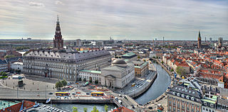
Copenhagen is the capital and most populous city of Denmark, with a population of 1.4 million in the urban area. The city is situated on the islands of Zealand and Amager, separated from Malmö, Sweden, by the Øresund strait. The Øresund Bridge connects the two cities by rail and road.
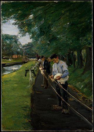
A ropewalk is a long straight narrow lane, or a covered pathway, where long strands of material are laid before being twisted into rope. Due to the length of some ropewalks, workers may use bicycles to get from one end to the other.

Holmen is a water-bound neighbourhood in Copenhagen, Denmark, occupying the former grounds of the Royal Naval Base and Dockyards. In spite of its name, deceptively in singular, Holmen is a congregation of small islands, forming a north-eastern extension of Christianshavn between Zealand and the northern tip of Amager.
Gammelholm is a predominantly residential neighbourhood in the city centre of Copenhagen, Denmark. It is bounded by the Nyhavn canal, Kongens Nytorv, Holmens Kanal, Niels Juels Gade and the waterfront along Havnegade. For centuries, the area was the site of the Royal Naval Shipyard, known as Bremerholm, but after the naval activities relocated to Nyholm, it came under residential redevelopment in the 1860s and 1870s. The new neighbourhood was planned by Ferdinand Meldahl and has also been referred to as "Meldahl's Nine Streets". Apart from the buildings which face Kongens Nytorv, which include the Royal Danish Theatre and Charlottenborg Palace, the area is characterized by homogeneous Historicist architecture consisting of perimeter blocks with richly decorated house fronts.
Christianshavns Vold is a former rampart which was part of the bastioned fortification ring which used to surround Copenhagen, Denmark. Running along the full south-eastern perimeter of Christianshavn and Holmen, it used to form a protective barrier towards the island of Amager. It consists of earthworks with 12 bastions and in front of it ran a moat, Stadsgraven, now forming a broad canal which separates Christianshavn from the rest of Amager. On the other side of Stadsgraven. on Amager, was a lower system of outworks called Christianshavns Enveloppe of which only the northern half survives. Along with Kastellet on the other side of the harbour, it is the only intact part of the fortification system.

Sankt Annæ Plads is a public square which marks the border between the Nyhavn area and Frederiksstaden neighborhoods of central Copenhagen, Denmark. It is a long narrow rectangle which extends inland from the waterfront, at a point just north of the Royal Danish Playhouse at the base of the Kvæsthus Pier, now known as Ofelia Plads, until it meets Bredgade. A major renovation of the square was completed in 2016.The Garrison Church is located on the south side of the square. Amaliegade, one of the two axes on which Frederiksstaden is centered, extends from the square.

Wilders Plads is a waterfront area located just north of Wilders Kanal, a branch of Christianshavns Kanal, in the north-western corner of the Christianshavn neighbourhood of Copenhagen, Denmark. The area is bounded by Christianshavn Canal to the east and Krøyers Plads to the north.

Larsens Plads is a waterfront in Copenhagen, Denmark, which runs along the Zealand side of the Inner Harbour from the Nyhavn canal in the south to the Nordre Toldbod area just south of Langelinie to the north. The name refers to a shipyard which used to occupy the grounds but is now more associated with emigration to America after it became a major hub for trans-Atlantic traffic later in the century. Today, the area is dominated by Amalienborg Palace with the Amalie Garden and a number of late 18th-century warehouses which have been converted to other uses. The buildings facing the waterfront have their address on the parallel street Toldbodgade.

Brøste House, also known as Potter House after its founder, Thomas Potter, a Scottish born industrialist, is a late 18th-century historic property at Overgaden Oven Vandet 10, overlooking Christianshavn Canal, in the Christianshavn neighbourhood of Copenhagen, Denmark. The building was listed in the Danish registry of protected buildings and places in 1918. It is now owned by Barfoed Group.

Stanley House is a Rococo mansion overlooking Christianshavn Canal in the Christianshavn neighbourhood of Copenhagen, Denmark. The house takes its name after its founder, Simon Carl Stanley, and was possibly built to his own design.

Asiatisk Plads is a waterfront area by the Inner Harbour in the Christianshavn neighbourhood of Copenhagen, Denmark. It is bounded by Torvegade to the south, next to Knippel Bridge, Strandgade to the east and the Old Dock area to the north. It takes its name from Danish Asia Company which was based at the site from its foundation in 1732 until 1843 when it was dissolved. The Ministry of Foreign Affairs is now based in the area, in a purpose-built office complex from 1980 as well as in the surviving buildings of the Danish Asia Company, its former head office and two converted warehouses, all of which are listed. Asiatisk Plads is frequently used as a metonym for the Ministry.

Jacob Holm was a Danish industrialist, ship owner and merchant. He founded the company Jacob Holm & Sønner, which still exists today.

Strandgade is one of the principal streets in the Christianshavn district of Copenhagen, Denmark. It runs along the full length of the neighbourhood, following the waterfront of the Inner Harbour, from Christian's Church in the south-west to Grønlandske Handels Plads in the north.

(Kongelige) Grønlandske Handels Plads is a waterfront area at the end of Strandgade in the northwestern corner of the Christianshavn neighbourhood of Copenhagen, Denmark. The area is bounded by the Trangraven canal to the north, Christianshavn Canal to the east, Krøyers Plads to the south and the main harbor to the west. The waterfront is also known as Nordatlantens Brygge. It is named for the Royal Greenland Trading Department and was for more than 200 years a hub for Danish trade on Greenland, Iceland and the Faroe Islands. The most notable building is North Atlantic House, an 18th-century warehouse now used as a cultural centre for the North Atlantic area.
Peter Applebye was a Danish industrialist. Applebys Plads in Copenhagen, the former site of his shipyard and ropewalk, is named after him.

The Jacob Holm House is a historic property located at Strandgade 4B in the Christianshavn neighbourhood of Copenhagen, Denmark. It was owned by the wealthy industrialist and shipowner Jacob Holm from 1819 to 1845. The building remained in the hands of the Holm family for more than 100 years. A plaque on the facade commemorates that N. F. S. Grundtvig was a tenant on the building.

Krøyers Plads is a waterfront mixed-use development in the Christianshavn neighbourhood of central Copenhagen, Denmark. It is located between Wilders Plads to the south and Grønlandske Handels Plads to the north. The current buildings were completed in 2016 and are inspired by the historic warehouses that dominate the waterfront.

Bodenhoffs Plads is an area located in the north-eastern part of Christianshavn, Copenhagen, Denmark. The site is separated from Grønlandske Handels Plads to the west by Christianshavns Kanal and by Trangraven from Holmen to the north. It is connected to both areas by the three-way footbridge Trangravsbroen.

De Danske Sukkerfabrikker was a Danish sugar manufacturing company established in 1872 in Copenhagen, Denmark. It played a central role in the development of a thriving Danish sugar industry based on sugar beets from Lolland-Falster, Møn and Funen. The company merged with Danisco and De Danske Spritfabrikker in 1989. It then continued as Danisco Sugar Sector until 2011, when it was acquired by Nordzucker and renamed Nordic Sugar.

Langebrogade 8–8A, formerly part of the adjacent Rabeshave Brewery site in Enhjørningens Bastion, is an early 19th century double house situated on Langebrogade, opposite Applebys Plads. in the Christianshavn neighborhood of central Copenhagen, Denmark. It was listed in the Danish registry of protected buildings and places in 1988. The former Rabeshave Brewery owes its name to Peter Rabe Holm,a wine merchant who established a small beer brewery on the site in the late 18th century. In the 1850s, it was replaced by a modern, industrial brewery by brewer Christian Ditlev Friedel (1817-1882) and Frederik Marcus Knuth. In 1891, Rabeshave Brewery merged with 11 other breweries as De Forenede Bryggerier. In 1907–19, J. Wiedemann constructed a sausage factory on the site. These buildings have now been converted into a multi-tenant office complex. A restaurant named Rabes Have is still located in the basement of the listed building at No. 8A. The industrial building complex at No. 6 is not part of the heritage listing but registered with "high preservation value".


