A gas holder or gasholder, also known as a gasometer, is a large container in which natural gas or town gas is stored near atmospheric pressure at ambient temperatures. The volume of the container follows the quantity of stored gas, with pressure coming from the weight of a movable cap. Typical volumes for large gas holders are about 50,000 cubic metres (1,800,000 cu ft), with 60-metre-diameter (200 ft) structures.

A gasworks or gas house is an industrial plant for the production of flammable gas. Many of these have been made redundant in the developed world by the use of natural gas, though they are still used for storage space.

Østre Gasværk Teater is a theatre in the Østerbro district of Copenhagen, Denmark, located in an abandoned gasholder house of the former Østre Gasværk. The theatre is constructed within the masonry shell that used to house the gas holder, also known as a gasometer, proper. Built in 1883, it was one of the first independent works of Martin Nyrop, who would later become known for his design of the Copenhagen City Hall.
Amager Øst is one of the 10 official districts of Copenhagen Municipality, Denmark. It encompasses the part of Copenhagen located on the island of Amager, east of the major shopping street Amagerbrogade.Prior to an administrative reform in 2006–08, the district was known as Sundbyøster.

Gråbrødretorv is a public square in the centre of Copenhagen, Denmark, just off the pedestrian street Strøget.

The Launceston Gasworks is a former industrial site located in the CBD of Launceston, Tasmania. The site was the principal supplier of gas to the City of Launceston before the importation of LPG in the 1970s. The gasworks produced gas by heating coal and siphoning off the gas that it released before refining and storing it on site in a set of 3, steel frame gasometers. The first buildings on site were the horizontal retort buildings built in 1860 from sandstone and local brick. The site was later used by Origin Energy as their Launceston LPG outlet. The site is instantly recognizable by its 1930s, steel braced, vertical retort building with the words "COOK WITH GAS" in the brickwork.

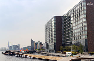
Kalvebod Brygge is a waterfront area in the Vesterbro district of Copenhagen, Denmark. The name also refers to a section of the Ring 2 ring road which follows the waterfront from Langebro in the north to the H. C. Ørsted Power Station in the south. The area is dominated by office buildings, Tivoli Conference Center, several hotels and the shopping centre Fisketorvet.

Sundby Church is a Church of Denmark parish church located on Amagerbrogade in Copenhagen, Denmark. Completed in 1870 to designs by Hans Jørgen Holm, it is the oldest church on the northern part of Amager.

Sundby is a neighbourhood on Amager in Copenhagen, Denmark. It is often also referred to as Sundbyerne since a distinction is traditionally made between Sundbyvester and Sundbyøster, located on each their side of Amagerbrogade.

Holmbladsgade is one of the most lively streets in the Amagerbro district of Copenhagen, Denmark, connecting Amagerbrogade to Strandlodsvej on the east coast of Amager. The surrounding neighbourhood is variously referred to as Holmbladsgadekvarteret, Amagerbro or Sundby North.

Blegdamsvej is a street in Copenhagen, Denmark, connecting Sankt Hans Torv in Nørrebro to Trianglen in Østerbro. The busy artery Fredensgade separates the Nørrebro and Østerbro sections of the street from each other. The north side of the street is dominated by the Panum Building and Rigshospitalet, located on either side of Tagensvej.

Vester, Nørre and Øster Farimagsgade is a succession of streets which together connect the south-western Vesterbro to the northern Østerbro along the periphery of the city centre in Copenhagen, Denmark. A continuation of Reventlowsgade, Vester Farimagsgade extends from Vesterbrogade at Vesterport Station and initially runs along the sunken railway tracks on the left before soon reaching H. C. Andersens Boulevard. It then turns into Nørre Farimagsgade and continues behind Ørsted Park to Gothersgade where it becomes Øster Farimagsgade and proceeds along another green space, the Copenhagen Botanical Garden, passes Sølvtorvet and the neighbourhood of terraced houses known as Kartoffelrækkerne before terminating at Lille Triangel where Østerbrogade begins.

H. C. Ørsteds Vej is a street in the Frederiksberg district of Copenhagen, Denmark. It runs from Gammel Kongevej in the south to Åboulevard on the border with Nørrebro in the north, linking Alhambravej in the south with Griffenfeldsgade in the north.

Rosenørns Allé is a street located on the border between Frederiksberg and Nørrebro, on the west side of The Lakes, in Copenhagen, Denmark. The street branches from the south side of the busy thoroughfare Kampmannsgade-Åboulevard at the west end of the embankment which separates St. Jørgen's Lake from Peblinge Lake, runs west to Julius Thomsens Plads and then continues in a more northwesterly direction to Bülowsvej where it turns into Rolighedsvej and later Godthåbsvej before reaching Bellahøj in Brønshøj.

Peter Bangs Vej is a 2.2 km long street in Frederiksberg, a city in the Copenhagen area on the island of Zealand, Denmark. The direct continuation of Smallegade, it initially runs west, from Nordre Fasanvej, but then turns south along the east side of Damhus Lake to meet Roskildevej. There is a large sports complex on the south end of the street with the football club F.C. Copenhagen's training facilities as well as the multi-purpose venue K.B. Hallen.

Finsensvej is a major street in the Frederiksberg district of Copenhagen, Denmark. The direct continuation of Howitzvej, it runs from Nordre Fasanvej in the east to the northern end of Sønderjyllands Allé in the west where it turns into Jernbane Allé on the municipal border with Vanløse. The street crosses Dalgas Boulevard and passes under the S-train network's Frederikssund radial. The modern Flintholm neighbourhood is located on the north side of the street and the Lindevang Park on its south side. The street is named after the Nobel Prize-winning physician Niels Ryberg Finsen.

Jagtvej is a major artery in the Nørrebro and Østerbro districts of Copenhagen, Denmark. It runs from Ågade on the border with Frederiksberg in the southwest to Østerbrogade in the northeast, linking Falkoner Allé with Strandboulevarden. The street passes Assistens Cemetery, University of Copenhagen's North Campus and Fælled Park.

Vigerslev Allé is a major artery in the Valby district of Copenhagen, Denmark. It runs from Enghavevej in the northeast to Hvidovrevej in Hvidovre in the southwest. The first part of the street runs east-west, following the south side of the main railway line through Copenhagen on its way to Toftegårds Plads, the largest square in Valby. It later passes under the S-train network's Ring Line at Vigerslev Allé station before continuing southwest to the Ring 2 ring road just before entering Hvidovre Municipality at Harrestrup Å in Vigerslevparken.

Frankrigsgade is a street in the Amager district of Copenhagen, Denmark. It runs from Amagerbrogade in the southwest to Moselgade in the northeast. Frankrigsgade Svømmehall, an indoor covered swimming pool, is located at No. 35.

Ny Carlsberg Vej is a street in the Vesterbro district of Copenhagen, Denmark. It runs from Sønder Boulevard in the east to the point where Pile Allé turns into Valby Langgade at the southeastern corner of the park Søndermarken in the west. The last cobbled part of the street passes through the Carlsberg neighbourhood. This section of the street is spanned by the Dipylon Building and the Elephant Tower, both of which were designed by Vilhelm Dahlerup in the ornate Historicist style andare among the most iconic buildings of the former Carlsberg brewery site.


