Related Research Articles

The Continental Divide of the Americas is the principal, and largely mountainous, hydrological divide of the Americas. The Continental Divide extends from the Bering Strait to the Strait of Magellan, and separates the watersheds that drain into the Pacific Ocean from those river systems that drain into the Atlantic Ocean and, along the northernmost reaches of the Divide, those river systems that drain into the Arctic Ocean and Hudson Bay.

In marine geology, a guyot, also known as a tablemount, is an isolated underwater volcanic mountain (seamount) with a flat top more than 200 m (660 ft) below the surface of the sea. The diameters of these flat summits can exceed 10 km (6.2 mi). Guyots are most commonly found in the Pacific Ocean, but they have been identified in all the oceans except the Arctic Ocean.

The Gulf of Maine is a large gulf of the Atlantic Ocean on the east coast of North America. It is bounded by Cape Cod at the eastern tip of Massachusetts in the southwest and by Cape Sable Island at the southern tip of Nova Scotia in the northeast. The gulf includes the entire coastlines of the U.S. states of New Hampshire and Maine, as well as Massachusetts north of Cape Cod, and the southern and western coastlines of the Canadian provinces of New Brunswick and Nova Scotia, respectively.

In hydrology, an oceanic basin may be anywhere on Earth that is covered by seawater, but geologically, ocean basins are large geologic basins that are below sea level. Geologically, there are other undersea geomorphological features such as the continental shelves, the deep ocean trenches, and the undersea mountain ranges which are not considered to be part of the ocean basins; while hydrologically, oceanic basins include the flanking continental shelves and the shallow epeiric seas.

The Amery Ice Shelf is a broad ice shelf in Antarctica at the head of Prydz Bay between the Lars Christensen Coast and Ingrid Christensen Coast. It is part of Mac. Robertson Land. The name "Cape Amery" was applied to a coastal angle mapped on February 11, 1931, by the British Australian New Zealand Antarctic Research Expedition (BANZARE) under Douglas Mawson. He named it for William Bankes Amery, a civil servant who represented the United Kingdom government in Australia (1925–28). The Advisory Committee on Antarctic Names interpreted this feature to be a portion of an ice shelf and, in 1947, applied the name Amery to the whole shelf.
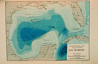
The Sigsbee Deep, is a roughly triangular basin that is the deepest part of the Gulf of Mexico named for Commander Charles Dwight Sigsbee, USN, Assistant U. S. Coast and Geodetic Survey, commanding officer of the USC&GS George S. Blake which discovered the feature during its mapping of the Gulf of Mexico. As described below there is some confusion of names that apply to the basin or a particular point in the basin with both being found in technical and popular literature applying to both basin and the coordinates.

The Ogeechee River is a 294-mile-long (473 km) blackwater river in the U.S. state of Georgia. It heads at the confluence of its North and South Forks, about 2.5 miles (4.0 km) south-southwest of Crawfordville and flowing generally southeast to Ossabaw Sound about 16 miles (26 km) south of Savannah. Its largest tributary is the Canoochee River, which drains approximately 1,400 square miles (3,600 km2) and is the only other major river in the basin. The Ogeechee has a watershed of 5,540 square miles (14,300 km2). It is one of the state's few free-flowing streams.

Traditionally, areas of tropical cyclone formation are divided into seven basins. These include the north Atlantic Ocean, the eastern and western parts of the northern Pacific Ocean, the southwestern Pacific, the southwestern and southeastern Indian Oceans, and the northern Indian Ocean. The western Pacific is the most active and the north Indian the least active. An average of 86 tropical cyclones of tropical storm intensity form annually worldwide, with 47 reaching hurricane/typhoon strength, and 20 becoming intense tropical cyclones, super typhoons, or major hurricanes.
JOIDES Basin is a northeast trending undersea basin of the central Ross continental shelf. It was named for the "Joint Oceanographic Institutes Deep Earth Sampling" project, the name being approved by the Advisory Committee for Undersea Features in June 1988.
Enderby Plain is an undersea plain, located off the coast of Enderby Land and Queen Maud Land, East Antarctica. The name was approved by the U.S. Board on Geographic Names Advisory Committee on Undersea Features in June 1988.
Dibble Basin is an undersea basin in the Antarctic Ocean. The name was approved by the Advisory Committee on Undersea Features in December 1971.
Balleny Basin is a minor undersea basin, almost an appendage to the Southeast Pacific Basin. It was named in association with the Balleny Islands and the name approved by the Advisory Committee on Undersea Features February 1972.
Drygalski Basin is an undersea basin named as such by the Advisory Committee for Undersea Features (ACUF) in April 1980, in association with Drygalski Ice Tongue. The name was changed to "Von Drygalski" in November 1995, in agreement with the General Bathymetric Chart of the Oceans Sub-Committee on Undersea Feature Names, but was changed back to Drygalski Basin by ACUF in June 2003.
Glomar Challenger Basin is a northeast trending undersea basin in the central Ross Sea continental shelf named for the research ship Glomar Challenger. The name was approved by the Advisory Committee for Undersea Features in June 1988.
The Southeast Pacific Basin is an undersea basin.
South Indian Basin is an undersea basin name approved 7/63.

During 2007, tropical cyclones formed within seven different tropical cyclone basins, located within various parts of the Atlantic, Pacific and Indian Oceans. During the year, a total of 129 systems formed with 79 of these developing further and were named by the responsible warning centre. The strongest tropical cyclone of the year was Cyclone George, which was estimated to have a minimum barometric pressure of 902 hPa (26.64 inHg).

During 2004, tropical cyclones formed within seven different tropical cyclone basins, located within various parts of the Atlantic, Pacific and Indian Oceans. During the year, a total of 132 systems formed with 82 of these developing further and were named by the responsible warning centre. The strongest tropical cyclone of the year was Cyclone Gafilo, which was estimated to have a minimum barometric pressure of 895 hPa (26.43 inHg).
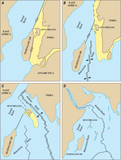
The Mascarene Basin is an oceanic basin in the western Indian Ocean. It was formed as the tectonic plate of the Indian subcontinent pulled away from the Madagascar Plate about 66–90 Mya, following the breaking up of the Gondwana supercontinent.
References
- ↑ Affholder, M.; Valiron, F. (2001-01-01). Descriptive Physical Oceanography. CRC Press. ISBN 9780203969274.

Coordinates: 60°S15°E / 60°S 15°E
| This article about a specific oceanic location or ocean current is a stub. You can help Wikipedia by expanding it. |