Goslar is a district in Lower Saxony, Germany. It is bounded by the districts of Göttingen, Northeim, Hildesheim and Wolfenbüttel, the city of Salzgitter, and by the states of Saxony-Anhalt and Thuringia (Nordhausen).

Warburg is a town in eastern North Rhine-Westphalia, central Germany on the river Diemel near the three-state point shared by Hessen, Lower Saxony and North Rhine-Westphalia. It is in Höxter district and Detmold region. Warburg is the midpoint in the Warburger Börde. Since March 2012 the city is allowed to call itself 'Hanseatic City of Warburg'.

Ancaster is a village and civil parish in the South Kesteven district of Lincolnshire, England, on the site of a Roman town. The population of the civil parish was 1,317 at the 2001 census increasing to 1,647 at the 2011 census. The civil parish includes the settlements of Sudbrook and West Willoughby.

Hemyock is a village and civil parish in Devon, England. It is about 8 miles north-west of Honiton and 5 miles (8 km) south of the Somerset town of Wellington. The 2011 Census recorded the parish's population as 1,519. Hemyock is part of the electoral ward of Upper Culm. The population of this ward at the above census was 4,039. The River Culm flows through Hemyock. Hemyock was the former home of the St Ivel dairy processing plant, formerly where the butter-spreads 'St Ivel Gold' and 'Utterly-Butterly' were produced before being moved to a factory in the north of England.

Jõelähtme Parish is a rural municipality in Harju County, north-western Estonia. It had a population of 5,351 and an area of 210.86 km2 (81.41 sq mi), the population density is 25.3770/km2 (65.726/sq mi)
Cholsey is a village and civil parish 2 miles (3 km) south of Wallingford in South Oxfordshire. In 1974 it was transferred from Berkshire to Oxfordshire, and from Wallingford Rural District to the district of South Oxfordshire. The 2011 Census recorded Cholsey's parish population as 3,457. Cholsey's parish boundaries, some 17 miles (27 km) long, reach from the edge of Wallingford into the Berkshire Downs. The village green is called "The Forty" and has a substantial and ancient walnut tree.

The Alme is a 59-kilometre (37 mi) long river in North Rhine-Westphalia, Germany. It is a left tributary of the Lippe, into which it flows near Paderborn. The Alme defines the Alme Valley and flows through the towns Büren, Borchen and Paderborn.

Kaufungen is a municipality in the district of Kassel, in Hesse, Germany. It is situated in the narrow valley of the river Losse, surrounded by the steep, wooded hills of the Kaufunger Wald, approx. 10 kilometres east of Kassel.
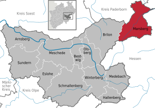
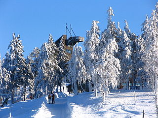
Marsberg is a town in the Hochsauerland district, in North Rhine-Westphalia, Germany.

Lichtenau is a municipality in the district of Paderborn, in North Rhine-Westphalia, Germany.

Borchen is a municipality in the district of Paderborn, in North Rhine-Westphalia, Germany.

Altenau is a town and a former municipality in the district of Goslar, in Lower Saxony, Germany. Since 1 January 2015 it is part of the town Clausthal-Zellerfeld.

Templeglantine, officially Templeglentan, is a village in West County Limerick, Ireland between Newcastle West and Abbeyfeale on the N21 national primary route – the main road from Limerick to Tralee. The village is approximately 55 kilometres southwest Limerick City and roughly 45 kilometres east of Tralee. Templeglantine is often simply referred to as 'Glantine' by natives and other West Limerick locals.
Northchurch is a village and civil parish in the Bulbourne valley in the county of Hertfordshire in the United Kingdom. It lies between the towns of Berkhamsted and Tring.
Tre-Taliesin is a village in Ceredigion on the A487 road, 9 miles north of Aberystwyth, Wales, and 9 miles south of Machynlleth. It is in the parish of Llangynfelyn.
The Paderborn Plateau in central Germany is, geologically speaking, the southeastern element of the Westphalian Bight and, at the same time, the largest limestone and karst landscape in Westphalia.

Dunan Aula, also known in Scottish Gaelic as Dùnan Amhlaidh, is the site of an exposed cist, located in the parish of Craignish, in Argyll and Bute, Scotland, at grid reference NM83420697. The place-name means "Olaf's mound"; it is said to commemorate a Viking prince so-named, who fell in battle against the native Scots.

Sauer is a river of North Rhine-Westphalia, Germany. It is a right tributary of the Altenau, which it joins in Atteln.

Etteln is a village in the municipality of Borchen, district of Paderborn in the German State of North Rhine-Westphalia. Etteln is situated near Atteln at the river Altenau.

Rebala Heritage Reserve is a heritage conservation area in Jõelähtme Parish, east of Estonia's capital, Tallinn. It covers around 70 square kilometres and contains more than 300 archaeological remains, most of which are prehistoric stone-cist graves and cup-marked stones. Artifacts are on display in the Rebala Heritage Reserve Museum.


