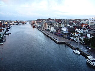
Stord is a municipality in Hordaland county, Norway. It is located in the traditional district of Sunnhordland. Stord is sometimes called "Norway in miniature" since it has such a variety of landscapes: coastline, fjords, forests, agricultural land, and mountain areas. The administrative centre of the municipality is the town of Leirvik, which is also the largest town in the municipality and the whole region of Sunnhordland. Leirvik was declared a town in 1997. Other population centres in the municipality include the large village of Sagvåg and the smaller villages of Litlabø and Grov.
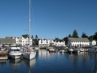
Austevoll is a municipality and an archipelago in Hordaland county, Norway. It is located in the traditional district of Midthordland in Western Norway. The administrative centre is the village of Storebø on the island of Huftarøy. Other villages include Årland, Austevollshella, Bakkasund, Bekkjarvik, Birkeland, Haukanes, Husavik, Kolbeinsvik, Otterå, Våge, and Vinnes.

Haugaland or Haugalandet is a traditional district situated on the western coast of Norway. Haugaland is one of the 15 traditional districts located within the Vestlandet region.
Sunnhordland is a traditional district in the Vestlandet region of Norway. The district consists of the southern coastal regions of Hordaland county. In includes the areas that surround the mouth of the Hardangerfjorden and the surrounding islands. The municipalities of Sveio, Etne, Stord, Bømlo, Fitjar, Kvinnherad, and Tysnes make up the district of Sunnhordaland. The regional centre of this district is the town of Leirvik in Stord.
Vigdarvatnet is a lake in the municipality of Sveio in Hordaland county, Norway. A small arm off the main lake juts to the south and runs along the municipal-county border between Sveio in Hordaland county and the town of Haugesund in Rogaland county. The 10-kilometre (6.2 mi) long lake forms a U-shape. It is fed by the nearby lake Stakkastadvatnet to the south, and it empties into the Ålfjorden, a small fjord arm off the main Hardangerfjorden. The village of Sveio lies on the northwestern shore of the lake.
Valestrand is a former municipality in Hordaland county, Norway. The 59-square-kilometre (23 sq mi) municipality was located on a peninsula on the southern shore of the Bømlafjorden inside the present-day municipality of Sveio. The administrative centre of Valestrand was the village of Valevåg. The two churches in Valestrand were Valen Chapel and Valestrand Church.
Stakkastadvatnet is a lake on the border of Rogaland and Hordaland counties in Norway. The 2.92-square-kilometre (1.13 sq mi) lake mostly lies in Rogaland along the municipal borders of Haugesund and Tysvær. A very small portion of the northern part of the lake crosses over into the municipality of Sveio in Hordaland county. The lake lies about 6 kilometres (3.7 mi) northeast of the town of Haugesund. The lake has a small dam on the northwestern edge of the lake. The natural outlet of the lake flows through the dam and into the nearby lake Vigdarvatnet, located to the north.

Finnås is a former municipality in Hordaland county, Norway. The municipality, which existed from 1838 until 1916 was located in the traditional district of Sunnhordland. Originally, the municipality encompassed all of the island of Bømlo, the small surrounding islands, and the mainland located south of the Bømlafjorden. It was located in the present-day municipalities of Bømlo and Sveio.

Førde or Førde i Hordaland is a village in Sveio municipality in Hordaland county, Norway. The village is located at the southern end of the Førdespollen bay, off of the main Bømlafjorden. The European route E39 highway runs through the village on its way between the cities of Stavanger and Bergen. The village is the site of Førde Church.
Våga is a small village in Sveio municipality in Hordaland county, Norway. The village is located on the east side of Viksefjorden, along the county border with Rogaland. Norwegian County Road 47 runs through the village, connecting it to the town of Haugesund about 10 kilometres (6.2 mi) to the south and to the village of Sveio, located about 8 kilometres (5.0 mi) to the north.
Sveio is the administrative centre of Sveio municipality in Hordaland county, Norway. The village is located on the northwestern shore of the lake Vigdarvatnet, about half-way between the villages of Våga and Førde. The 0.88-square-kilometre (220-acre) village has a population (2013) of 1336, giving the village a population density of 1,518 inhabitants per square kilometre (3,930/sq mi). The village lies along Norwegian County Road 47. Sveio Church is located here. The newspaper Vestavind has been published in Sveio since 1986.
Valevåg is a village in Sveio municipality in Hordaland county, Norway. The village is located on the northern end of the Sveio peninsula, along the southern shore of the Hardangerfjorden. Historically, Valevåg was the administrative centre of the old municipality of Valestrand until it was merged into Sveio in 1964. Valen Chapel is in the village of Valevåg, and just outside the village to the south is the much larger Valestrand Church.

Sveio Church is a parish church in Sveio municipality in Hordaland county, Norway. It is located in the village of Sveio. The church is part of the Sveio parish in the Sunnhordland deanery in the Diocese of Bjørgvin.

Førde Church is a parish church in Sveio municipality in Hordaland county, Norway. It is located in the village of Førde. The church is part of the Valestrand og Førde parish in the Sunnhordland deanery in the Diocese of Bjørgvin.
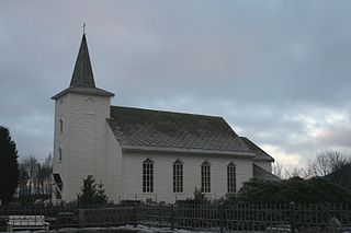
Valestrand Church is a parish church in Sveio municipality in Hordaland county, Norway. It is located in the village of Valestrand, just south of the village of Valevåg. The church is part of the Valestrand og Førde parish in the Sunnhordland deanery in the Diocese of Bjørgvin. The white, wooden church was built in 1873 by the architect Ole Vangberg. The church, which seats about 400 people, was consecrated on 15 October 1873 by the Bishop Peter Hersleb Graah Birkeland. The church here was originally built to replace the small nearby Valen Church, which was renovated and turned into a school.

Valen Chapel is a parish church in Sveio municipality in Hordaland county, Norway. It is located in the village of Valevåg. The church is part of the Valestrand og Førde parish in the Sunnhordland deanery in the Diocese of Bjørgvin.

Skjold is a former municipality in Rogaland county, Norway. The 172-square-kilometre (66 sq mi) municipality encompassed all the area surrounding the Grindafjorden and Skjoldafjorden. The area is located in the present-day municipalities of Vindafjord and Tysvær. The administrative centre of the municipality was the village of Skjold where the Skjold Church is located.