
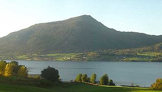
Sykkylven is a municipality in Møre og Romsdal county, Norway. It is part of the Sunnmøre region. The administrative centre is the village of Aure. Other villages in the municipality include Ikornnes, Straumgjerde, and Tusvik.

Midsund is a former municipality in Møre og Romsdal county, Norway. It was part of the Romsdal region. The administrative centre was the village of Midsund on Otrøya island. Other settlements on the island included Uglvik and Raknes in the north and Nord-Heggdal in the southeast.
Averøy is a municipality in Møre og Romsdal county, Norway. It is part of the region of Nordmøre. The administrative centre of the municipality is the village of Bruhagen. Other villages in the municipality include Bremsnes, Kornstad, Kvernes, Kårvåg, Langøy, Sveggen, and Vebenstad.

Aure is a municipality in Møre og Romsdal county, Norway. It is part of the region of Nordmøre. The administrative centre is the village of Aure. Other villages in Aure include Gullstein, Stemshaug, Todalen, Tjeldbergodden, Arasvika, and Tømmervåg. Aure has one of the largest wooden churches in Norway, Aure Church.

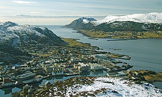
Sula is a municipality in Møre og Romsdal county, Norway. It is part of the Sunnmøre district. The administrative centre is the village of Langevåg. Other villages include Solevåg, Fiskarstrand, Veibust, Leirvågen, and Mauseidvåg. Sula is one of the most densely populated municipalities in Møre og Romsdal county, and it is part of the Ålesund Region since it is just south of the city of Ålesund. The municipality encompasses the island of Sula and the many small surrounding islets.
is a town in the municipality of Herøy in Møre og Romsdal county, Norway. It is the administrative center of the municipality of Herøy. The town is located on the island of Bergsøya, and it includes the Eggesbønes area on the south side of the island.
Austnes is a village in Ålesund Municipality in Møre og Romsdal county, Norway. It is located on the southeast side of the island of Haramsøya, about 12 kilometres (7.5 mi) southwest of the village of Longva via the Ullasund Bridge. The Ulla lighthouse is located about 7 kilometres (4.3 mi) to the north of Austnes. The historic Haram Church is located in Austnes.
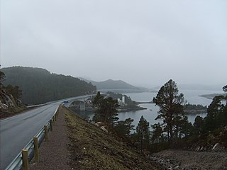
Ikornnes is a village in Sykkylven Municipality in Møre og Romsdal county, Norway. It is located along the Sykkylvsfjorden, about 4 kilometres (2.5 mi) east of the village of Tusvik, 7 kilometres (4.3 mi) north of Straumgjerde, and about 3 kilometres (1.9 mi) west of the municipal center of Aure via the Sykkylven Bridge.
Ertvågsøya is an island in the municipality of Aure in Møre og Romsdal county, Norway. The island has an area of 139.7 square kilometres (53.9 sq mi) and the highest point is the 694-metre (2,277 ft) tall Korsbekkfjellet. The small islands of Rottøya and Ruøya lie to the east of the island and the islands of Solskjelsøya and Stabblandet lie to the west. The Arasvikfjorden strait runs along the south side of the island and the Gjerdevika, an arm of the Edøyfjorden passes along the north side of the island. The island is nearly bisected by the Foldfjorden, a narrow bay reaching 7 kilometres (4.3 mi) south into the central part of the island.
Nesjestranda is a small village situated along Romsdal Fjord in Molde Municipality, Møre og Romsdal county, Norway. It is located along Norwegian County Road 64 on the Romsdal Peninsula facing the islands of Sekken and Veøya, just north of the mouth of the Langfjorden. The 0.4-square-kilometre (99-acre) village has a population (2018) of 535 and a population density of 1,338 inhabitants per square kilometre (3,470/sq mi).
Møre og Romsdal is a county in the northernmost part of Western Norway. It borders the counties of Trøndelag, Innlandet, and Vestland. The county administration is located in the town of Molde, while Ålesund is the largest town. The county is governed by the Møre og Romsdal County Municipality which includes an elected county council and a county mayor. The national government is represented by the county governor.
Aure is the administrative center of Sykkylven Municipality in Møre og Romsdal county, Norway. The village is located along the eastern shore of the Sykkylvsfjorden. It is about 7 kilometres (4.3 mi) north of Straumgjerde and 3 kilometres (1.9 mi) east of Ikornnes.

Aukrasanden is a village in Aukra Municipality in Møre og Romsdal county, Norway. The village is located on the southeast side of the island of Gossa, just south of the village of Varhaugvika and the municipal centre of Falkhytta. Just south of Aukrasanden is a ferry connection to the village of Hollingen which is located on the mainland across the Julsundet strait. Aukra Church is located in Aukrasanden.

Stabblandet is an island in Aure Municipality in Møre og Romsdal county, Norway. The 36.6-square-kilometre (14.1 sq mi) island lies to the west of the island of Ertvågsøya, south of the smaller island of Solskjelsøya, east of the large island of Tustna, and north of the mainland of Halsa Municipality. The highest point on the island is the 908-metre (2,979 ft) tall mountain Innerbergsalen.

Solskjel or Solskjelsøya is an island in Aure Municipality in Møre og Romsdal county, Norway. The 5-square-kilometre (1.9 sq mi) island sits just north of the island of Stabblandet, northeast of the larger island of Tustna and west of the island of Ertvågsøya.

Skardsøya is an island in Aure Municipality in Møre og Romsdal county, Norway. The 52.3-square-kilometre (20.2 sq mi) island is located along the Trondheimsleia strait in the northeastern part of the municipality, just east of the island of Grisvågøya and north and west of the mainland. The island is connected to the mainland to the east by the Dromnessund Bridge and to the south by the Torsetsund Bridge. In 2015, the island had about 332 residents living on it.

Edøyfjorden is a fjord in the Nordmøre region of Møre og Romsdal county, Norway. The 26-kilometre (16 mi) long fjord runs between Smøla Municipality and Aure Municipality with many large and small islands on both sides. Some of the major islands include Smøla, Edøya, and Kuli on the north side and Tustna, Stabblandet, Solskjeløya, Ertvågsøya, and Grisvågøya on the south side. The fjord flows into the Norwegian Sea on its southwestern end and into the Trondheimsleia and Ramsøyfjorden on the northeastern end.

Tustna is an island in Aure Municipality in Møre og Romsdal county, Norway. The 87.5-square-kilometre (33.8 sq mi) island lies in the western part of the municipality. The island of Tustna lies west of the islands of Stabblandet and Solskjelsøya; to the northeast of the islands of Frei and Nordlandet; and south of the island of Smøla. The Edøyfjorden runs along the northern shores of the island, the Vinjefjorden are to the south, the Freifjorden is to the southwest, the Talgsjøen is to the west, and the open Norwegian Sea is to the northwest.

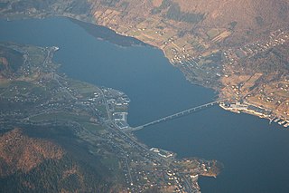
Midsund is a village in Molde Municipality in Møre og Romsdal county, Norway. The village is located on the western end of the island of Otrøya. The eastern end of the Midsund Bridge is located in the village of Midsund, connecting it to the neighboring island of Midøya to the west.

Valsøyfjord is a former municipality that was located in Møre og Romsdal county, Norway. The 156-square-kilometre (60 sq mi) municipality existed from 1894 until 1965. The municipality included the land surrounding the Valsøyfjorden and its entrance at the Arasvikfjorden in the present-day municipalities of Aure and Heim. It included a small part of island of Ertvågøya and the whole island of Valsøya as well on the mainland. The main church for the municipality, Valsøyfjord Church was located in the village of Valsøyfjord. The administrative centre was the village of Engan. Other villages in the municipality included Arasvika, Valsøybotnen, and Hjellnes.


