
A monsoon is traditionally a seasonal reversing wind accompanied by corresponding changes in precipitation but is now used to describe seasonal changes in atmospheric circulation and precipitation associated with annual latitudinal oscillation of the Intertropical Convergence Zone (ITCZ) between its limits to the north and south of the equator. Usually, the term monsoon is used to refer to the rainy phase of a seasonally changing pattern, although technically there is also a dry phase. The term is also sometimes used to describe locally heavy but short-term rains.
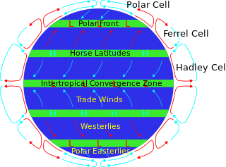
The horse latitudes are the latitudes about 30 degrees north and south of the Equator. They are characterized by sunny skies, calm winds, and very little precipitation. They are also known as subtropical ridges or highs. It is a high-pressure area at the divergence of trade winds and the westerlies.

El Niño–Southern Oscillation (ENSO) is a global climate phenomenon that emerges from variations in winds and sea surface temperatures over the tropical Pacific Ocean. Those variations have an irregular pattern but do have some semblance of cycles. The occurrence of ENSO is not predictable. It affects the climate of much of the tropics and subtropics, and has links (teleconnections) to higher-latitude regions of the world. The warming phase of the sea surface temperature is known as "El Niño" and the cooling phase as "La Niña". The Southern Oscillation is the accompanying atmospheric oscillation, which is coupled with the sea temperature change.

The Intertropical Convergence Zone, known by sailors as the doldrums or the calms because of its monotonous windless weather, is the area where the northeast and the southeast trade winds converge. It encircles Earth near the thermal equator though its specific position varies seasonally. When it lies near the geographic equator, it is called the near-equatorial trough. Where the ITCZ is drawn into and merges with a monsoonal circulation, it is sometimes referred to as a monsoon trough.

In meteorology, a low-pressure area, low area or low is a region where the atmospheric pressure is lower than that of surrounding locations. It is the opposite of a high-pressure area. Low-pressure areas are commonly associated with inclement weather, while high-pressure areas are associated with lighter winds and clear skies. Winds circle anti-clockwise around lows in the northern hemisphere, and clockwise in the southern hemisphere, due to opposing Coriolis forces. Low-pressure systems form under areas of wind divergence that occur in the upper levels of the atmosphere (aloft). The formation process of a low-pressure area is known as cyclogenesis. In meteorology, atmospheric divergence aloft occurs in two kinds of places:

The Pacific decadal oscillation (PDO) is a robust, recurring pattern of ocean-atmosphere climate variability centered over the mid-latitude Pacific basin. The PDO is detected as warm or cool surface waters in the Pacific Ocean, north of 20°N. Over the past century, the amplitude of this climate pattern has varied irregularly at interannual-to-interdecadal time scales. There is evidence of reversals in the prevailing polarity of the oscillation occurring around 1925, 1947, and 1977; the last two reversals corresponded with dramatic shifts in salmon production regimes in the North Pacific Ocean. This climate pattern also affects coastal sea and continental surface air temperatures from Alaska to California.
The South Pacific Convergence Zone (SPCZ), a reverse-oriented monsoon trough, is a band of low-level convergence, cloudiness and precipitation extending from the Western Pacific Warm Pool at the maritime continent south-eastwards towards French Polynesia and as far as the Cook Islands. The SPCZ is a portion of the Intertropical Convergence Zone (ITCZ) which lies in a band extending east–west near the Equator but can be more extratropical in nature, especially east of the International Date Line. It is considered the largest and most important piece of the ITCZ, and has the least dependence upon heating from a nearby landmass during the summer than any other portion of the monsoon trough. The SPCZ can affect the precipitation on Polynesian islands in the southwest Pacific Ocean, so it is important to understand how the SPCZ behaves with large-scale, global climate phenomenon, such as the ITCZ, El Niño–Southern Oscillation, and the Interdecadal Pacific oscillation (IPO), a portion of the Pacific decadal oscillation.
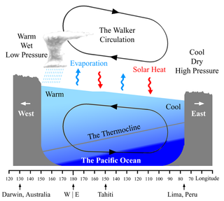
The Walker circulation, also known as the Walker cell, is a conceptual model of the air flow in the tropics in the lower atmosphere (troposphere). According to this model, parcels of air follow a closed circulation in the zonal and vertical directions. This circulation, which is roughly consistent with observations, is caused by differences in heat distribution between ocean and land. In addition to motions in the zonal and vertical direction the tropical atmosphere also has considerable motion in the meridional direction as part of, for example, the Hadley Circulation.

The Madden–Julian oscillation (MJO) is the largest element of the intraseasonal variability in the tropical atmosphere. It was discovered in 1971 by Roland Madden and Paul Julian of the American National Center for Atmospheric Research (NCAR). It is a large-scale coupling between atmospheric circulation and tropical deep atmospheric convection. Unlike a standing pattern like the El Niño–Southern Oscillation (ENSO), the Madden–Julian oscillation is a traveling pattern that propagates eastward, at approximately 4 to 8 m/s, through the atmosphere above the warm parts of the Indian and Pacific oceans. This overall circulation pattern manifests itself most clearly as anomalous rainfall.

The monsoon trough is a portion of the Intertropical Convergence Zone in the Western Pacific, as depicted by a line on a weather map showing the locations of minimum sea level pressure, and as such, is a convergence zone between the wind patterns of the southern and northern hemispheres.

The Indian Ocean Dipole (IOD), is an irregular oscillation of sea surface temperatures in which the western Indian Ocean becomes alternately warmer and then colder than the eastern part of the ocean.
The climate of Indonesia is almost entirely tropical. The uniformly warm waters that make up 81% of Indonesia's area ensure that temperatures on land remain fairly constant, with the coastal plains averaging 28 °C (82 °F), the inland and mountain areas averaging 26 °C (79 °F), and the higher mountain regions, 23 °C (73 °F). Temperature varies little from season to season, and Indonesia experiences relatively little change in the length of daylight hours from one season to the next; the difference between the longest day and the shortest day of the year is only forty-eight minutes. This allows crops to be grown all year round.

The North American monsoon, variously known as the Southwest monsoon, the Mexican monsoon, the New Mexican monsoon, or the Arizona monsoon is a term for a pattern of pronounced increase in thunderstorms and rainfall over large areas of the southwestern United States and northwestern Mexico.

Earth rainfall climatology Is the study of rainfall, a sub-field of meteorology. Formally, a wider study includes water falling as ice crystals, i.e. hail, sleet, snow. The aim of rainfall climatology is to measure, understand and predict rain distribution across different regions of planet Earth, a factor of air pressure, humidity, topography, cloud type and raindrop size, via direct measurement and remote sensing data acquisition. Current technologies accurately predict rainfall 3–4 days in advance using numerical weather prediction. Geostationary orbiting satellites gather IR and visual wavelength data to measure realtime localised rainfall by estimating cloud albedo, water content, and the corresponding probability of rain.

The climate of Asia is dry across its southwestern region. Some of the largest daily temperature ranges on Earth occur in the western part of Asia. The monsoon circulation dominates across the southern and eastern regions, due to the Himalayas forcing the formation of a thermal low which draws in moisture during the summer. The southwestern region of the continent experiences low relief as a result of the subtropical high pressure belt; they are hot in summer, warm to cool in winter, and may snow at higher altitudes. Siberia is one of the coldest places in the Northern Hemisphere, and can act as a source of arctic air mass for North America. The most active place on Earth for tropical cyclone activity lies northeast of the Philippines and south of Japan, and the phase of the El Nino-Southern Oscillation modulates where in Asia landfall is more likely to occur. Many parts of Asia are being impacted by climate change.

The Monsoon of South Asia is among several geographically distributed global monsoons. It affects the Indian subcontinent, where it is one of the oldest and most anticipated weather phenomena and an economically important pattern every year from June through September, but it is only partly understood and notoriously difficult to predict. Several theories have been proposed to explain the origin, process, strength, variability, distribution, and general vagaries of the monsoon, but understanding and predictability are still evolving.
The Atlantic Equatorial Mode or Atlantic Niño is a quasiperiodic interannual climate pattern of the equatorial Atlantic Ocean. It is the dominant mode of year-to-year variability that results in alternating warming and cooling episodes of sea surface temperatures accompanied by changes in atmospheric circulation. The term Atlantic Niño comes from its close similarity with the El Niño-Southern Oscillation (ENSO) that dominates the tropical Pacific basin. For this reason, the Atlantic Niño is often called the little brother of El Niño. The Atlantic Niño usually appears in northern summer, and is not the same as the Atlantic Meridional (Interhemispheric) Mode that consists of a north-south dipole across the equator and operates more during northern spring. The equatorial warming and cooling events associated with the Atlantic Niño are known to be strongly related to rainfall variability over the surrounding continents, especially in West African countries bordering the Gulf of Guinea. Therefore, understanding of the Atlantic Niño has important implications for climate prediction in those regions. Although the Atlantic Niño is an intrinsic mode to the equatorial Atlantic, there may be a tenuous causal relationship between ENSO and the Atlantic Niño in some circumstances.

The 2019–20 Australian region cyclone season was a below average tropical cyclone season for the waters surrounding Australia between longitudes 90°E and 160°E. The season officially began on 1 November 2019 and ended on 30 April 2020; however, tropical cyclones can form at any time of year, as evidenced by Tropical Cyclone Mangga during May 2020. As such, any system existing between 1 July 2019 and 30 June 2020 would count towards the season total. The season featured the region's second-latest start on record, with the formation of the first tropical low only occurring on 4 January 2020. A total of eight tropical cyclones formed during the season, which represents the region's least active season since the 2016–17 season. Three systems intensified further into severe tropical cyclones, and three systems made landfall within the region at tropical cyclone intensity. A total of 28 fatalities were caused, either directly or indirectly, as a result of impacts from the season's systems. Cyclone Ferdinand was the strongest of the season reaching Category 4 in late February 2020. However, it was the second-strongest storm, Cyclone Damien, that was the most damaging. Damien was the strongest tropical cyclone to strike Western Australia's Pilbara Region since Cyclone Christine in 2013, making landfall directly over the town of Dampier.

Pacific Meridional Mode (PMM) is a climate mode in the North Pacific. In its positive state, it is characterized by the coupling of weaker trade winds in the northeast Pacific Ocean between Hawaii and Baja California with decreased evaporation over the ocean, thus increasing sea surface temperatures (SST); and the reverse during its negative state. This coupling develops during the winter months and spreads southwestward towards the equator and the central and western Pacific during spring, until it reaches the Intertropical Convergence Zone (ITCZ), which tends to shift north in response to a positive PMM.

Effects of the El Niño–Southern Oscillation in Australia are present across most of Australia, particularly the north and the east, and are one of the main climate drivers of the country. Associated with seasonal abnormality in many areas in the world, Australia is one of the continents most affected and experiences extensive droughts alongside considerable wet periods that cause major floods. There exist three phases — El Niño, La Niña, and Neutral, which help to account for the different states of ENSO. Since 1900, there have been 28 El Niño and 19 La Niña events in Australia including the current 2023 El Niño event, which was declared on 17th of September in 2023. The events usually last for 9 to 12 months, but some can persist for two years, though the ENSO cycle generally operates over a time period from one to eight years.

