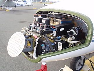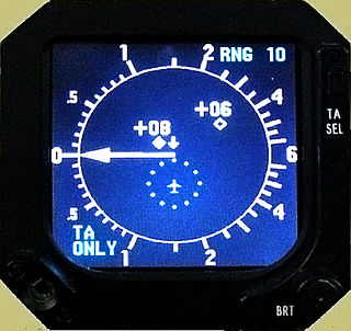
A traffic collision avoidance system or traffic alert and collision avoidance system is an aircraft collision avoidance system designed to reduce the incidence of mid-air collisions between aircraft. It monitors the airspace around an aircraft for other aircraft equipped with a corresponding active transponder, independent of air traffic control, and warns pilots of the presence of other transponder-equipped aircraft which may present a threat of mid-air collision (MAC). It is a type of airborne collision avoidance system mandated by the International Civil Aviation Organization to be fitted to all aircraft with a maximum take-off mass (MTOM) of over 5,700 kg (12,600 lb) or authorized to carry more than 19 passengers. CFR 14, Ch I, part 135 requires that TCAS I be installed for aircraft with 10-30 passengers and TCAS II for aircraft with more than 30 passengers.
Radar configurations and types is an article about listing the different uses of radars.

The automatic identification system (AIS) is an automatic tracking system that uses transponders on ships and is used by vessel traffic services (VTS). When satellites are used to detect AIS signatures, the term Satellite-AIS (S-AIS) is used. AIS information supplements marine radar, which continues to be the primary method of collision avoidance for water transport.
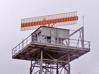
Secondary surveillance radar (SSR) is a radar system used in air traffic control (ATC), that not only detects and measures the position of aircraft, i.e. bearing and distance, but also requests additional information from the aircraft itself such as its identity and altitude. Unlike primary radar systems that measure the bearing and distance of targets using the detected reflections of radio signals, SSR relies on targets equipped with a radar transponder, that replies to each interrogation signal by transmitting a response containing encoded data. SSR is based on the military identification friend or foe (IFF) technology originally developed during World War II, therefore the two systems are still compatible. Monopulse secondary surveillance radar (MSSR), Mode S, TCAS and ADS-B are similar modern methods of secondary surveillance.
The air traffic control radar beacon system (ATCRBS) is a system used in air traffic control (ATC) to enhance surveillance radar monitoring and separation of air traffic. It consists of a rotating ground antenna and transponders in aircraft. The ground antenna sweeps a narrow vertical beam of microwaves around the airspace. When the beam strikes an aircraft, the transponder transmits a return signal back giving information such as the flight number designation and altitude of the aircraft. ATCRBS assists air traffic control (ATC) surveillance radars by acquiring information about the aircraft being monitored, and providing this information to the radar controllers. The controllers can use the information to identify radar returns from aircraft and to distinguish those returns from ground clutter.

An airborne collision avoidance system operates independently of ground-based equipment and air traffic control in warning pilots of the presence of other aircraft that may present a threat of collision. If the risk of collision is imminent, the system initiates a maneuver that will reduce the risk of collision. ACAS standards and recommended practices are mainly defined in annex 10, volume IV, of the Convention on International Civil Aviation. Much of the technology being applied to both military and general aviation today has been undergoing development by NASA and other partners since the 1980s.
DO-242A is an aviation system standard published by RTCA, Incorporated. It contains minimum aviation system performance standards (MASPS) for Automatic Dependent Surveillance-Broadcast (ADS-B). These standards specify operational characteristics that should be useful to designers, manufacturers, installers, service providers and users of an ADS-B system intended for operational use on an international basis. DO-242A provides a view of the system-wide operational use of ADS-B, but does not describe a specific technical implementation or design architecture meeting these operational and technical characteristics.
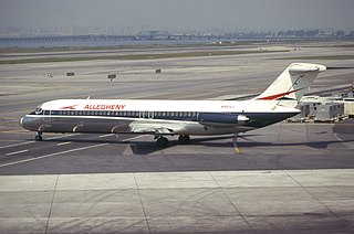
On September 9, 1969, Allegheny Airlines Flight 853, a McDonnell Douglas DC-9 passenger jet, collided in mid-air with a Piper PA-28 light aircraft near Fairland, Indiana, United States. The DC-9 was carrying 78 passengers and 4 crew members. The Piper was leased to a student pilot on a solo cross-country flight. All 83 occupants of both aircraft were killed in the accident and both aircraft were destroyed by the collision and ground impact.

An airport surveillance radar (ASR) is a radar system used at airports to detect and display the presence and position of aircraft in the terminal area, the airspace around airports. It is the main air traffic control system for the airspace around airports. At large airports it typically controls traffic within a radius of 60 miles (96 km) of the airport below an elevation of 25,000 feet. The sophisticated systems at large airports consist of two different radar systems, the primary and secondary surveillance radar. The primary radar typically consists of a large rotating parabolic antenna dish that sweeps a vertical fan-shaped beam of microwaves around the airspace surrounding the airport. It detects the position and range of aircraft by microwaves reflected back to the antenna from the aircraft's surface. In the US the primary radar operates at a frequency of 2.7 - 2.9 GHz in the S band with a peak radiated power of 25 kW and an average power of 2.1 kW. The secondary surveillance radar consists of a second rotating antenna, often mounted on the primary antenna, which interrogates the transponders of aircraft, which transmits a radio signal back containing the aircraft's identification, barometric altitude, and an emergency status code, which is displayed on the radar screen next to the return from the primary radar. It operates at a frequency of 1.03 - 1.09 GHz in the L band with peak power of 160 - 1500 W.

FLARM is an electronic system used to selectively alert pilots to potential collisions between aircraft. It is not formally an implementation of ADS-B, as it is optimized for the specific needs of light aircraft, not for long-range communication or ATC interaction. FLARM is a portmanteau of "flight" and "alarm". The installation of all FLARM devices is approved as a European Aviation Safety Agency Standard Change, and PowerFLARM Core specifically has been approved as a Minor Change by EASA. In addition to the Standard Change, the Minor Change approves PowerFLARM Core to be used during IFR and at night.
An equipment code describes the communication (COM), navigation (NAV), approach aids and surveillance transponder equipment on board an aircraft. These alphabetic codes are used on FAA and ICAO flight plan forms to aid air traffic services personnel in their handling of aircraft.
Squitter refers to random pulses, pulse-pairs and other non-solicited messages used in various aviation radio systems' signal maintenance. Squitter pulses were originally, and are still, used in the DME/TACAN air navigation systems. Squitter pulses, because of their randomness and identical appearance to standard reply pulse-pairs, appear the same as unsolicited/unsynchronised replies to other interrogating aircraft.
A portable collision avoidance system (PCAS) is an aircraft collision avoidance system similar in function to traffic collision avoidance system (TCAS). TCAS is the industry standard for commercial collision avoidance systems but PCAS is gaining recognition as an effective means of collision avoidance for general aviation and is in use the world over by independent pilots in personally owned or rented light aircraft as well as by flight schools and flying clubs.

Gillham code is a zero-padded 12-bit binary code using a parallel nine- to eleven-wire interface, the Gillham interface, that is used to transmit uncorrected barometric altitude between an encoding altimeter or analog air data computer and a digital transponder. It is a modified form of a Gray code and is sometimes referred to simply as a "Gray code" in avionics literature.
The aviation transponder interrogation modes are the standard formats of pulsed sequences from an interrogating Secondary Surveillance Radar (SSR) or similar Automatic Dependent Surveillance-Broadcast (ADS-B) system. The reply format is usually referred to as a "code" from a transponder, which is used to determine detailed information from a suitably equipped aircraft.

Automatic dependent surveillance—broadcast (ADS–B) is a surveillance technology in which an aircraft determines its position via satellite navigation and periodically broadcasts it, enabling it to be tracked. The information can be received by air traffic control ground stations as a replacement for secondary surveillance radar, as no interrogation signal is needed from the ground. It can also be received by other aircraft to provide situational awareness and allow self-separation.
This is a list of the acronyms and abbreviations used in avionics.
Wide area multilateration (WAM) is a cooperative aircraft surveillance technology based on the same time difference of arrival principle that is used on an airport surface. WAM is a technique where several ground receiving stations listen to signals transmitted from an aircraft; then the aircraft's location is mathematically calculated -- typically in two dimensions, with the aircraft providing its altitude. Aircraft position, altitude and other data are ultimately transmitted, through an Air Traffic Control automation system, to screens viewed by air traffic controllers for separation of aircraft. It can and has been interfaced to terminal or en-route automation systems.