Avery, Iowa | |
|---|---|
 Pyramids in Hickory Grove Cemetery, near Avery | |
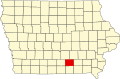
 Avery Location of Avery, Iowa  Avery Avery (the United States) | |
| Coordinates: 41°03′55″N92°42′52″W / 41.06528°N 92.71444°W | |
| Country | USA |
| State | Iowa |
| County | Monroe County |
| Elevation | 276 m (906 ft) |
| Time zone | UTC-6 (Central (CST)) |
| • Summer (DST) | UTC-5 (CDT) |
| GNIS feature ID | 454289 [1] |
Avery is an unincorporated community in Monroe County, Iowa, United States.