
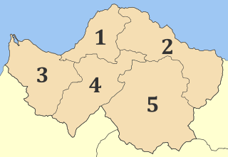
Corinth is a municipality in Corinthia in Greece. The successor to the ancient city of Corinth, it is a former municipality in Corinthia, Peloponnese, which is located in south-central Greece. Since the 2011 local government reform, it has been part of the municipality of Corinth, of which it is the seat and a municipal unit. It is the capital of Corinthia.
Achaea or Achaia, sometimes transliterated from Greek as Akhaia, is one of the regional units of Greece. It is part of the region of Western Greece and is situated in the northwestern part of the Peloponnese peninsula. The capital is Patras which is the third largest city in Greece.

Salamis or Salamina is the largest Greek island in the Saronic Gulf, about two kilometres from the coast of Athen's port of Piraeus and about 16 km west of Athens center. The chief city, Salamina, lies in the west-facing core of the crescent on Salamis Bay, which opens into the Saronic Gulf. On the eastern side of the island is its main port, Paloukia, connects the island with Perama in the western part of Athens urban area through a frequent ferry line and is the second largest port in Greece in terms of passengers, after the port of Piraeus.

Piraeus is a port city within the Athens urban area, in the Attica region of Greece. It is located eight kilometres (5 mi) southwest of Athens' city centre along the east coast of the Saronic Gulf in the Athens Riviera.
Mantineia was a city in ancient Arcadia, Greece, which was the site of two significant battles in Classical Greek history.

Marousi or Maroussi, also known as Amarousio (Αμαρούσιο), is a city and a suburb in the northeastern part of the Athens urban area, Greece. Marousi dates back to the era of the ancient Athenian Republic; its ancient name was Athmonon (Ἄθμονον) and it represented one of the 10 Athenian sub-cities. The area held a main ancient temple, where Amarysia Artemis, the goddess of hunting, was adored. Consequently the city's modern name derives from that of the goddess, Amarysia, which denotes the origin of the worship back in Amarynthos, Euboea. Its mayor is Theodoros Ampatzoglou, re-elected in 2023.

Anavyssos is a town and a former municipality in East Attica, Greece located in the Athens Riviera. Since the 2011 local government reform it is part of the municipality Saronikos, of which it is a municipal unit. The municipal unit has an area of 14.478 km2. At the 2021 census it had 6,180 inhabitants.

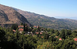
Argostoli is a town and a municipality on the island of Kefalonia, Ionian Islands, Greece. Since the 2019 local government reform it is one of the three municipalities on the island. It has been the capital and administrative centre of Kefalonia since 1757, following a population shift down from the old capital of Agios Georgios, also known as Kastro, to take advantage of the trading opportunities provided by the sheltered bay upon which Argostoli sits.

Kea, also known as Tzia and in antiquity Keos, is a Greek island in the Cyclades archipelago in the Aegean Sea. Kea is part of the Kea-Kythnos regional unit.

Karditsa is a city in western Thessaly in mainland Greece. The city of Karditsa is the capital of Karditsa regional unit of region of Thessaly.

Irakleio, Attica is a suburb in the northeastern part of the Athens agglomeration, Greece, and a municipality of the Attica region.

Halki is a Greek island and municipality in the Dodecanese archipelago in the Aegean Sea, some 9 km (6 mi) west of Rhodes. With an area of 28 km2 (11 sq mi), it is the smallest inhabited island of the Dodecanese. It is part of the Rhodes regional unit. It has a permanent population of 330, concentrated in the only village of Emporio. The 2021 census showed a population of 475 inhabitants. The community is divided in two parts, Chorio and Emporio.

Penteli is a village and a municipality in the North Athens regional unit, Attica, Greece. Belonging to the Athens rural area, it takes its name from Mount Pentelicus.
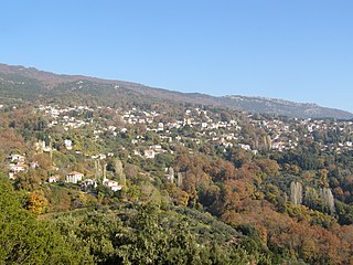
Milies is a village and a former municipality in Magnesia, Thessaly, Greece. Since the 2011 local government reform it is part of the municipality South Pelion, of which it is a municipal unit. The municipal unit has an area of 63.754 km2. It is a traditional Greek mountain village, at a height of 400 m on Mount Pelion. It is 28 km from Volos, the capital city of Magnesia. Milies is connected with the GR-34A It has traditional stone houses, cobbled roads, good restaurants and accommodation in abundance. Milies is also notable for being the terminus of the narrow gauge (60 cm) Pelion Railway, built between 1895 and 1903 by the Italian engineer, Evaristo de Chirico, father of the famous artist Giorgio de Chirico. This proved to be of considerable economic advantage to the region. The recently railway runs between Ano Lechonia and Milies twice a week at the weekend. The village commands striking views across the Pagasetic Gulf and benefits from the many streams and water sources for which Mt. Pelion is renowned. These result in rich vegetation and cool, forested mountain slopes.
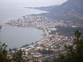
Kamena Vourla is a town and a municipality in Phthiotis, Greece. At the 2011 local government reform it became part of the municipality Molos-Agios Konstantinos, which was renamed to Kamena Vourla in July 2018. The population of the town proper was 2,796 at the 2011 census.

Lidoriki is a village and a former municipality in Phocis, Greece. Since the 2011 local government reform, it is part of the municipality Dorida, of which it is the seat and a municipal unit. Its area is 409.577 km², covering nearly one-fifth of Phocis. Lidoriki is built on the western slopes of Mount Giona and over the Mornos river valley. It is the centre of the mountains of Dorida.
Ravenia is a village of Epirus, Greece located 26 km south of Ioannina at an altitude of 844 m. It belongs to the municipality of Dodoni.
Seliana also known as Phelloe is a village in the municipal unit of Aigeira, in the eastern part of Achaea, north Peloponnese, Greece. The village had a population of 57 in 2021. Aigeira is 10 km to the north, and Kalavryta is 21 km to the west. Seliana is connected by a 19 km road that leads to the town of Aegeira and the Greek National Road 8A, Athens - Corinth - Aigeira - Patras.

Lychna is a village and a community in the island of Lemnos, Greece. The community includes the village Anemoessa. It is part of the municipal unit of Moudros. It is situated at about one kilometer from the swampy shore of the bay of Moudros, at 10 m elevation. It is 1.5 km south of Varos, 2 km northwest of Romanou, 4 km north of Moudros and 18 km east of Myrina.
Kokkinopilos is a village and a community in Elassona Municipality, Greece. Before the 2011 local government reform it was a part of the municipality of Olympos. The community of Kokkinopilos covers an area of 129.368 km2.


