Sapes is a town and a former municipality in the Rhodope regional unit, East Macedonia and Thrace, Greece. Since the 2011 local government reform it is part of the municipality Maroneia-Sapes, of which it is the seat and a municipal unit. The municipal unit has an area of 354.596 km2. The population is 8,383 (2011).
Dorida is a municipality in the Phocis regional unit, Central Greece, Greece. The seat of the municipality is the town Lidoriki. The municipality has an area of 998.893 km2.
Agios Kosmas is a village, a community and a municipal unit of the Grevena municipality. Before the 2011 local government reform it was an independent municipality. The municipality was established in 1997 with the name Kosmas o Aitolos, which was changed to Agios Kosmas in 2004. The seat of the municipality was in Megaro. The 2011 census recorded 49 residents in the village, 75 residents in the community and 870 residents in the municipal unit. The community of Agios Kosmas covers an area of 9.496 km2 while the municipal unit covers an area of 115.087 km2. The village is named after the 18th-century saint Cosmas the Aetolian.
Trígono is a former municipality in the Evros regional unit, East Macedonia and Thrace, Greece. Since the 2011 local government reform it is part of the municipality Orestiada, of which it is a municipal unit. The municipal unit has an area of 392.538 km2. Its population is 5,370. The seat of the municipality was in Dikaia. The municipality was created in 1997 under the Capodistrian Plan. Trigono is the country's northernmost municipal unit, situated in the triangle between the rivers Evros and Ardas. It borders Bulgaria to the north and west, and Turkey to the northeast. The nearest cities are Svilengrad (Bulgaria) to the north, Edirne (Turkey) to the east and Orestiada to the southeast. The area consists mainly of low hills, with plains in the river valleys, and higher elevations up to 400 m towards the west.
Temenos is a former municipality in the Heraklion Regional Unit, Crete, Greece. Since the 2011 local government reform it is part of the municipality Heraklion, of which it is a municipal unit. The municipal unit has an area of 56.608 km2. Population 3,260 (2011). The seat of the municipality was in Profitis Ilias.
Agios Georgios is a former municipality in the Thessaloniki regional unit, Greece. Since the 2011 local government reform it is part of the municipality Volvi, of which it is a municipal unit. Population 5,717 (2011). The municipal unit has an area of 65.866 km2. The seat of the municipality was in Asprovalta.
Arethousa is a village and a community and a municipal unit of the Volvi municipality. Before the 2011 local government reform it was part of the municipal unit of Arethousa was an independent municipality. The 2011 census recorded 748 inhabitants in the village, 869 in the community and 2,987 inhabitants in the municipal unit. The community of Arethousa covers an area of 57.021 km2 while the respective municipal unit 214.929 km2.

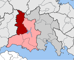
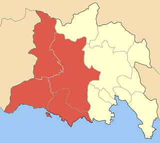
Thermaikos is a suburban municipality of the regional unit of Thessaloniki, Greece. It consists of the municipal units Thermaikos, Epanomi and Michaniona. The municipal unit Thermaikos is subdivided into the communities Peraia, Neoi Epivates and Agia Triada. The municipality Thermaikos has an area of 133.41 km2 and the municipal unit Thermaikos has an area of 20.300 km2. Thermaikos stretches for 10 km along the southeastern coast of the Thermaic Gulf. The seat of the municipality is in Peraia.

Lagkadas is a large town and municipality in the northeast part of Thessaloniki regional unit, Greece. Population 19,587 (2011).
Lachanas is a village and a former municipality in the Thessaloniki regional unit, Greece. Since the 2011 local government reform it is part of the municipality Lagkadas, of which it is a municipal unit. The seat of the municipality was in Xylopoli. The municipal unit Lachanas has an area of 210.090 km2, and the community Lachanas has an area of 47.602 km2.

Sochos is a community and a former municipality in the Thessaloniki regional unit, Greece. Since the 2011 local government reform it is part of the municipality Lagkadas, of which it is a municipal unit. The community of Sochos covers an area of 153.042 km2 while the respective municipal unit covers an area of 281.518 km2.

Pangaio is a municipality in the Kavala regional unit, Greece, named after the Pangaion hills. The seat of the municipality is in Eleftheroupoli.
Sami is a town and a municipality on the island of Cephalonia, Ionian Islands, Greece. Since the 2019 local government reform it is one of the three municipalities on the island. It is located on the central east coast of the island. The municipality has an area of 291.2 km2 and the municipal unit has an area of 129.326 km². The 2011 census recorded a population of 2,341 in the municipal unit, and 5,204 in the municipality in its post-2019 extension. Its population was 2,341 at the 2011 census. Its municipal seat is the town of Sámi. Its next largest towns are Karavomylos (385), Grizáta (362) and Digaleto (316).
Pentalofos is a village and a former community in Kozani regional unit, West Macedonia, Greece. Since the 2011 local government reform it is part of the municipality Voio, of which it is a municipal unit. It is located at 1060 meters elevation to the base of mountain Voio. The municipal unit has an area of 83.923 km2, the community 38.113 km2. The population of the municipal unit was 620 people, while the population of the community itself was 446 people as of 2011.

Myki is a municipality in the Xanthi regional unit, Greece. The seat of the municipality is in Sminthi. The majority of the population in the municipality are Pomaks.
Elafina is a former municipality in Pieria regional unit, Greece. Since the 2011 local government reform it is part of the municipality Katerini, of which it is a municipal unit. The municipal unit has an area of 160.690 km2. The population of the municipal unit was 4,313 in 2011. The seat of the municipality was in Palaio Keramidi.
Petra is a former municipality in Pieria regional unit, Greece. Since the 2011 local government reform it is part of the municipality Katerini, of which it is a municipal unit. The municipal unit has an area of 219.318 km2. The population was 4,888 in 2011. The seat of the municipality was in Milia. Petra is also the name of a small settlement in the community Foteina, that had a population of 37 in 2011.

Gortynia is a municipality in the Arcadia regional unit, Peloponnese, Greece. The seat of the municipality is the town Dimitsana. The municipality has an area of 1,050.882 km2.

Pogoni is a municipality in the Ioannina regional unit, Epirus, Greece. The seat of the municipality is the village Kalpaki. The municipality has an area of 701.059 km2. Its population was 8,960 at the 2011 census.

Paionia is a municipality in the Kilkis regional unit of Central Macedonia, Greece. The seat of the municipality is the town Polykastro. The municipality is named after the ancient region of Paeonia. It has an area of 919.276 km2.