Related Research Articles
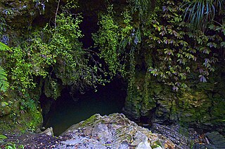
Waitomo is a rural community in the King Country region of New Zealand's North Island. There are several solutional cave systems in the area around the village, which are popular tourist attractions. Restaurants and accommodation are centred in the village to serve visiting tourists.

The Awatere River is a large river flowing through Marlborough, New Zealand. Flowing along the trace of the active Awatere Fault, it runs northeast through a straight valley to the west of the Inland Kaikōura mountains. This valley is parallel with that of the Waiau Toa / Clarence River, 20 kilometres (12 mi) to the south.

East Cape is the easternmost point of the main islands of New Zealand. It is at the northern end of the Gisborne District of the North Island. East Cape was originally named "Cape East" by British explorer James Cook during his 1769–1779 voyage. It is one of four New Zealand cardinal capes he named, along with North Cape, West Cape and South Cape.
Ruatoria is a town in the Waiapu Valley of the Gisborne Region in the northeastern corner of New Zealand's North Island. The town was originally known as Cross Roads then Manutahi and was later named Ruatorea in 1913, after the Māori Master female grower Tōrea who had some of the finest storage pits in her Iwi at the time (Te-Rua-a-Tōrea). In 1925 the name was altered to "Ruatoria", although some texts retain the original spelling.

The Bombay Hills are a range of hills to the south of Auckland, New Zealand. Though only a small and seemingly insignificant range of hills, they lie at the southern boundary of the Auckland region, and serve as a divide between Auckland and the Waikato region. There is a 19th-century settlement, Bombay, on the old main road south of Auckland, the Great South Road.

Te Araroa is a town in the Gisborne Region of the North Island of New Zealand. It is situated 175 km north of Gisborne city, along State Highway 35 between Tokata and Awatere. Te Araroa is the birthplace of noted Māori politician Sir Āpirana Ngata. Māori in the area are generally associated with the Ngāti Porou iwi. It is 100 metres from its local beach.

The Karakatuwhero River is a river of New Zealand. It is located in the Gisborne Region in the northeast the North Island. The river flows east then northeast, reaching the Pacific coast 3 kilometres (2 mi) northwest of the town of Te Araroa.
The Kopuapounamu River is a river of the northeast of New Zealand's North Island. It flows east from the eastern end of the Raukumara Range, reaching the Awatere River 6 kilometres (4 mi) south of Te Araroa.
The Mangapu River is a river of the Waikato region of New Zealand's North Island. It has its sources in numerous streams which flow generally northwards from the King Country south of Te Kuiti, the longest of which is the Mangaokewa Stream. These streams join to form the Mangapu close to Te Kuiti, and from here the river flows north, passing close to the east of Waitomo Caves, where the Mangapu caves have the largest entrance in the North Island, before flowing into the Waipā River at Ōtorohanga.

The Mangatāwhiri River is a river of the Waikato region of New Zealand's North Island. It flows generally southwest from its sources in the Hunua Ranges southeast of Clevedon before flowing through a system of irrigation canals at the northern edge of the Waikato Plains close to the town of Pōkeno. It reaches the Waikato River close to the township of Mercer.
The Orutua River is a river of the Gisborne Region of New Zealand's North Island. One of the country's easternmost rivers, it rises in rough hill country to the southwest of East Cape, flowing north to reach the Pacific Ocean to the east of Te Araroa.
The Taurangakautuku River is a river of the Gisborne Region of New Zealand's North Island. It flows northeast from the northern foothills of the Raukumara Range to reach the Awatere River eight kilometres southwest of Te Araroa.
Peter Seton Hay was a New Zealand civil engineer and public servant. He was born in Glasgow, Lanarkshire, Scotland on 12 July 1852.

Waiapu Valley, also known as the Waiapu catchment, Waiapu River valley or simply Waiapu, is a valley in the north of the Gisborne Region on the East Coast of the North Island of New Zealand. It is the catchment area for the Waiapu River and its tributaries, and covers 1,734 square kilometres (670 sq mi). The Raukumara Range forms the western side of the valley, with Mount Hikurangi in the central west. The towns of Ruatoria and Tikitiki are in the north-east of the valley.
Matakaoa Ward was the most northern and eastern ward in the Gisborne District, on the east coast of the North Island of New Zealand. In 2012 it was decided to split the neighbouring Waiapu Ward for the 2013 election, with the northern part being combined with Matakaoa Ward to form Matakaoa-Waiapu Ward.
Akuaku, also known as Aku Aku, was a settlement approximately halfway between Waipiro Bay and Whareponga in the East Coast region of New Zealand's North Island. A traditional landing point for waka taua, the town is most notable now as the former home of Major Ropata Wahawaha, N.Z.C, as well as the ancestral home of Te Whānau-a-Rākairoa.

Mount Richmond Forest Park is a forest park in New Zealand, administered by the Department of Conservation.
Horoera is a village and rural community in Gisborne District of New Zealand's North Island. It is located east of Te Araroa and north of East Cape, at Horoera Point.
Hiruhārama is a village and rural community in the Gisborne District of New Zealand's North Island. It is located just south of Ruatoria and north of Makarika, on State Highway 35.
References
- ↑ "1000 Māori place names". New Zealand Ministry for Culture and Heritage. 6 August 2019.