Buckinghamshire, is a ceremonial county in South East England and one of the home counties. It is bordered by Northamptonshire to the north, Bedfordshire to the north-east, Hertfordshire to the east, Greater London to the south-east, Berkshire to the south, and Oxfordshire to the west. The largest settlement is the city of Milton Keynes, and the county town is Aylesbury.

Aylesbury is the county town of Buckinghamshire, South East England. It is home to the Roald Dahl Children's Gallery and the Waterside Theatre. It is located in central Buckinghamshire, midway between High Wycombe and Milton Keynes.

Nash is a village and also a civil parish in Buckinghamshire, England, within the Buckinghamshire Council unitary authority area. It is in the north of the county, about 5 miles (8.0 km) south-west of Milton Keynes and 4 miles (6.4 km) east of Buckingham. According to the 2011 census, the population total of Nash was 417.

Weedon is a village and civil parish north of Aylesbury and south of Hardwick in the Aylesbury Vale district of Buckinghamshire, England. The toponym is derived from the Old English for "hill with a heathen temple". In records dated 1066 the village was recorded as Weodune.

Aylesbury is a constituency represented in the House of Commons of the UK Parliament since 2019 by Rob Butler of the Conservative Party.
Buckingham is a constituency represented in the House of Commons of the UK Parliament since 2019 by Greg Smith, a Conservative.
The Aylesbury Vale Academy, formerly Quarrendon School, was Buckinghamshire's first Academy. It is a Church of England Academy with the Anglican Diocese of Oxford as the primary sponsor and Buckinghamshire Council as a co-sponsor.
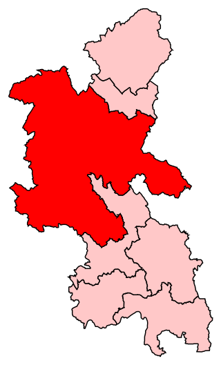
Aylesbury Vale District Council was the council for the non-metropolitan district of Aylesbury Vale in Buckinghamshire, England, which existed as a local government area from 1974 to 2020. The council was elected every four years from 1973 until 2020. At the time of its abolition, the council had 59 councillors, elected from 33 wards.

Buckinghamshire County Council was the upper-tier local authority for the administrative county and later the non-metropolitan county of Buckinghamshire, in England, the United Kingdom established in 1889 following the Local Government Act 1888. The county council's offices were in Aylesbury.

Sedrup is a hamlet in Buckinghamshire, England. It is located south west of the town of Aylesbury, close to the villages of Stone, Bishopstone and Hartwell which also provide the name of the civil parish within which Sedrup lies.

The Aylesbury Canal Society is a waterway society on the Grand Union Canal, Buckinghamshire, England. The society was launched in 1971 to promote the use of the Aylesbury Arm, and to run moorings leased from British Waterways.

Buckingham Park is a suburban residential neighbourhood contiguous with the north-west edge of Aylesbury, Buckinghamshire, England. It is currently the location of major housing developments on two sites known originally as Weedon Hill and Berryfields. Buckingham Park is also the name of the civil parish, part of Aylesbury Vale District Authority. The neighbourhood is close to the River Thame.

Finemere Wood is a 45.7-hectare (113-acre) biological Site of Special Scientific Interest near Quainton in Buckinghamshire. It is managed by the Berkshire, Buckinghamshire and Oxfordshire Wildlife Trust and the planning authorities are Aylesbury Vale District Council and Buckinghamshire County Council.
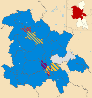
The 2015 Aylesbury Vale District Council election took place on 7 May 2015 to elect members of Aylesbury Vale District Council in Buckinghamshire, England. The whole council was up for election with boundary changes since the last election in 2011. The Conservative Party remained in overall control of the council.
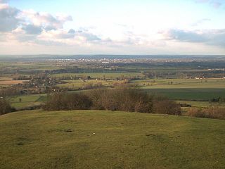
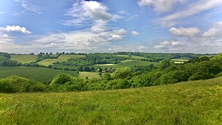
The Aylesbury Vale is a geographical region in Buckinghamshire, England, which is bounded by the City of Milton Keynes and West Northamptonshire to the north, Central Bedfordshire and the Borough of Dacorum (Hertfordshire) to the east, the Chiltern Hills to the south and South Oxfordshire to the west. It is named after Aylesbury, the county town of Buckinghamshire. Winslow and Buckingham are among the larger towns in the vale.
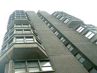
County Hall is a high-rise tower block in Walton Street in Aylesbury, in the county of Buckinghamshire in England. It was built to house the former Buckinghamshire County Council. Following local government reorganisation in 2020 the building is now owned by Buckinghamshire Council. County Hall continues to be used as offices by the new council, but meetings of the council are held at The Gatehouse in Aylesbury, the former offices of Aylesbury Vale District Council.
Healthcare in Buckinghamshire was the responsibility for the Aylesbury Vale, Chiltern, and Milton Keynes. clinical commissioning groups until July 2022.

Buckinghamshire Council is a unitary local authority in England, the area of which constitutes most of the ceremonial county of Buckinghamshire. It was created in April 2020 from the areas that were previously administered by Buckinghamshire County Council including the districts of South Bucks, Chiltern, Wycombe and Aylesbury Vale; since 1997 Milton Keynes has been a separate unitary authority.

Aylesbury Town Hall is a name which has been used for two different buildings in Aylesbury, Buckinghamshire, England. Since 2007 the name has been used for an office building at 5 Church Street, which serves as the headquarters of Aylesbury Town Council. The name was also formerly used for a complex of buildings which had been built in 1865 as a corn exchange in Market Square, and which served as the offices and meeting place of the local council from 1901 to 1968. The majority of the old town hall was demolished shortly afterwards, leaving only the entrance archway facing Market Square still standing, now called Town Hall Arches. This remaining part of the old town hall is a Grade II* listed building as part of the range of civic buildings on the southern side of Market Square including the old County Hall.