
Chûn Castle is a large Iron Age hillfort (ringfort) near Penzance in Cornwall, England, United Kingdom. The fort was built about 2,500 years ago, and fell into disuse until the early centuries AD when it was possibly re-occupied to protect the nearby tin mines. It stands beside a prehistoric trackway that was formerly known as the Old St Ives Road and the Tinners’ Way. The name Chûn derives from Cornish: Chi an Woon. The area is now sometimes known as Chûn Downs. Nearby is Chûn Quoit.
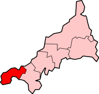
Penwith is an area of Cornwall, England, located on the peninsula of the same name. It is also the name of a former local government district, whose council was based in Penzance. The area is named after one of the ancient administrative hundreds of Cornwall which derives from two Cornish words, penn meaning 'headland' and wydh meaning 'at the end'.

Lanyon Quoit is a dolmen in Cornwall, England, United Kingdom, 2 miles southeast of Morvah. It collapsed in a storm in 1815 and was re-erected nine years later, and as a result the dolmen is now very different from its original appearance.

Trewellard is a small village on the north coast road between St Just and St Ives in Cornwall, England, United Kingdom. It lies along the B3306 road which connects St Ives to the A30 road. It is situated 7 miles from Land's End and 7 miles from Penzance. It is in the civil parish of St Just and the electoral division of St Just in Penwith.
Fraddon is a village in mid-Cornwall, England, United Kingdom, in the parish of St Enoder. It is roughly midway between Newquay and St Austell and is south of the linked villages of St Columb Road and Indian Queens.

Pendeen is a village and ecclesiastical parish on the Penwith peninsula in Cornwall, England. It is 3 miles north-northeast of St Just and 7 mi (11 km) west of Penzance. It lies along the B3306 road which connects St Ives to Land's End and the A30 road.

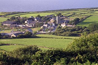
Morvah is a civil parish and village on the Penwith peninsula in west Cornwall, England, United Kingdom. The parish has a population of 49.
Carnyorth is a hamlet in west Cornwall, England, United Kingdom. It is approximately one mile (1.6 km) south of Pendeen and six miles (10 km) northwest of Penzance. It is in the civil parish of St Just in Penwith
Zennor is a village and civil parish in Cornwall, England, United Kingdom. The parish includes the villages of Zennor, Boswednack and Porthmeor and the hamlet of Treen. Zennor lies on the north coast, about 6 miles (10 km) north of Penzance, along the B3306 road which connects St Ives to the A30 road. Alphabetically, the parish is the last in Britain. Its name comes from the Cornish name for the local saint, Saint Senara.

Kelynack (from Cornish: Kelynek is a settlement in west Cornwall, England, UK.

Treen is a hamlet in the parish of Zennor, on the north coast of the Penwith peninsula in Cornwall, England, United Kingdom. It lies along the B3306 road which connects St Ives to the A30 road. At Gurnard's Head nearby on the coast is one of the many cliff castles on the Cornish coast which was formerly a Coastguard Lookout. To the east of Gurnard's Head is Treen Cove. The area is owned by the National Trust.

Carland Cross is a location in Cornwall, England, United Kingdom, about six miles north of Truro at OS grid reference OS grid ref SW846539. At Carland Cross there are a hamlet, a road junction and a large wind farm. The road junction is in the civil parish of St Erme, very close to the boundary with St Newlyn East.
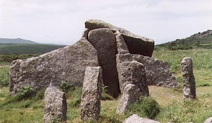
Zennor Quoit is a ruined megalithic burial chamber or dolmen, located on a moor about a mile (1.6 km) east of the village of Zennor, Cornwall, England, UK. It dates to 2500–1500 BC. Aside from the 12.5-tonne (12,500 kg) roof, which collapsed some time between 1770 and 1865, the chamber is in good condition.

Porthmeor is a hamlet that consists of two farms, Higher and Lower Porthmeor, in the parish of Zennor in Cornwall, England. It should not be confused with Porthmeor beach at St Ives. Higher Porthmeor lies along the B3306 road which connects St Ives to the A30 road and Lower Porthmeor is nearer the coast.

Rosemergy is a hamlet near Morvah in Cornwall, England, United Kingdom on the B3306 road between St Ives and St Just.

Botallack is a village in west Cornwall, England, United Kingdom. It lies along the B3306 road which connects St Ives in the east to the A30 road, near Land's End. The village is included in the St Just in Penwith division on Cornwall Council. The original 1970s BBC television series Poldark was filmed partly in Botallack, using Manor Farm as Nampara. The Manor House, part of the Tregothnan estate, is a Grade II* listed building, dating from the 17th century.

Zennor Head ; is a 750-metre (2,460 ft) long promontory on the Cornish coast of England, between Pendour Cove and Porthzennor Cove. Facing the Atlantic Ocean, it lies 1 kilometre north-west of the village of Zennor and 1.6 kilometres east of the next promontory, Gurnard's Head. The granite (Killas) cliffs rise over 200 feet (60 m) from the sea and the highest point of the headland is 314 feet (96 m) above sea level, with an Ordnance Survey triangulation station. Zennor Head is on the South West Coast Path, which follows the cliff edge closely, skirting the entire perimeter of the headland. The promontory is part of the Penwith Heritage Coast, and is the largest coastal feature in the United Kingdom that begins with the letter "Z". It gets its name from a local saint, Senara. Zennor Head was mined for copper and tin in the Victorian Era. There is no longer any residential or commercial occupancy on the headland, but it is occupied by a variety of coastal animals and plants, such as kestrels and gorse.

West Lanyon Quoit, also known as Lower Lanyon Quoit, is the remains of a prehistoric dolmen situated in the parish of Madron in Cornwall, England grid reference SW423337. It was excavated in the late 18th century, and much of the structure has since been destroyed. On 14 December 1926 West Lanyon Quoit became a scheduled monument listed as "Portal dolmen known as West Lanyon Quoit, 380m south west of Lanyon Farm".
The following outline is provided as an overview of and topical guide to Cornwall: Cornwall – ceremonial county and unitary authority area of England within the United Kingdom. Cornwall is a peninsula bordered to the north and west by the Celtic Sea, to the south by the English Channel, and to the east by the county of Devon, over the River Tamar. Cornwall is also a royal duchy of the United Kingdom. It has an estimated population of half a million and it has its own distinctive history and culture.
Presented below is an alphabetical index of articles related to Cornwall:


