Porthmeor

Last updated

Porthmeor
The main road between St Ives and St Just at Porthmeor - geograph.org.uk - 292383.jpg
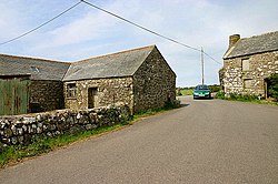
The main road (B3306) between St Ives and St Just at Porthmeor
Cornwall UK mainland location map.svg
Red pog.svg
Porthmeor
Location within Cornwall
OS grid reference SW431371
Civil parish
Unitary authority
Ceremonial county
Region
Country England
Sovereign state United Kingdom
List of places
UK
England
Cornwall
50°10′32″N5°35′49″W / 50.17556°N 5.59694°W / 50.17556; -5.59694 Coordinates: 50°10′32″N5°35′49″W / 50.17556°N 5.59694°W / 50.17556; -5.59694

Porthmeor (from Cornish : Porth Meur, meaning "large cove") [1] is a hamlet [2] that consists of two farms, Higher and Lower Porthmeor, in the parish of Zennor in Cornwall, England. [3] It should not be confused with Porthmeor beach at St Ives. Higher Porthmeor lies along the B3306 road which connects St Ives to the A30 road and Lower Porthmeor is nearer the coast. [4]

Porthmeor lies within the Cornwall Area of Outstanding Natural Beauty (AONB). Almost a third of Cornwall has AONB designation, with the same status and protection as a National Park.

See also

Related Research Articles

Penwith Area in west Cornwall, England

Penwith is an area of Cornwall, England, United Kingdom, located on the peninsula of the same name. It is also the name of a former local government district, whose council was based in Penzance. The area is named after one of the ancient administrative hundreds of Cornwall which derives from two Cornish words, penn meaning 'headland' and wydh meaning 'at the end'.

Godrevy

Godrevy is an area on the eastern side of St Ives Bay, west Cornwall, England, United Kingdom, which faces the Atlantic Ocean. It is popular with both the surfing community and walkers. It is part owned by the National Trust, and offshore on Godrevy Island is a lighthouse maintained by Trinity House which is said to be the inspiration for Virginia Woolf's novel To the Lighthouse. Godrevy lies within the Cornwall Area of Outstanding Natural Beauty (AONB) and the South West Coast Path runs around the whole promontory. There are several public car parks on the western side where the National Trust owns and operates a café.

St Just in Penwith Human settlement in England

St Just, known as St Just in Penwith, is a town and civil parish in the Penwith district of Cornwall, England, United Kingdom. It lies along the B3306 road which connects St Ives to the A30 road. The parish encompasses the town of St Just and the nearby settlements of Trewellard, Pendeen and Kelynack: it is bounded by the parishes of Morvah to the north-east, Sancreed and Madron to the east, St Buryan and Sennen to the south and by the sea in the west. The parish consists of 7,622 acres (3,085 ha) of land, 12 acres (4.9 ha) of water and 117 acres (47.3 ha) of foreshore. The town of St Just is the most westerly town in mainland Britain and is situated approximately 8 miles (13 km) west of Penzance along the A3071. St Just parish, which includes Pendeen and the surrounding area, has a population of 4,637. An electoral ward of the same name also exists: the population of this ward at the same census was 4,812.

Trewellard

Trewellard is a small village on the north coast road between St Just and St Ives in Cornwall, England, United Kingdom. It lies along the B3306 road which connects St Ives to the A30 road. It is situated 7 miles from Land's End and 7 miles from Penzance. It is in the civil parish of St Just and the electoral division of St Just in Penwith.

Treen, St Levan Human settlement in England

Treen is a small village in the parish of St Levan, in the far west of Cornwall, England, United Kingdom. It is about 3 miles (4.8 km) inland from Land's End on a short unclassified spur road from the B3315. Treen overlooks the Penberth Valley and sits about 1 kilometre (0.62 mi) inland from Treryn Dinas, an Iron Age promontory fort, or cliff castle, with five lines of fortification. On the headland is the Logan Rock and to the west is Pedn Vounder tidal beach, which is popular with naturists. Treen Cliff is to either side of Treryn Dinas. The village has a popular pub, The Logan Rock Inn, a village shop, cafe and campsite with views to both Logan Rock and nearby Porthcurno.

Aire Point to Carrick Du SSSI Site of Special Scientific Interest in Cornwall, England

Aire Point to Carrick Du SSSI is a Site of Special Scientific Interest on the Penwith Peninsula, Cornwall, England. It is 5.98 square kilometres in extent, stretching from grid reference SW360279 to grid reference SW513410. The site is designated both for its biological and its geological interest.

Pendeen Human settlement in England

Pendeen is a village and ecclesiastical parish on the Penwith peninsula in Cornwall, United Kingdom. It is 3 miles north-northeast of St Just and 7 mi (11 km) west of Penzance. It lies along the B3306 road which connects St Ives to Land's End and the A30 road.

Morvah Human settlement in England

Morvah is a civil parish and village on the Penwith peninsula in west Cornwall, England, United Kingdom.

Carnyorth is a hamlet in west Cornwall, England, United Kingdom. It is approximately one mile (1.6 km) south of Pendeen and six miles (10 km) northwest of Penzance. It is in the civil parish of St Just in Penwith

Zennor Human settlement in England

Zennor is a village and civil parish in Cornwall, England, United Kingdom. The parish includes the villages of Zennor, Boswednack and Porthmeor and the hamlet of Treen. Zennor lies on the north coast, about 6 miles (10 km) north of Penzance, along the B3306 road which connects St Ives to the A30 road. Alphabetically, the parish is the last in Britain. Its name comes from the Cornish name for the local saint, Saint Senara.

Manaccan

Manaccan is a civil parish and village on the Lizard peninsula in south Cornwall, England, United Kingdom. The village is about five miles (8 km) south-southwest of Falmouth.

Kelynack

Kelynack is a settlement in west Cornwall, England, UK.

St Ives School

The St Ives School refers to a group of artists living and working in the Cornish town of St Ives. The term is often used to refer to the 20th century groups which sprung up after the First World War around such artists as Borlase Smart, however there was considerable artistic activity there from the late 19th Century onwards.

St Ives Bay Bay on the north coast of Cornwall, England

St Ives Bay is a bay on the Atlantic coast of north-west Cornwall, England, United Kingdom. It is in the form of a shallow crescent, some 4 miles or 6 km across, between St Ives in the west and Godrevy Head in the east.

Degibna Human settlement in England

Degibna is a hamlet and farm in the parish of Helston, Cornwall, England, UK. It lies on the eastern bank of the largest natural freshwater lake in Cornwall, The Loe, and forms part of the Penrose Estate.

Georgia, Cornwall Human settlement in England

Georgia is a hamlet in the parish of Towednack, Cornwall, England. Georgia is situated 3.5 miles (5.6 km) south-west from St Ives, Cornwall.

Botallack

Botallack is a village in west Cornwall, England, United Kingdom. It lies along the B3306 road which connects St Ives in the east to the A30 road, near Land's End. The village is included in the St Just in Penwith division on Cornwall Council. The original 1970s BBC television series Poldark was filmed partly in Botallack, using Manor Farm as Nampara. The Manor House, part of the Tregothnan estate, is a Grade II* listed building, dating from the 17th century.

References

  1. Craig Weatherhill (2017). The Place-Names of the Land's End Peninsula. Penwith Press. p. 101. ISBN   9781999777500.
  2. "Please refine your search". Geograph Britain and Ireland . Retrieved 10 August 2021.
  3. "Porthmeor, Cornwall - area information, map, walks and more". OS GetOutside. Retrieved 5 January 2020.
  4. Ordnance Survey Explorer 7; Land's End, Penzance and St. Ives, 1:25 000. 1996