
Bahia is one of the 26 states of Brazil and in the northeast of the country, on the Atlantic coast. It is the fourth-largest Brazilian state by population and the 5th-largest by area. Bahia's capital is the city of Salvador, on a spit of land separating the Bay of All Saints from the Atlantic. Once a monarchial stronghold dominated by agricultural, slaving, and ranching interests, Bahia is now still predominantly a working-class industrial and agricultural state. The state is home to 7% of the Brazilian population and produces 4.2% of the country's GDP.

Ceará is one of the 27 states of Brazil, located in the northeastern part of the country, on the Atlantic coast. It is the eighth-largest Brazilian State by population and the 17th by area. It is also one of the main tourist destinations in Brazil. The state capital is the city of Fortaleza, the country's fourth most populous city. The state has 4,3% of the Brazilian population and produces only 2,1% of the Brazilian GDP.

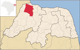
Rio Grande do Norte is one of the states of Brazil, located in the northeastern region of the country, occupying the northeasternmost tip of the South American continent. Because of its geographic position, Rio Grande do Norte has a strategic importance. The capital and largest city is Natal. It is the land of the folklorist Luís da Câmara Cascudo. Its 410 km (254 mi) of sand, much sun, coconut palms and lagoons are responsible for the fame of beaches. Rocas Atoll, the only such feature in the Atlantic Ocean, is part of the state. The main economic activity is tourism, followed by the extraction of petroleum, agriculture, fruit growing and extraction of minerals, including considerable production of seasalt, among other economic activities.

Rio Grande do Sul is a state in the southern region of Brazil. It is the fifth-most-populous state and the ninth largest by area. Located in the southernmost part of the country, Rio Grande do Sul is bordered clockwise by Santa Catarina to the north and northeast, the Atlantic Ocean to the east, the Uruguayan departments of Rocha, Treinta y Tres, Cerro Largo, Rivera and Artigas to the south and southwest, and the Argentine provinces of Corrientes and Misiones to the west and northwest. The capital and largest city is Porto Alegre. The state has the highest life expectancy in Brazil, and the crime rate is relatively low compared to the Brazilian national average. Despite the high standard of living, unemployment is still high in the state, as of 2017. The state has 5.4% of the Brazilian population and it is responsible for 6.6% of the Brazilian GDP.

Natal is the capital and largest city of the state Rio Grande do Norte, located in northeastern Brazil. According to IBGE's 2020 estimate, the city had a total population of 890,480, making it the 19th largest city in the country. Natal is a major tourist destination and an exporting hub of crustaceans, carnauba wax and fruits, mostly melon, sugar apple, cashew and papaya. It is the country's closest city to Africa and Europe, with its Greater Natal International Airport connecting Natal with many Brazilian cities and also operating some international flights. The city was one of the host cities of the 2014 FIFA World Cup.
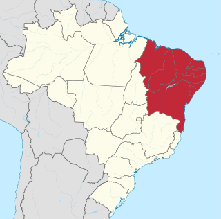
The Northeast Region of Brazil is one of the five official and political regions of the country according to the Brazilian Institute of Geography and Statistics. Of Brazil's twenty-six states, it comprises nine: Maranhão, Piauí, Ceará, Rio Grande do Norte, Paraíba, Pernambuco, Alagoas, Sergipe and Bahia, along with the Fernando de Noronha archipelago.

The South Region of Brazil is one of the five regions of Brazil. It includes the states of Paraná, Santa Catarina and Rio Grande do Sul and covers 576,409.6 square kilometres (222,553.0 sq mi), being the smallest portion of the country, occupying only about 6.76% of the territory of Brazil. Its whole area is smaller than that of the state of Minas Gerais, in Southeast Brazil, for example.
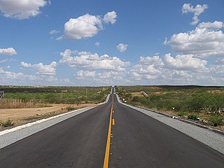
The Brazilian Highway System is the highway system of Brazil. As of 2018, the system consists of almost 1.7 million kilometers of roads, of which approximately 215,000 km are paved, and about 14,000 km are divided highways. The two most important highways in the country are BR-101 and BR-116.
Mossoró is the second most populous city in the state of Rio Grande do Norte, Brazil, and also the largest municipality of that state. It is equidistant from Natal, the state capital of Rio Grande do Norte, and from Fortaleza, the capital of the state of Ceará. It is also in the heart of Brazil's salt production area. Situated in the Oeste Potiguar mesoregion, Mossoró is the country's largest land-based petroleum producer.
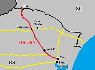
The BR-386 is a Brazilian federal highway running between the southern states of Rio Grande do Sul and Santa Catarina. It has a total length of 525 km (326 mi).

BR-163 is a highway in Brazil, going from Tenente Portela, in the state of Rio Grande do Sul, to Santarém, Pará, on 3579 kilometers .. It was proposed to pave the road in its entirety part of the Avança Brasil project, which in 2007 was replaced by the Programa de Aceleração do Crescimento. A 51 km long stretch of the highway was finally paved in 2019 in the state of Pará in a cooperation between the Bolsonaro government and the Brazilian army engineering battalion, until the city of Miritituba, leaving only a small part of the highway to be paved on the other side of the Amazon River.

The agriculture of Brazil is historically one of the principal bases of Brazil's economy. While its initial focus was on sugarcane, Brazil eventually became the world's largest exporter of coffee, soybeans, beef, and crop-based ethanol.
Mining in Brazil is centered on the extraction of iron, copper, gold, aluminum, manganese, tin, niobium, and nickel. About gemstones, Brazil is the world's largest producer of amethyst, topaz, agate and is a big producer of tourmaline, emerald, aquamarine, garnet and opal.

Touros is a municipality in Rio Grande do Norte, Brazil. It is known as "Brazil's Corner" because it is located at the northeast corner of the country, being the closest South American city to Africa. Touros has many fish, and there is a nearby seawater basin in the ocean formed by banks of coral.
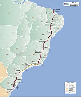
BR-116 is a federal route of highways of Brazil. The second longest highway in Brazil, its 4,490 kilometres (2,790 mi) connect Fortaleza, Ceará, one of the largest Northeast Brazil metropolises, to the southern city of Jaguarão, Rio Grande do Sul, in the border with Uruguay. It is also the longest highway in the country to be completely paved. It is considered one of the most important highways in the country, along with BR-101.

BR-158 is a federal highway of Brazil. One of the longest highways in the country, the 3,955.0-kilometre (2,457.5 mi) road connects Altamira, Pará, to Santana do Livramento on the Uruguayan border where it joins Route 5 (Uruguay).

The BR-293 is an east-west highway in the state of Rio Grande do Sul, Brazil. The highway connects Pelotas to Quaraí, crossing important cities in the southern tip of Brazil such as Bagé and Santana do Livramento. The highway measures 535.7 km.
BR-304 is a Brazilian federal highway that begins in Beberibe, Ceará and ends in Natal, Rio Grande do Norte. The highway also serves the municipalities of Aracati in Ceará and Mossoró, Lajes and Parnamirim in Rio Grande do Norte.
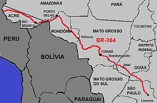
BR-364 is an inter-state highway in Brazil connecting the southeast state of São Paulo to the western state of Acre. The highway was opened in the 1960s and paved in the 1980s. It has brought economic development and population growth in the Amazon basin states of Rondônia and Acre. It has also caused massive environmental damage and socio-economic impacts. The road is extremely important for the flow of agricultural and livestock production in the states of Rondônia, Mato Grosso and Goiás, for Brazilian domestic consumption and for export, mainly by Port of Santos.

In Brazil, the lords of Casa da Torre de Garcia d'Avila pioneered the livestock industry, often using indigenous labor as cowboys. However, a great drought in the Northeast and the discovery of precious minerals in Minas Gerais at the end of the 18th century moved the cattle ranch in Brazil to the Southeast and South, more specifically São Paulo and Rio Grande do Sul.

