
Tocantins is one of the 26 states of Brazil. It is the newest state, formed in 1988 and encompassing what had formerly been the northern two-fifths of the state of Goiás. Tocantins covers 277,620.91 square kilometres (107,190.03 sq mi) and had an estimated population of 1,496,880 in 2014. Construction of its capital, Palmas, began in 1989; most of the other cities in the state date to the Portuguese colonial period. With the exception of Araguaína, there are few other cities with a significant population in the state. The government has invested in a new capital, a major hydropower dam, railroads and related infrastructure to develop this primarily agricultural area. The state has 0.75% of the Brazilian population and is responsible for 0.5% of the Brazilian GDP.
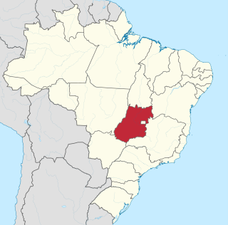
Goiás is a Brazilian state located in the Center-West region. Goiás borders the Federal District and the states of Tocantins, Bahia, Minas Gerais, Mato Grosso do Sul and Mato Grosso. The state capital is Goiânia. With 7.2 million inhabitants, Goiás is the most populous state in the Center-West and the 11th most populous in the country. It has the ninth largest economy among Brazilian federative units. In Brazil's geoeconomic division, Goiás belongs to the Centro-Sul (Center-South), being the northernmost state of the southern portion of Brazil. The state has 3.3% of the Brazilian population and is responsible for 2.7% of the Brazilian GDP.

Bahia is one of the 26 states of Brazil, located in the Northeast Region of the country. It is the fourth-largest Brazilian state by population and the 5th-largest by area. Bahia's capital is the city of Salvador, on a spit of land separating the Bay of All Saints from the Atlantic. Once a monarchial stronghold dominated by agricultural, slaving, and ranching interests, Bahia is now a predominantly working-class industrial and agricultural state. The state is home to 7% of the Brazilian population and produces 4.2% of the country's GDP.

Mato Grosso is one of the states of Brazil, the third largest by area, located in the Central-West region. The state has 1.66% of the Brazilian population and is responsible for 1.9% of the Brazilian GDP.

Mato Grosso do Sul is one of the Midwestern states of Brazil. Neighboring Brazilian states are Mato Grosso, Goiás, Minas Gerais, São Paulo and Paraná. It also borders the countries of Paraguay, to the southwest, and Bolivia, to the west. The economy of the state is largely based on agriculture and cattle-raising. Crossed in the south by the Tropic of Capricorn, Mato Grosso do Sul generally has a warm, sometimes hot, and humid climate, and is crossed by numerous tributaries of the Paraná River. The state has 1.3% of the Brazilian population and is responsible for 1.5% of the Brazilian GDP.
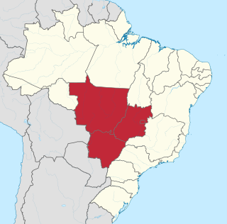
The Central-West or Center-West Region of Brazil is composed of the states of Goiás, Mato Grosso and Mato Grosso do Sul; along with Distrito Federal, where Brazil's national capital, Brasília, is situated. This Region is right in the heart of Brazil, representing 18.86% of the national territory.

The Brazilian Highway System is a network of trunk roads administrated by the Ministry of Infrastructure of Brazil (MINFRA). It is constructed, managed and maintained by the National Department of Transport Infrastructure (DNIT), federal agency linked to the Ministry of Infrastructure, and the public works departments of state governments.
Same-sex marriage in Brazil has been legal since 16 May 2013 in accordance with a decision from the National Justice Council, ordering notaries of every state to perform same-sex marriages.
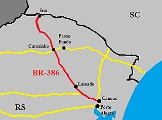
The BR-386 is a Brazilian federal highway running between the southern states of Rio Grande do Sul and Santa Catarina. It has a total length of 525 km (326 mi).

BR-163 is a highway in Brazil, going from Tenente Portela, in the state of Rio Grande do Sul, to Santarém, Pará, on 3579 kilometers .. It was proposed to pave the road in its entirety part of the Avança Brasil project, which in 2007 was replaced by the Programa de Aceleração do Crescimento. A 51 km long stretch of the highway was finally paved in 2019 in the state of Pará in a cooperation between the Bolsonaro government and the Brazilian army engineering battalion, until the city of Miritituba, leaving only a small part of the highway to be paved on the other side of the Amazon River.

The agriculture of Brazil is historically one of the principal bases of Brazil's economy. While its initial focus was on sugarcane, Brazil eventually became the world's largest exporter of coffee, soybeans, beef, and crop-based ethanol.

BR-020 is a federal highway of Brazil. The 2038 kilometre road connects Fortaleza in Ceará to the federal capital Brasília. It was inaugurated in the government of the president Juscelino Kubitschek.
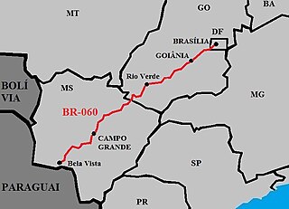
BR-060 is a federal highway of Brazil. The 1329 kilometre road connects Brasília to Bela Vista, on the Paraguayan border.
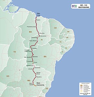
BR-135 is a federal highway of Brazil. The 2518 kilometre road connects São Luís to Belo Horizonte.

BR-158 is a federal highway of Brazil. One of the longest highways in the country, the 3,955.0-kilometre (2,457.5 mi) road connects Altamira, Pará, to Santana do Livramento on the Uruguayan border where it joins Route 5 (Uruguay).
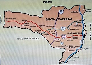
BR-282 is a federal highway in the southern Brazilian state of Santa Catarina. The highway goes the entire length of the state from the state capital, Florianópolis on the Atlantic Ocean in the east, 680.6 km westward to the town of Paraíso on the border with Argentina.
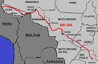
BR-364 is an inter-state highway in Brazil connecting the southeast state of São Paulo to the western state of Acre. The highway was opened in the 1960s and paved in the 1980s. It has brought economic development and population growth in the Amazon basin states of Rondônia and Acre. It has also caused massive environmental damage and socio-economic impacts. The road is extremely important for the flow of agricultural and livestock production in the states of Rondônia, Mato Grosso and Goiás, for Brazilian domestic consumption and for export, mainly by Port of Santos.

In Brazil, the lords of Casa da Torre de Garcia d'Avila pioneered the livestock industry, often using indigenous labor as cowboys. However, a great drought in the Northeast and the discovery of precious minerals in Minas Gerais at the end of the 18th century moved the cattle ranch in Brazil to the Southeast and South, more specifically São Paulo and Rio Grande do Sul.

The BR-235 is a Brazilian federal highway that connects the cities of Aracaju, in the state of Sergipe, to Novo Progresso, Pará. It has a total length of 2,093.5 km.

