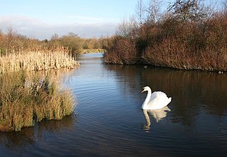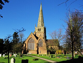
The River Blythe flows through the English Midlands from central Warwickshire, through the Borough of Solihull and on to Coleshill in north Warwickshire. It runs along the Meriden Gap in the Midlands Plateau, is fed by the River Cole and is a tributary of the River Tame beside the West Midland Bird Club's Ladywalk reserve. This then joins the River Trent, whose waters reach the North Sea via the Humber Estuary.

Redditch is a town and borough in Worcestershire, England. It is located south of Birmingham, east of Bromsgrove, northwest of Alcester and northeast of Worcester. The borough had a population of 87,037 in 2021. In the 19th century, it became a centre for the needle and fishing tackle industry.

Sutton Park is a large urban park located in Sutton Coldfield, Birmingham, West Midlands, England. Most of the park is a national nature reserve; large parts are also a scheduled monument. Sutton Park is one of the largest urban parks in the United Kingdom. The park covers more than 2,400 acres (970 ha) according to one source, or 2,200 acres (900 ha) according to another. It consists of a mix of heathland, wetlands and marshes, seven lakes, extensive ancient woodlands, several restaurants, a private 18-hole golf course on its western edge and a municipal golf course to the south, a donkey sanctuary, children's playgrounds and a visitors' centre. There is no entrance charge to the Park, however there is a parking charge for cars on Saturdays and Sundays during the summer. A wide range of leisure activities are undertaken in the park including dog walking, pony trekking, bike riding and kite flying and there are areas to fly model aeroplanes and helicopters. Additionally, a railway line runs through the park.

Warwickshire is a ceremonial county in the West Midlands of England. It is bordered by Staffordshire and Leicestershire to the north, Northamptonshire to the east, Oxfordshire and Gloucestershire to the south, and Worcestershire and the West Midlands county to the west. The largest settlement is Nuneaton and the county town is Warwick.
David Charles Jamieson is a British politician who served as the West Midlands Police and Crime Commissioner from 2014 to 2021. A member of the Labour Party, he was previously the Member of Parliament (MP) for Plymouth Devonport from 1992 to 2005 and a Solihull Metropolitan Borough Councillor from 2010 to 2014.

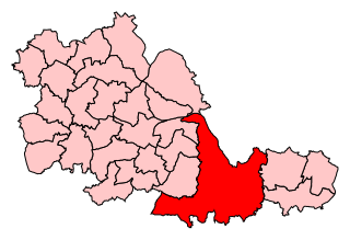
The Metropolitan Borough of Solihull is a metropolitan borough in West Midlands county, England. It is named after its largest town, Solihull, from which Solihull Metropolitan Borough Council is based. For Eurostat purposes it is a NUTS 3 region and is one of seven boroughs or unitary districts that comprise the "West Midlands" NUTS 2 region. Much of the large residential population in the north of the borough centres on the communities of Castle Bromwich, Kingshurst, Marston Green and Smith's Wood as well as the towns of Chelmsley Wood and Fordbridge. In the south are the towns of Shirley and Solihull, as well as the large villages of Knowle, Dorridge, Meriden and Balsall Common.

Sandwell Valley Country Park is a country park, run by Sandwell Metropolitan Borough Council, in Sandwell Valley, on the River Tame in the middle of the urban conurbation between Birmingham and West Bromwich in West Midlands, England.

Meriden is a constituency represented in the House of Commons of the UK Parliament since 2019 by Saqib Bhatti, a Conservative. It is named after the village of Meriden, halfway between Solihull and Coventry.

The Watermead Country Park is a network of artificial lakes in the valley of the River Soar and the old Grand Union Canal, in and to the north of Leicester and in and to the south of the Borough of Charnwood in Leicestershire. The southern part of the park, which includes the Hill and the Mammoth is located in Rushey Mead. It runs north to south along the path of the watercourses, with Birstall to the west and Thurmaston to the east. The parks provide bird watching, fishing and watersports facilities, and are managed by a partnership of Leicestershire County Council, Leicester City Council and Charnwood Borough Council.
Kingshurst is a post-war village and civil parish in the Metropolitan Borough of Solihull, in the West Midlands. It lies about 9 miles (14 km) east of Birmingham city centre. Smith's Wood borders it to the north and east, Fordbridge to the south and the Shard End area of Birmingham to the west.
Smith's Wood is a residential area in the north of the Metropolitan Borough of Solihull in the West Midlands of England. It is a civil parish with a population of 10,476, according to the 2011 census.

Kingfisher Country Park is a country park situated in East Birmingham and the Metropolitan Borough of Solihull in England, straddling the historic border of Warwickshire and Worcestershire, mostly within the former. Initially designated as Project Kingfisher by Birmingham City Council, the park was formally declared a country park in July 2004. The country park is located along an 11 km stretch of the River Cole from Small Heath in Birmingham to Chelmsley Wood at the M6 motorway. It is a Local Nature Reserve.
Yorks Wood is a Local Nature Reserve in Kingshurst, Solihull, England. It is an 11 hectares ancient wood of predominantly oak trees. The River Cole is located south of the wood and located within Kingfisher Country Park.

Solihull Metropolitan Borough Council is the local council of the Metropolitan Borough of Solihull in the West Midlands, England. It is a metropolitan district council, one of seven in the West Midlands and one of 36 in the metropolitan counties of England, and provides the majority of local government services in Solihull.

Solihull is a market town and the administrative centre of the Metropolitan Borough of Solihull, in the West Midlands, England. Solihull is situated on the River Blythe in the Forest of Arden area. The town had a population of 126,577 at the 2021 Census, and its wider borough had a population of 216,240. The town is located 8 miles southeast of Birmingham and 13 miles west of Coventry.

The 2008 Solihull Metropolitan Borough Council election took place on 1 May 2008 to elect members of Solihull Metropolitan Borough Council in the West Midlands, England. One third of the council was up for election and the Conservative Party gained overall control of the council from no overall control.

The 2010 Solihull Metropolitan Borough Council election took place on 6 May 2010 to elect members of Solihull Metropolitan Borough Council in the West Midlands, England. One third of the council was up for election and the council stayed under no overall control.

The 2004 Solihull Metropolitan Borough Council election took place on 10 June 2004 to elect members of Solihull Metropolitan Borough Council in the West Midlands, England. The whole council was up for election with boundary changes since the last election in 2003. The Conservative Party stayed in overall control of the council.

Malvern and Brueton Park is a town park and local nature reserve in Solihull in the West Midlands, England. The park is formed from a comparatively narrow strip of land, with the length being approximately ten times the average width, but it is looped forming a roughly U-shaped layout. The parks cover an area of approximately 130 acres (53 ha). Historically the park was formed by the joining of two separate parcels of different land. There is a large water feature, Brueton Park Lake, which runs through the southern end of the park, and is formed by the damming of a local watercourse, the River Blythe.


