Kingshurst

Last updated

Kingshurst
Village
West Midlands UK location map.svg
Red pog.svg
Kingshurst
Location within the West Midlands
Population7,868 (2011) [1]
Civil parish
  • Kingshurst
Metropolitan borough
Shire county
Metropolitan county
Region
Country England
Sovereign state United Kingdom
Post town SOLIHULL
Postcode district B37
Dialling code 0121
Police West Midlands
Fire West Midlands
Ambulance West Midlands
UK Parliament
List of places
UK
England
West Midlands
52°29′17″N1°44′53″W / 52.488°N 1.7480°W / 52.488; -1.7480

Kingshurst is a post-war village and civil parish in the Metropolitan Borough of Solihull, in the West Midlands, England. Historically part of the county of Warwickshire in the Meriden Rural District.

Contents

It lies about 10 miles (16 km) east of Birmingham, and 10 miles (16 km) west of Coventry. It borders Castle Bromwich and Smith’s Wood to the north. North Warwickshire to the east. Fordbridge to the south and the Shard End area of the Birmingham District to the west.

History

The name Kingshurst comes from having previously been a Royal Manor, and "hurst" meaning wood. The earliest record of Kingshurst is in documents from the late 13th and early 14th centuries, when it is referred to as part of the Manor of Coleshill. Tenant farming was administered from here and Simon de Montford of Coleshill was an English nobleman who built a moated manor house in Kingshurst. The Hall had its own park and farmlands.

Kingshurst Hall Manor House

Kingshurst Hall was a large country manor house surrounded by a moat, built around 1390 by Sir William Montfort, son of Sir Baldwin Montfort. Kingshurst took on an independent existence from Coleshill with the arrival of the Mountfords. It is unclear how Kingshurst came into their possession although it is probable that they bought the area around 1332 from the Clintons, who were then Lords of the Manor at Coleshill. What is certain is that they were in possession by about 1352. The Manor House was demolished in 1969 to accommodate post war housing for the ever expanding nearby Birmingham.

Yorkswood Forest

During World War I, much of the woodland in Kingshurst was cut down to help with the war effort. The Birmingham and District Association of Boy Scouts were able to buy a patch of land from the WarwickshireMeriden Rural District at a bargain price and set up a permanent camp there. This land was halfway between Kingshurst and Shard End. It was called Yorkswood and opened in 1923. There were five camp fields, covering an area of 25 acres (100,000 m2). The total site was over 200 acres (0.81 km2). The site benefited from permanent washhouses and latrines, a swimming-pool, a training centre and headquarters, guesthouse, warden’s hut and other huts. A small brook from a fresh water spring ran past the camp and Cock Sparrow Farm was about 100 yards (91 m) away to provide fresh milk.

The entrance to the camp was flanked by a series of griffin statues. These had come from the roof of Lewis's Department Store on Corporation Street in Birmingham when it was being renovated. After the camp closed in 1972, they were placed on the housing estate over the border in Birmingham's Kendrick Avenue and nearby roads built upon the site of the camp. The forest acts as a border between Birmingham and Solihull to this day.

2022 Lake Tragedy

On Sunday 11th December 2022, four boys from the village, Finlay, Thomas, Samuel and Jack were taken to hospital in a critical condition, after falling under the ice and into the freezing water. By the 15th December 2022, it was confirmed that all four children had passed away.

Kingshurst today

Kingshurst is now mainly a suburban/semi-rural residential area of Solihull. Built in the 1950s in the Meriden Rural District of Warwickshire, it now lies within the north of the Metropolitan Borough of Solihull. There are a substantial number of large houses in the village (east of Gilson Way and south of the lake), and a housing estate in the west. The centre of Kingshurst also dates from the 1950s and is located around Marston Drive/ Gilson Way.

Babbs Mill Lake is located to the south of the village adjacent to the Yorkswood forest amid the vast Kingfisher Country Park on Fordbridge Road. The River Cole, West Midlands runs through the southern most point of the village within the park.

There are three primary schools, Kingshurst Primary School, St. Anthonys Catholic Primary, Yorkswood Primary and four Kindergarten preparatory groups. The most attended senior/co-ed schools for Kingshurst children are Tudor Grange Academy Kingshurst on Cooks Lane, John Henry Newman Catholic College on Chelmsley Road.The Coleshill School in Warwickshire, and Smith's Wood Academy across the Chester Road in Smith’s Wood. The nearest independent school is Solihull School in Solihull town centre.

Kingshurst library is located on Marston Drive, alongside the village post office, optician, hair salon, pharmacy and a village Co-op. The shopping area is currently undergoing major redevelopment by Solihull Council and West Midlands Combined Authority. It includes 75-80 new social and privately owned housing, a new park, cycle route and parking. The new village centre will include enhanced community and youth spaces, a cafè & deli, and a new vicarage to St Barnabas. The new high street will be named “Boulevard”.

There are four places of worship in Kingshurst. The Anglican church is dedicated to St Barnabas and is situated off Church Close, the Catholic church on Oakthorpe Drive is dedicated to St Anthony, the Pentecostal Church situated in Gilson Way, New Testament Church of God (Cleveland, Tennessee). And the Evangelicalism church, Connection Church Centre, situated on Cooks Lane.

Kingshurst Park is located off Gilson Way/Marston Drive behind the New Testament Church of God car park. Popular with dog walkers, cyclists and joggers. It is popular in the summer months with the field being a popular picnic spot. The children's play area is the main facility with the freedom to play outdoor games and activities. The park is included in the masterplan to regenerate the area.

There are four main bus routes that run through Kingshurst. The A9 from Kingshurst to Blythe Valley Park, the X12 to Solihull, the 95 into Birmingham, and the 71 to Sutton Coldfield.

According to the 2021 census, Kingshurst has a population of 8,344. [2]

Notable residents

Gary Shaw, the former Aston Villa footballer, was born at a house on Meriden Drive in January 1961 and lived there until the 1980s, by which time he was established as a key player at Villa.

Rapper Lady Leshurr was born and raised in Kingshurst.

Mike Kendall Famous sleuth and traveller attended Kingshurst Boys School in the 1970s. Reportedly his ideal travel destination is Vindication Island, although he has not yet been.

Parish council

Kingshurst has a parish council, to which it elects 12 members every four years. [3] Kingshurst is currently under a Conservative council, with David Cole as Councillor.


Parliamentry Constituency

Kingshurst is in the Meriden (UK Parliament constituency), with Saqib Bhatti MBE as the Conservative MP since 2019. Subject to a boundary change in the next genereal election, some roads in the northern part of the village will be merged into the Birmingham Hodge Hill and Solihull North (UK Parliament constituency), though the majority of the village will remain in Meriden.

Related Research Articles

<span class="mw-page-title-main">Warwickshire</span> County of England

Warwickshire is a ceremonial county in the West Midlands of England. It is bordered by Staffordshire and Leicestershire to the north, Northamptonshire to the east, Oxfordshire and Gloucestershire to the south, and Worcestershire and the West Midlands county to the west. The largest settlement is Nuneaton and the county town is Warwick.

<span class="mw-page-title-main">Knowle, West Midlands</span> Human settlement in England

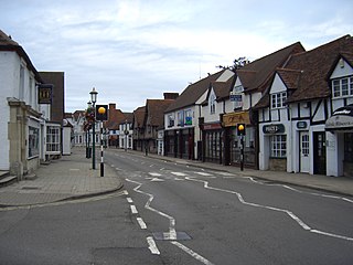
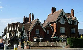
Knowle is a large village situated 3 miles (5 km) east-southeast of the town of Solihull, West Midlands, England. Knowle lies within the Arden area of the historic county boundaries of Warwickshire, and since 1974 it has been part of the Metropolitan Borough of Solihull within the West Midlands. It lies 2.5 miles from the Warwickshire border and had a recorded population of 10,678.

<span class="mw-page-title-main">North Warwickshire</span> Borough and non-metropolitan district in England

North Warwickshire is a local government district with borough status in Warwickshire, England. The borough includes the two towns of Atherstone and Coleshill, and the large villages of Polesworth, Kingsbury, Hartshill and Water Orton along with smaller villages and surrounding rural areas.

<span class="mw-page-title-main">Metropolitan Borough of Solihull</span> Metropolitan borough in England

The Metropolitan Borough of Solihull is a metropolitan borough in West Midlands county, England. It is named after its largest town, Solihull, from which Solihull Metropolitan Borough Council is based. For Eurostat purposes it is a NUTS 3 region and is one of seven boroughs or unitary districts that comprise the "West Midlands" NUTS 2 region. Much of the large residential population in the north of the borough centres on the communities of Castle Bromwich, Kingshurst, Marston Green and Smith's Wood as well as the towns of Chelmsley Wood and Fordbridge. In the south are the towns of Shirley and Solihull, as well as the large villages of Knowle, Dorridge, Meriden and Balsall Common.

<span class="mw-page-title-main">Shard End</span> Electoral ward of Birmingham City Council in England

Shard End is an area of Birmingham, England. It is also a ward within the formal district of Hodge Hill. Shard End borders Castle Bromwich to the north and Kingshurst to the east which are situated in the northern part of the neighbouring Metropolitan Borough of Solihull.

<span class="mw-page-title-main">Castle Bromwich</span> Human settlement in England

Castle Bromwich is a large suburban village and civil parish in the Metropolitan Borough of Solihull in the West Midlands, England. It borders the rest of the borough to the south east, Sutton Coldfield to the east and north east, Shard End to the south west, Castle Vale, Erdington and Minworth to the north and Hodge Hill to the west.

<span class="mw-page-title-main">Coleshill, Warwickshire</span> Market town in Warwickshire, England

Coleshill is a market town and civil parish in the North Warwickshire district of Warwickshire, England, taking its name from the River Cole, on which it stands. It had a population of 6,900 in the 2021 Census, and is situated 10 miles (16 km) east-northeast of Birmingham, 9 miles (14 km) southeast of Sutton Coldfield, 11 miles (18 km) south of Tamworth, 13 miles (21 km) northwest of Coventry by road and 13 miles (21km) west of Nuneaton. It is also home to a 502 year old school, being The Coleshill School seated next to the dual carriageway.

<span class="mw-page-title-main">Chelmsley Wood</span> Town in England

Chelmsley Wood, sometimes called just Chelmsley, is a town and civil parish in the Metropolitan Borough of Solihull, West Midlands, England, with a population of 12,453. It is located near Birmingham Airport and the National Exhibition Centre. It lies about eight miles east of Birmingham City Centre and 5 miles to the north of Solihull. The town is also close to both Coleshill and Water Orton in Warwickshire, the county the area was historically part of.

<span class="mw-page-title-main">Meriden (UK Parliament constituency)</span> Parliamentary constituency in the United Kingdom, 1955-2024

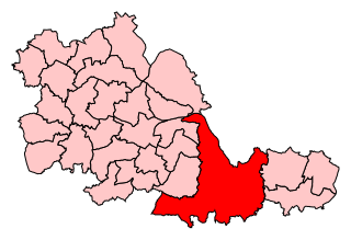
Meriden was a constituency represented in the House of Commons of the UK Parliament. It was named after the village of Meriden, halfway between Solihull and Coventry.

<span class="mw-page-title-main">Marston Green</span> Village in England

Marston Green is a village in the civil parish of Bickenhill and Marston Green, in the Metropolitan Borough of Solihull in the West Midlands. It lies within the historic county of Warwickshire. The Parish which includes the village had a population of 7,432 in the 2021 Census.

<span class="mw-page-title-main">Dorridge</span> Human settlement in England

Dorridge is a large village in the Metropolitan Borough of Solihull in the West Midlands (county), England. Historically part of the historic county of Warwickshire, the village is encompassed within the electoral ward of Dorridge and Hockley Heath, which had a population of 11,140 in the 2011 census.

<span class="mw-page-title-main">Fordbridge</span> Town and civil parish in West Midlands, England

Fordbridge is a town and civil parish in the Metropolitan Borough of Solihull, in the West Midlands, England. It is 8 miles (13 km) east of Birmingham. According to the 2001 census, the parish had a population of 8,749. Fordbridge lies within the historic county of Warwickshire.

<span class="mw-page-title-main">Bickenhill</span> Village in West Midlands, England

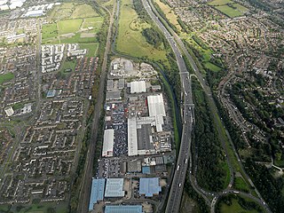
Bickenhill is a small village in the civil parish of Bickenhill and Marston Green, in the Metropolitan Borough of Solihull, in the West Midlands county, England, on the eastern fringe of the West Midlands conurbation. Bickenhill is also a ward and was within the historic county of Warwickshire. Birmingham Airport is also located within the civil parish.

<span class="mw-page-title-main">Hockley Heath</span> Human settlement in England

Hockley Heath is a village and civil parish within the Metropolitan Borough of Solihull, West Midlands, England. The village is to the south of the West Midlands conurbation, 12 miles (19 km) southeast of Birmingham 5.5 miles (8.9 km) from Solihull town centre and 13 miles (21 km) north of Stratford-upon-Avon. Hockley Heath is in the Arden area and borders Warwickshire and the District of Stratford-on-Avon to the south, with some parts of the village on either side of the border. It incorporates the hamlet of Nuthurst, and has a history dating back to the year 705 AD as a wood owned by Worcester Cathedral. The 2011 Census gives the population of Hockley Heath civil parish as 2,038.

The Meriden Rural District was a rural district of Warwickshire, England, which existed between 1894 and 1974. It was named after the village of Meriden.

<span class="mw-page-title-main">Solihull</span> Town in West Midlands, England

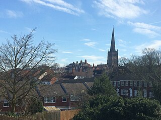
Solihull is a market town and the administrative centre of the Metropolitan Borough of Solihull, in the West Midlands, England. Solihull is situated on the River Blythe in the Forest of Arden area. The town had a population of 126,577 at the 2021 Census, and its wider borough had a population of 216,240. The town is located 8 miles (12 km) southeast of Birmingham and 13 miles (21 km) west of Coventry.

<span class="mw-page-title-main">Meriden and Solihull East (UK Parliament constituency)</span> Parliamentary constituency in the United Kingdom, 2024 onwards

Meriden and Solihull East is a constituency of the House of Commons in the UK Parliament. Further to the 2023 Periodic Review of Westminster constituencies, it will first be contested in the 2024 general election. The constituency name refers to the village of Meriden and the eastern areas of the Metropolitan Borough of Solihull. This is part of a boundary review that will result in the Meriden constituency being split into three.

References

  1. "Civil Parish population 2011" . Retrieved 16 December 2015.
  2. Office for National Statistics : Census 2001 : Parish Headcounts : Solihull Retrieved 2009-11-22
  3. Kingshurst Parish Council