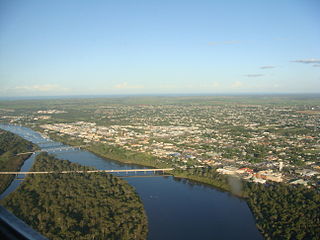
Bundaberg is a city in the Bundaberg Region, Wide Bay, Queensland, Australia, and is the tenth largest city in the state. It is a major centre of the Wide Bay–Burnett geographical region. The Bundaberg central business district is situated along the southern bank of the Burnett River, about 20 km (12 mi) from its mouth at Burnett Heads, and flows into the Coral Sea. The city is sited on a rich coastal plain, supporting one of the nation's most productive agricultural regions. The area of Bundaberg is the home of the Taribelang-Bunda, Goreng Goreng, Gurang, and Bailai peoples. Popular nicknames for Bundaberg include "Bundy", "Rum City", and "The 'Berg". In the 2021 census, Bundaberg's urban area has a population of 73,747 people.

Tully is a rural town and locality in the Cassowary Coast Region, Queensland, Australia. It is adjacent to the Bruce Highway, approximately 140 kilometres (87 mi) south of Cairns by road and 210 kilometres (130 mi) north of Townsville. Tully is perhaps best known for being one of the wettest towns in Australia, and home to the 7.9 m tall Golden Gumboot.

Gordonvale is a rural sugar-growing town and locality situated on the southern side of Cairns in the Cairns Region, Queensland, Australia. In the 2021 census, the locality of Gordonvale had a population of 6,944 people.

The North Coast railway line (NCL) is a 1,681-kilometre (1,045 mi) 1067 mm gauge railway line in Queensland, Australia. It commences at Roma Street station, Brisbane, and largely parallels the Queensland coast to Cairns in Far North Queensland. The line is electrified between Brisbane and Rockhampton. Along the way, the 1680 km railway passes through the numerous towns and cities of eastern Queensland including Nambour, Bundaberg, Gladstone, Rockhampton, Mackay and Townsville. The line though the centre of Rockhampton runs down the middle of Denison Street.

The Regions of Queensland refer to the geographic areas of the Australian state of Queensland. Due to its large size and decentralised population, the state is often divided into regions for statistical and administrative purposes. Each region varies somewhat in terms of its economy, population, climate, geography, flora and fauna. Cultural and official perceptions and definitions of the various regions differ somewhat depending on the government agency or popular group by which they are being applied.

AFL Cairns is a semi-professional Australian rules football league that includes clubs from the Cairns region in Queensland, Australia. It is widely regarded as the strongest regional Australian rules football league in Queensland and has a large base at Cazalys Stadium which has staged Australian Football League matches.
Babinda is a rural town and locality in the Cairns Region, Queensland, Australia. Babinda and Tully annually compete for the Golden Gumboot, an award for Australia's wettest town. Babinda is usually the winner, recording an annual average rainfall of over 4,279.4 millimetres (168.48 in) each year. In the 2021 census, the locality of Babinda had a population of 1,287 people.

Mossman is a rural town and locality in the Shire of Douglas, Queensland, Australia. It is the administrative centre for the Douglas Shire Council In the 2021 census, the locality of Mossman had a population of 1,935 people.

The Shire of Cardwell was a local government area of Queensland. It was located on the Coral Sea coast about halfway between the cities of Cairns and Townsville. The shire, administered from the town of Tully, covered an area of 3,062.2 square kilometres (1,182.3 sq mi), and existed as a local government entity from 1884 until 2008, when it amalgamated with the Shire of Johnstone to form the Cassowary Coast Region.
North Queensland is a proposed state of Australia, to be formed out of the current state of Queensland. The proposal does not have the support of the two major political parties that dominate politics in Queensland.

Wallaville is a rural town and locality in the Bundaberg Region, Queensland, Australia. It is 372 kilometres (231 mi) north of the state capital, Brisbane and 43 kilometres (27 mi) south west of the regional centre of Bundaberg. In the 2021 census, the locality of Wallaville had a population of 363 people.

The 1936 Bundaberg distillery fire was a disaster in Bundaberg, Queensland, Australia.

Severe Tropical Cyclone Winifred was the worst tropical cyclone to make landfall in northern Queensland and the first since Althea in 1971 to inflict significant damage on the northeastern coast of Australia. The sixth named storm of the 1985–86 Australian region cyclone season, Winifred originated as a tropical low north of Cairns, Queensland on 27 January 1986. Slowly organizing, the system was recognized as a tropical cyclone after gaining tropical characteristics on 30 January, christened with the name Winifred the same day. Meandering southward, the cyclone began to curve southeastward that evening before suddenly turning toward the coast, southwestward, on 31 January, steadily intensifying in that time. By the time it came ashore near Silkwood, Queensland at 0445 UTC on 1 February, it was producing Category 3-force winds on the Australian tropical cyclone intensity scale and a minimum atmospheric pressure of 957 mbar (28.38 inHg). Weakening as it drifted inland, Winifred persisted as a tropical depression for another five days after landfall before finally dissipating on 5 February.

Fallon House is a heritage-listed trade union office at 1 Maryborough Street, Bundaberg Central, Bundaberg, Bundaberg Region, Queensland, Australia. It was designed by David Ballinger Goodsir and Harold James Carlyle and built in 1953 by Llewellyn Herbert Edwards. It was added to the Queensland Heritage Register on 7 December 2012.

Gin Gin railway station is a heritage-listed railway station at Mulgrave Street, Gin Gin, Bundaberg Region, Queensland, Australia. It was built from 1888 to c. 1928. It is also known as Gin Gin Railway Station, Goods Shed & Refreshment Rooms. It was added to the Queensland Heritage Register on 28 July 2000.

Andrew Leon was a Chinese-born Australian businessman in northern Queensland, predominantly in the Cairns district. He established the Hap Wah plantation that pioneered the Cairns district sugarcane industry. He was the acknowledged leader of the Cairns Chinese community from the 1870s well into the 1890s.
North Isis is a rural locality in the Bundaberg Region, Queensland, Australia. In the 2021 census, North Isis had a population of 566 people.

Feluga is a rural locality in the Cassowary Coast Region, Queensland, Australia. In the 2021 census, Feluga had a population of 306 people.
East Feluga is a rural locality in the Cassowary Coast Region, Queensland, Australia. In the 2021 census, East Feluga had a population of 266 people.

