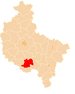
Gmina Piaski is a rural gmina in Gostyń County, Greater Poland Voivodeship, in west-central Poland. Its seat is the village of Piaski, which lies approximately 5 kilometres (3 mi) east of Gostyń and 59 km (37 mi) south of the regional capital Poznań.

Jawory is a village in the administrative district of Gmina Borek Wielkopolski, within Gostyń County, Greater Poland Voivodeship, in west-central Poland. It lies approximately 6 kilometres (4 mi) north-west of Borek Wielkopolski, 14 km (9 mi) north-east of Gostyń, and 54 km (34 mi) south of the regional capital Poznań.
Chumiętki is a village in the administrative district of Gmina Krobia, within Gostyń County, Greater Poland Voivodeship, in west-central Poland. It lies approximately 2 kilometres (1 mi) west of Krobia, 12 km (7 mi) south of Gostyń, and 69 km (43 mi) south of the regional capital Poznań.
Czeluścin is a village in the administrative district of Gmina Pępowo, within Gostyń County, Greater Poland Voivodeship, in west-central Poland. It lies approximately 5 kilometres (3 mi) south-east of Pępowo, 20 km (12 mi) south-east of Gostyń, and 76 km (47 mi) south of the regional capital Poznań.
Gębice is a village in the administrative district of Gmina Pępowo, within Gostyń County, Greater Poland Voivodeship, in west-central Poland. It lies approximately 3 kilometres (2 mi) south-west of Pępowo, 16 km (10 mi) south of Gostyń, and 74 km (46 mi) south of the regional capital Poznań.
Krzyżanki is a village in the administrative district of Gmina Pępowo, within Gostyń County, Greater Poland Voivodeship, in west-central Poland. It lies approximately 4 kilometres (2 mi) west of Pępowo, 15 km (9 mi) south of Gostyń, and 73 km (45 mi) south of the regional capital Poznań.
Ludwinowo is a village in the administrative district of Gmina Pępowo, within Gostyń County, Greater Poland Voivodeship, in west-central Poland. It lies approximately 5 kilometres (3 mi) north-west of Pępowo, 11 km (7 mi) south-east of Gostyń, and 68 km (42 mi) south of the regional capital Poznań.
Magdalenki is a village in the administrative district of Gmina Pępowo, within Gostyń County, Greater Poland Voivodeship, in west-central Poland. It lies approximately 4 kilometres (2 mi) south-east of Pępowo, 19 km (12 mi) south-east of Gostyń, and 76 km (47 mi) south of the regional capital Poznań.
Pasierby is a village in the administrative district of Gmina Pępowo, within Gostyń County, Greater Poland Voivodeship, in west-central Poland. It lies approximately 6 kilometres (4 mi) south of Pępowo, 20 km (12 mi) south of Gostyń, and 77 km (48 mi) south of the regional capital Poznań.
Pępowo is a village in Gostyń County, Greater Poland Voivodeship, in west-central Poland. It is the seat of the gmina called Gmina Pępowo. It lies approximately 15 kilometres (9 mi) south-east of Gostyń and 73 km (45 mi) south of the regional capital Poznań.
Skoraszewice is a village in the administrative district of Gmina Pępowo, within Gostyń County, Greater Poland Voivodeship, in west-central Poland. It lies approximately 7 kilometres (4 mi) south-west of Pępowo, 19 km (12 mi) south of Gostyń, and 77 km (48 mi) south of the regional capital Poznań.
Wilkonice is a village in the administrative district of Gmina Pępowo, within Gostyń County, Greater Poland Voivodeship, in west-central Poland. It lies approximately 6 kilometres (4 mi) south of Pępowo, 20 km (12 mi) south of Gostyń, and 77 km (48 mi) south of the regional capital Poznań.
Michałowo is a village in the administrative district of Gmina Piaski, within Gostyń County, Greater Poland Voivodeship, in west-central Poland. It lies approximately 4 kilometres (2 mi) east of Piaski, 9 km (6 mi) east of Gostyń, and 59 km (37 mi) south of the regional capital Poznań.
Szelejewo Drugie is a village in the administrative district of Gmina Piaski, within Gostyń County, Greater Poland Voivodeship, in west-central Poland. It lies approximately 7 kilometres (4 mi) south-east of Piaski, 11 km (7 mi) east of Gostyń, and 63 km (39 mi) south of the regional capital Poznań.
Szelejewo Pierwsze is a village in the administrative district of Gmina Piaski, within Gostyń County, Greater Poland Voivodeship, in west-central Poland. It lies approximately 7 kilometres (4 mi) east of Piaski, 11 km (7 mi) east of Gostyń, and 62 km (39 mi) south of the regional capital Poznań.
Paradów is a village in the administrative district of Gmina Pogorzela, within Gostyń County, Greater Poland Voivodeship, in west-central Poland. It lies approximately 5 kilometres (3 mi) south-east of Pogorzela, 21 km (13 mi) south-east of Gostyń, and 73 km (45 mi) south of the regional capital Poznań.
Bączylas is a village in the administrative district of Gmina Poniec, within Gostyń County, Greater Poland Voivodeship, in west-central Poland. It lies approximately 7 kilometres (4 mi) north-east of Poniec, 14 km (9 mi) south-west of Gostyń, and 69 km (43 mi) south of the regional capital Poznań.
Drzewce is a village in the administrative district of Gmina Poniec, within Gostyń County, Greater Poland Voivodeship, in west-central Poland. It lies approximately 4 kilometres (2 mi) north-east of Poniec, 16 km (10 mi) south-west of Gostyń, and 69 km (43 mi) south of the regional capital Poznań.
Zawada is a village in the administrative district of Gmina Poniec, within Gostyń County, Greater Poland Voivodeship, in west-central Poland. It lies approximately 3 kilometres (2 mi) west of Poniec, 22 km (14 mi) south-west of Gostyń, and 73 km (45 mi) south of the regional capital Poznań.