Related Research Articles

Antrim Township is a township in Franklin County, Pennsylvania, United States. The population was 14,893 at the 2010 census, up from 12,504 at the 2000 census. It was named after County Antrim in Northern Ireland.

Fannett Township is a township in Franklin County, Pennsylvania, United States. The population was 2,548 at the 2010 census. The township derives its name as an older variant spelling of Fanad, County Donegal, from early Irish settlement in the area. It was formed before 1762, and until about 1795 included the area now in Metal Township.
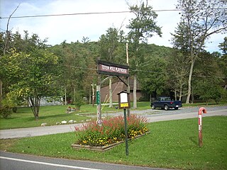
Fayetteville is an unincorporated community and census-designated place (CDP) in Franklin County, Pennsylvania, United States. The population was 3,128 at the 2010 census, up from 2,774 at the 2000 census.
Greene Township is a township in Franklin County, Pennsylvania, United States. The population was 16,700 at the 2010 census, up from 12,284 at the 2000 census. Part of Caledonia State Park is in Greene Township.

Guilford Township is a township in Franklin County, Pennsylvania, United States. The population was 14,531 at the 2010 census, up from 13,100 at the 2000 census.

Hamilton Township is a township in Franklin County, Pennsylvania, United States. The population was 10,788 at the 2010 census, up from 8,949 at the 2000 census.

Metal Township is a township in Franklin County, Pennsylvania, United States. The population was 1,866 at the 2010 census.

Montgomery Township is a township in Franklin County, Pennsylvania, United States. The population was 6,116 at the 2010 census, up from 4,949 at the 2000 census.

Peters Township is a township in Franklin County, Pennsylvania, United States. The population was 4,430 at the 2010 census.

St. Thomas Township is a township in Franklin County, Pennsylvania, United States. The population was 5,935 at the 2010 census.

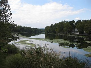
Conococheague Creek, a tributary of the Potomac River, is a free-flowing stream that originates in Pennsylvania and empties into the Potomac River near Williamsport, Maryland. It is 80 miles (129 km) in length, with 57 miles (92 km) in Pennsylvania and 23 miles (37 km) in Maryland. The watershed of Conococheague Creek has an area of approximately 566 square miles (1,470 km2), out of which only 65 square miles (170 km2) are in Maryland.
Conodoguinet Creek is a 104-mile-long (167 km) tributary of the Susquehanna River in South central Pennsylvania in the United States. The name is Native American, and means "A Long Way with Many Bends".
Spring Creek is a 25.2-mile-long (40.6 km) tributary of Bald Eagle Creek in Centre County, Pennsylvania in the United States.
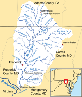
Marsh Creek is a 26.6-mile-long (42.8 km) tributary of the Monocacy River in south-central Pennsylvania and north-central Maryland in the United States.
Buck Run is an 8.8-mile-long (14.2 km) tributary of the West Branch Conococheague Creek in Franklin County, Pennsylvania. Buck Run rises along the eastern base of Tuscarora Mountain, just below Tuscarora Summit, and cuts through Buchanan's Birthplace State Park before meeting the West Branch Conococheague Creek north of Mercersburg.
Little Conococheague Creek is a 12.4-mile-long (20.0 km) tributary stream of the Potomac River in the U.S. states of Maryland and Pennsylvania. The stream rises on Two Top Mountain, west of the Whitetail Ski Resort in Franklin County, Pennsylvania, and proceeds south into Washington County, Maryland. It empties into the Potomac about 2 miles (3 km) southeast of Big Spring, Maryland. The watershed of the creek is 18 square miles (47 km2) and includes Indian Springs Wildlife Management Area. Tributaries include Toms Run.
Tuscarora Creek is a 49.2-mile-long (79.2 km) tributary of the Juniata River in central Pennsylvania in the United States. It rises in eastern Huntingdon County, east of the borough of Shade Gap, and flows northeast between Tuscarora Mountain and Shade Mountain, reaching the Juniata River at Port Royal in Juniata County.

Evitts Creek is a tributary stream of the North Branch Potomac River in the U.S. states of Pennsylvania and Maryland. The confluence of Evitts Creek and the North Branch Potomac River is located 2 miles (3 km) east of Cumberland, Maryland.
Honey Creek is a 20.3-mile-long (32.7 km) tributary of Kishacoquillas Creek in Mifflin County, Pennsylvania in the United States.

Mountain Creek is a 20.9-mile-long (33.6 km) tributary of Yellow Breeches Creek in Cumberland County, Pennsylvania.
References
- ↑ U.S. Geological Survey. National Hydrography Dataset high-resolution flowline data. The National Map Archived 2012-03-29 at the Wayback Machine , accessed August 15, 2011
- 1 2 3 Gertler, Edward. Keystone Canoeing, Seneca Press, 2004. ISBN 0-9749692-0-6
Coordinates: 39°50′55″N77°48′02″W / 39.8486°N 77.8005°W
| | This Franklin County, Pennsylvania state location article is a stub. You can help Wikipedia by expanding it. |