The geology of the Lassen volcanic area presents a record of sedimentation and volcanic activity in the area in and around Lassen Volcanic National Park in Northern California, U.S. The park is located in the southernmost part of the Cascade Mountain Range in the Pacific Northwest region of the United States. Pacific Oceanic tectonic plates have plunged below the North American Plate in this part of North America for hundreds of millions of years. Heat from these subducting plates has fed scores of volcanoes in California, Oregon, Washington and British Columbia over at least the past 30 million years and is also responsible for activities in the Lassen volcanic area.
Medicine Lake Volcano is a large shield volcano in northeastern California about 30 miles (50 km) northeast of Mount Shasta. The volcano is located in a zone of east-west crustal extension east of the main axis of the Cascade Volcanic Arc and the Cascade Range. The 0.6-mile (1 km) thick shield is 22 miles (35 km) from east to west and 28 to 31 miles from north to south, and covers more than 770 square miles (2,000 km2). The underlying rock has downwarped by 0.3 miles (0.5 km) under the center of the volcano. The volcano is primarily composed of basalt and basaltic andesite lava flows, and has a 4.3-by-7.5-mile caldera at the center.

The Garibaldi Volcanic Belt is a northwest-southeast trending volcanic chain in the Pacific Ranges of the Coast Mountains that extends from Watts Point in the south to the Ha-Iltzuk Icefield in the north. This chain of volcanoes is located in southwestern British Columbia, Canada. It forms the northernmost segment of the Cascade Volcanic Arc, which includes Mount St. Helens and Mount Baker. Most volcanoes of the Garibaldi chain are dormant stratovolcanoes and subglacial volcanoes that have been eroded by glacial ice. Less common volcanic landforms include cinder cones, volcanic plugs, lava domes and calderas. These diverse formations were created by different styles of volcanic activity, including Peléan and Plinian eruptions.

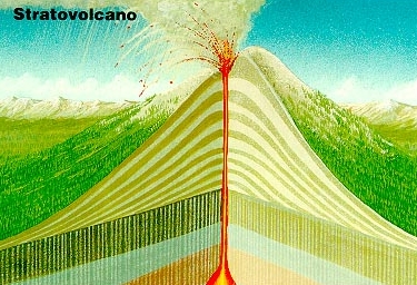
In volcanology, a lava dome or volcanic dome is a roughly circular mound-shaped protrusion resulting from the slow extrusion of viscous lava from a volcano. Dome-building eruptions are common, particularly in convergent plate boundary settings. Around 6% of eruptions on earth are lava dome forming. The geochemistry of lava domes can vary from basalt to rhyolite although the majority are of intermediate composition The characteristic dome shape is attributed to high viscosity that prevents the lava from flowing very far. This high viscosity can be obtained in two ways: by high levels of silica in the magma, or by degassing of fluid magma. Since viscous basaltic and andesitic domes weather fast and easily break apart by further input of fluid lava, most of the preserved domes have high silica content and consist of rhyolite or dacite.

Bazman is a stratovolcano in a remote desert region of Sistan and Baluchestan Province in south-eastern Iran. A 500-m-wide crater caps the summit of the dominantly andesitic-dacitic volcano, the flanks of which are covered by monogenetic centres especially to the northwest. Bazman is a geologically young volcano which was made in the Quaternary, with the oldest dated rocks being 11.7 million years old and the youngest 0.6 million years. Although no historic eruptions have been reported from Bazman, it does contain fumaroles. Thus Bazman may be regarded as dormant, rather than extinct. Its satellite cones have been the source of basaltic lava flows.

The Slave Craton is an Archaean craton in the north-western Canadian Shield, in Northwest Territories and Nunavut. The Slave Craton includes the 4.03 Ga-old Acasta Gneiss which is one of the oldest dated rocks on Earth. Covering about 300,000 km2 (120,000 sq mi), it is a relatively small but well-exposed craton dominated by ~2.73–2.63 Ga greenstones and turbidite sequences and ~2.72–2.58 Ga plutonic rocks, with large parts of the craton underlain by older gneiss and granitoid units. The Slave Craton is one of the blocks that compose the Precambrian core of North America, also known as the palaeocontinent Laurentia.
Mathews Tuya is a tuya in northcentral British Columbia. It is one of the six tuyas close to Tuya Lake. It has been partly glaciated and Ar-Ar geochronology shows that is it about 730,000 years old. It mainly comprises palagonitized tephra but also has a few dykes and jointed lava flows on its flanks. The top still has flat-lying lava flows erupted after the tephra pile grew above the surface of the enclosing lake. The other volcanoes in the area include Tuya Butte, South Tuya and Ash Mountain. The volcanoes in the region form part of the Northern Cordilleran Volcanic Province.

Ollagüe or Ullawi is a massive andesite stratovolcano in the Andes on the border between Bolivia and Chile, within the Antofagasta Region of Chile and the Potosi Department of Bolivia. Part of the Central Volcanic Zone of the Andes, its highest summit is 5,868 metres (19,252 ft) above sea level and features a summit crater that opens to the south. The western rim of the summit crater is formed by a compound of lava domes, the youngest of which features a vigorous fumarole that is visible from afar.

Level Mountain is a massive complex volcano in the Northern Interior of British Columbia, Canada. It is located 50 km (31 mi) north-northwest of Telegraph Creek and 60 km (37 mi) west of Dease Lake on the Nahlin Plateau. With a maximum elevation of 2,166 m (7,106 ft), it is the third highest of five large complexes in an extensive north-south trending volcanic zone. Much of the mountain is gently-sloping; when measured from its base, Level Mountain is about 1,100 m (3,600 ft) tall, slightly taller than its neighbour to the northwest, Heart Peaks. The lower broader half of Level Mountain consists of a shield-like edifice while its upper half has a more steep, jagged profile. Its large summit is dominated by the Level Mountain Range, a small mountain range with prominent peaks cut by deep valleys. These valleys serve as a radial drainage for several small streams that flow from the volcano. Meszah Peak is the only named peak in the Level Mountain Range.

The Mount Pleasant Caldera is a large eroded Late Devonian volcanic caldera complex, located in the northern Appalachian Mountains of southwestern New Brunswick, Canada. It is one of few noticeable pre-Cenozoic calderas, and its formation is associated to a period of crustal thinning that followed the Acadian orogeny in the northern Appalachian Mountains. It sits relatively near to the coastline.

Volcán Linzor is a stratovolcano on the border between Bolivia and Chile. In its vicinity lie Laguna Colorada and Cerro del León.

Mount Nansen is a deeply eroded Mid-Cretaceous stratovolcano located 53 km (33 mi) west of Carmacks and 10 km (6.2 mi) west of Victoria Mountain in the central Yukon, Canada. It consists of rhyolite, dacite, andesite flows, breccias and tuff. Mount Nansen was formed during subducting under North America during the Mid-Cretaceous.

The Silverthrone Caldera is a potentially active caldera complex in southwestern British Columbia, Canada, located over 350 kilometres (220 mi) northwest of the city of Vancouver and about 50 kilometres (31 mi) west of Mount Waddington in the Pacific Ranges of the Coast Mountains. The caldera is one of the largest of the few calderas in western Canada, measuring about 30 kilometres (19 mi) long (north-south) and 20 kilometres (12 mi) wide (east-west). Mount Silverthrone, an eroded lava dome on the caldera's northern flank that is 2,864 metres (9,396 ft) high may be the highest volcano in Canada.

Mount Labo, is a potentially active stratovolcano in the province of Camarines Norte, in Region V, on Luzon Island, in the Philippines. It is located at the northwest end of the Bicol Peninsula.

Ceboruco is a dacitic stratovolcano located in Nayarit, Mexico, northwest of the Trans-Mexican Volcanic Belt. The largest eruption, the Jala Plinian eruption, was around 930 AD ±200, VEI 6, releasing 11 cubic kilometres (2.6 cu mi) of tephra. The most recent and best documented eruption from Ceboruco lasted from 1870–1875, with fumarole activity lasting well into the 20th century. The mountain features one large caldera, created during the Jala eruption, with a smaller crater nested inside that formed when the Dos Equis lava dome collapsed during the Coapales eruption around 1100 AD. Within both of these craters, are several explosive volcanic features, including scoria deposits, lava domes, and pyroclastic domes, or cinder cone volcanoes.

The Canadian Cascade Arc, also called the Canadian Cascades, is the Canadian segment of the North American Cascade Volcanic Arc. Located entirely within the Canadian province of British Columbia, it extends from the Cascade Mountains in the south to the Coast Mountains in the north. Specifically, the southern end of the Canadian Cascades begin at the Canada–United States border. However, the specific boundaries of the northern end are not precisely known and the geology in this part of the volcanic arc is poorly understood. It is widely accepted by geologists that the Canadian Cascade Arc extends through the Pacific Ranges of the Coast Mountains. However, others have expressed concern that the volcanic arc possibly extends further north into the Kitimat Ranges, another subdivision of the Coast Mountains, and even as far north as Haida Gwaii.

The Wrekin Terrane is one of five inferred fault bounded terranes that make up the basement rocks of the southern United Kingdom. The other notable geological terranes are the Charnwood Terrane, Fenland Terrane, Cymru Terrane and the Monian Composite Terrane. The Wrekin Terrane is bounded to the west by the Welsh Borderland Fault System and to the east by the Malvern Lineament. The geological terrane to the west is the Cymru Terrane and to the east is Charnwood Terrane. The majority of rocks in the area are associated with the outcrops that are evident at the faulted boundaries.

The Keli (Qeli) Highland is a volcanic field in Georgia on the western side of the Jvari Pass south to the Greater Caucasus range. More than thirty volcanic edifices on an area of 20x30km2 make up this volcanic field, which consists mostly of monogenetic volcanic structures. The lavas are rhyolites, trachyandesites and andesites.
Nevados de Pastos Grandes is a Miocene volcanic centre in the Puna, Salta province, Argentina. It is a volcanic complex with several centres named El Queva, Gordo and Azufre. Some minor Pleistocene glaciation has affected the volcanic complex.

Archean felsic volcanic rocks are felsic volcanic rocks that were formed in the Archean Eon. The term "felsic" means that the rocks have silica content of 62–78%. Given that the Earth formed at ~4.5 billion year ago, Archean felsic volcanic rocks provide clues on the Earth's first volcanic activities on the Earth's surface started 500 million years after the Earth's formation.