Bada (rural locality)

Last updated

Coordinates: 51°24′N109°54′E / 51.400°N 109.900°E / 51.400; 109.900

Geographic coordinate system Coordinate system

A geographic coordinate system is a coordinate system that enables every location on Earth to be specified by a set of numbers, letters or symbols. The coordinates are often chosen such that one of the numbers represents a vertical position and two or three of the numbers represent a horizontal position; alternatively, a geographic position may be expressed in a combined three-dimensional Cartesian vector. A common choice of coordinates is latitude, longitude and elevation. To specify a location on a plane requires a map projection.

Bada (Russian : Бада) is a rural locality (a selo ) in Khiloksky District of Zabaykalsky Krai, Russia, located along the Khilok River. Population: 4,687(2010 Census); [1] 5,382(2002 Census). [2]

Russian language East Slavic language

Russian is an East Slavic language, which is official in the Russian Federation, Belarus, Kazakhstan and Kyrgyzstan, as well as being widely used throughout Eastern Europe, the Baltic states, the Caucasus and Central Asia. It was the de facto language of the Soviet Union until its dissolution on 25 December 1991. Although, nowadays, nearly three decades after the breakup of the Soviet Union, Russian is used in official capacity or in public life in all the post-Soviet nation-states, as well as in Israel and Mongolia, the rise of state-specific varieties of this language tends to be strongly denied in Russia, in line with the Russian World ideology.

The classification system of the types of inhabited localities in Russia, the former Soviet Union, and some other post-Soviet states has certain peculiarities compared with the classification systems in other countries.

Khiloksky District District in Zabaykalsky Krai, Russia

Khiloksky District is an administrative and municipal district (raion), one of the thirty-one in Zabaykalsky Krai, Russia. It is located in the southwest of the krai, and borders with Ulyotovsky District in the east, Krasnochikoysky District in the south, and with Petrovsk-Zabaykalsky District in the west. The area of the district is 14,800 square kilometers (5,700 sq mi). Its administrative center is the town of Khilok. Population: 31,760 (2010 Census); 33,434 ; 40,758 (1989 Census). The population of Khilok accounts for 36.3% of the district's total population.

History

The first train at the future Bada station The first train at Bada station (Khiloksky District, Zabaykalsky Krai, Russia - 1895).jpg
The first train at the future Bada station

Bada was founded in 1895 as a railway station of the Trans-Siberian Railway. During the Russian Civil War in Transbaikal in 1920, the Japanese Expeditionary Troops and military formations of the Far Eastern Republic met at the Bada and Gongota stations to ensure a secure evacuation of the Japanese forces home. Prompted by the Japanese withdrawal from Eastern Siberia during summer of 1920, the Soviet troops launched a series of operations which ended in liberation of Chita and Transbaikal from the troops of ataman Grigory Semyonov in October 1920.

Trans-Siberian Railway network of railways connecting Moscow with the Russian Far East and the Sea of Japan

The Trans-Siberian Railway is a network of railways connecting Moscow with the Russian Far East. With a length of 9,289 kilometres, from Moscow to Vladivostok, it is the longest railway line in the world. There are connecting branch lines into Mongolia, China and North Korea. It has connected Moscow with Vladivostok since 1916, and is still being expanded.

Russian Civil War multi-party war in the former Russian Empire, November 1917-October 1922

The Russian Civil War was a multi-party war in the former Russian Empire immediately after the two Russian Revolutions of 1917, as many factions vied to determine Russia's political future. The two largest combatant groups were the Red Army, fighting for the Bolshevik form of socialism led by Vladimir Lenin, and the loosely allied forces known as the White Army, which included diverse interests favoring political monarchism, economic capitalism and alternative forms of socialism, each with democratic and antidemocratic variants. In addition, rival militant socialists and nonideological Green armies fought against both the Bolsheviks and the Whites. Eight foreign nations intervened against the Red Army, notably the former Allied military forces from the World War and the pro-German armies. The Red Army eventually defeated the White Armed Forces of South Russia in Ukraine and the army led by Admiral Aleksandr Kolchak to the east in Siberia in 1919. The remains of the White forces commanded by Pyotr Nikolayevich Wrangel were beaten in Crimea and evacuated in late 1920. Lesser battles of the war continued on the periphery for two more years, and minor skirmishes with the remnants of the White forces in the Far East continued well into 1923. The war ended in 1923 in the sense that Bolshevik communist control of the newly formed Soviet Union was now assured, although armed national resistance in Central Asia was not completely crushed until 1934. There were an estimated 7,000,000–12,000,000 casualties during the war, mostly civilians. The Russian Civil War has been described by some as the greatest national catastrophe that Europe had yet seen.

Transbaikal region in Russia

Transbaikal, Trans-Baikal, Transbaikalia, or Dauria is a mountainous region to the east of or "beyond" (trans-) Lake Baikal in Russia.

In the following decades Bada developed quickly and its population increased significantly in the 1960s because of the nearby construction of Bada air base.

Bada (air base)

Bada is an air base in Russia located 3 km north-east of Bada in Zabaykalsky Krai. There are several clusters of remote revetments for fighter aircraft, and large tarmac. Forward aviation base.

Since the 1990s, there has been a permanent population decrease in Bada and nearby villages. The railroad is currently the only provider of employment.

Related Research Articles

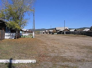
Drakino is a rural locality in Liskinsky District of Voronezh Oblast, Russia.

Izmaylovskoye Municipal Okrug human settlement in Russia

Izmaylovskoye Municipal Okrug is a municipal okrug of Admiralteysky District of the federal city of St. Petersburg, Russia. Population: 26,355 (2010 Census); 30,415 (2002 Census).

Liteyny Municipal Okrug human settlement in Russia

Liteyny Municipal Okrug is a municipal okrug of Tsentralny District of the federal city of St. Petersburg, Russia. Population: 44,864 (2010 Census); 50,567 (2002 Census).

Vvedensky Municipal Okrug human settlement in Russia

Vvedensky Municipal Okrug, formerly Municipal Okrug #58, is a municipal okrug of Petrogradsky District of the federal city of St. Petersburg, Russia. Population: 19,778 (2010 Census); 21,374 (2002 Census).

Serovo

Serovo is a municipal settlement in Kurortny District of the federal city of St. Petersburg, Russia, located on the Karelian Isthmus, on the northern shore of the Gulf of Finland, where the Roshchinka River empties into the gulf. Population: 280 (2010 Census); 252 (2002 Census).

Levashovo, Saint Petersburg

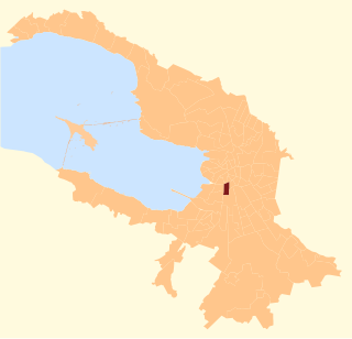
Levashovo is a municipal settlement under the administrative jurisdiction of Vyborgsky District of the federal city of St. Petersburg, Russia, and a station of the Riihimäki – Saint Petersburg Railway. Population: 3,665 (2010 Census); 4,095 (2002 Census).

Tungiro-Olyokminsky District District in Zabaykalsky Krai, Russia

Tungiro-Olyokminsky District is an administrative and municipal district (raion), one of the thirty-one in Zabaykalsky Krai, Russia. It is located in the northeast of the krai, and borders with Kalarsky District in the north, Mogochinsky District in the south, and with Tungokochensky District in the west. The area of the district is 42,900 square kilometers (16,600 sq mi). Its administrative center is the rural locality of Tupik. Population: 1,432 (2010 Census); 1,643 ; 1,899 (1989 Census). The population of Tupik accounts for 67.8% of the district's total population.

Khomutovka, Kursk Oblast human settlement in Russia

Khomutovka is an urban locality and the administrative center of Khomutovsky District of Kursk Oblast, Russia. Population: 4,230 (2010 Census); 5,050 (2002 Census); 5,578 (1989 Census). Telephone code: +7 47137; postal code: 307540.

Baleysky District is an administrative and municipal district (raion), one of the thirty-one in Zabaykalsky Krai, Russia. It is located in the southern central part of the krai, and borders Nerchinsky District in the north, Shelopuginsky District in the east, Borzinsky District in the south, and with Olovyanninsky District in the west. The area of the district is 5,000 square kilometers (1,900 sq mi). Its administrative center is the town of Baley. As of the 2010 Census, the total population of the district was 20,500, with the population of Baley accounting for 61.1% of that number.

Kalgansky District is an administrative and municipal district (raion), one of the thirty-one in Zabaykalsky Krai, Russia. It is located in the southeast of the krai and borders Nerchinsko-Zavodsky District in the north, Priargunsky District in the south, and Alexandrovo-Zavodsky District in the west. The area of the district is 2,900 square kilometers (1,100 sq mi). Its administrative center is the rural locality of Kalga. As of the 2010 Census, the total population of the district was 8,771, with the population of Kalga accounting for 39.1% of that number.

Shelopuginsky District is an administrative and municipal district (raion), one of the thirty-one in Zabaykalsky Krai, Russia. It is located in the center of the krai, and borders with Sretensky District in the north, Gazimuro-Zavodsky District in the east, Aleksandrovo-Zavodsky District in the south, and with Akshinsky District in the west. The area of the district is 3,900 square kilometers (1,500 sq mi). Its administrative center is the rural locality of Shelopugino. Population: 8,369 (2010 Census); 9,773 ; 13,124 (1989 Census). The population of Shelopugino accounts for 39.1% of the district's total population.

Tarbagatay is a rural locality in Tarbagataysky District of the Republic of Buryatia, Russia. Population: 4,308 (2010 Census); 4,246 (2002 Census);

Tarbagatay is a rural locality in Zaigrayevsky District of the Republic of Buryatia, Russia. Population: 30 (2010 Census); 52 (2002 Census);

Tarbagatay is a rural locality in Khorinsky District of the Republic of Buryatia, Russia. Population: 157 (2010 Census); 211 (2002 Census);

Putyatin is an urban locality under the administrative jurisdiction of the closed town of Fokino in Primorsky Krai, Russia. Population: 887 (2010 Census); 1,133 (2002 Census);

Kalga Selo in Zabaykalsky Krai, Russia

Kalga is a rural locality and the administrative center of Kalgansky District of Zabaykalsky Krai, Russia.

Dauriya is a settlement in Zabaykalsky District of Zabaykalsky Krai in Russia, the administrative center of the Daursky Rural Settlement.

Selyatino Urban-type settlement in Moscow Oblast, Russia

Selyatino is an urban locality in Naro-Fominsky District of Moscow Oblast, Russia. Population: 12,629 (2010 Census); 13,062 (2002 Census);

Teploozyorsk is an urban locality in Obluchensky District of the Jewish Autonomous Oblast, Russia. Population: 4,311 (2010 Census); 5,124 (2002 Census); 5,775 (1989 Census).

Leninskoye is a rural locality (a and the administrative center of Leninsky District of the Jewish Autonomous Oblast, Russia. Population: 6,109  ; 7,048  ; 6,707  .

References

  1. Russian Federal State Statistics Service (2011). "Всероссийская перепись населения 2010 года. Том 1" [2010 All-Russian Population Census, vol. 1]. Всероссийская перепись населения 2010 года (2010 All-Russia Population Census) (in Russian). Federal State Statistics Service . Retrieved June 29, 2012.
  2. Russian Federal State Statistics Service (May 21, 2004). "Численность населения России, субъектов Российской Федерации в составе федеральных округов, районов, городских поселений, сельских населённых пунктов – районных центров и сельских населённых пунктов с населением 3 тысячи и более человек" [Population of Russia, Its Federal Districts, Federal Subjects, Districts, Urban Localities, Rural Localities—Administrative Centers, and Rural Localities with Population of Over 3,000](XLS). Всероссийская перепись населения 2002 года [All-Russia Population Census of 2002] (in Russian). Retrieved August 9, 2014.