
Hanumangarh is a city in the Indian state of Rajasthan, situated on the banks of the river Ghaggar also identified as Ancient Sarasvati river, located about 400 km from Delhi. It is the administrative seat of Hanumangarh District. The city was once called Bhatner because it was founded by king Bhupat in 255 AD. It remained in the control of the Rajputs of Bhati clan and faced a historic siege by Timur in 1391, during which the Bhati Raput king Dulachand lost the fort for a short time. The fort was later occupied by Rao Jetsa of Bikaner.
Sri Ganganagar is a planned city and the northernmost city of the Indian state of Rajasthan, near the international border of India and Pakistan. It is the administrative headquarters of Sri Ganganagar district. It is named after Maharaja Shri Ganga Singh Bahadur, Maharaja of Bikaner. The city is also known as the "food basket of Rajasthan".

Sri Ganganagar district is the northernmost district of Rajasthan state in western India.
Bhadra is a city and a municipality in Hanumangarh district in the state of Rajasthan, India.
Gajsinghpur is a town near the border area in Sri Ganganagar district in the Indian state of Rajasthan. Census of 2011 is 9995.
Rawatsar is a city, a municipality, and one of the seven tehsils in Hanumangarh district in the Indian state of Rajasthan. It is divided into 35 wards for which elections are held every five years.

Suratgarh is a city and a municipality, just nearby Sri Ganganagar city in Sri Ganganagar district in the Indian state of Rajasthan. Founded by Maharaja Surat Singh. Hindi, Bagri and Rajasthani are the widely spoken languages of the city.
Goluwala is a city in Hanumangarh district of Rajasthan, India. It belongs to Bikaner division. It is divided into two suburbs– Niwadan (24JRK) and Sihagan (22JRK). It is an industrial town located some 31 km west of Hanumangarh and around 51 km off to Sri Ganganagar. Total Population of Goluwala Niwadan(24JRK) & Sihagan(22JRK) is 14960 (9753+5207) in 2011 census. Goluwala can be reached from Pilibangan, the nearest railway station. It is 18 km off National Highway 62 (India) and 431 km from State capital Jaipur.It is popular as name "Goluwala the Golden City".

The Ottu barrage, sometimes spelled as the Otu barrage and also known as Ottu Head, is a masonry weir on the Ghaggar-Hakra River in Sirsa, Haryana state of India that creates a large water reservoir out of the formerly-small Dhanur lake, located near the village of Ottu, which is about 8 miles from Sirsa City in Haryana, India. It is a feeder for the two Ghaggar canals that carry irrigation water to northern Haryana state. In 2002, a new tourist complex was inaugurated at the barrage, and it was given the honorary name of "Chaudhary Devi Lal Weir" to commemorate the former Chief Minister of Haryana state, Chaudhary Devi Lal. The Dhanur lake reservoir is now often referred to simply as the Ottu reservoir.
Suratgarh tehsil is the largest administrative region (tehsil) in the Ganganagar district. It is bordered on the north by Padampur tehsil, on the west by Vijaynagar tehsil and Raisinghnagar tehsil, on the south by Bikaner district, and on the east by Hanumangarh district. Suratgarh is a Brand.
Sri Gurusar Modia is a village in the Indian state of Rajasthan situated near borders of Rajasthan, Haryana and Punjab states and the international border of India and Pakistan. This village is located in the tehsil Suratgarh of district Sriganganagar. Suratgarh, once known as Sodhal was believed to be surrounded by the confluence of Saraswati and Drishyati rivers but now the land is a deserted one lying amidst the expanse of The great Indian Thar desert. Suratgarh is famous for its agriculture, air force and army base stations, largest thermal power plant of Rajasthan and largest radio station of Rajasthan called as "Cotton City Channel". Sri Gurusar Modia came into limelight when a controversial self-proclaimed saint and spiritual leader Gurmeet Ram Rahim Singh was believed to be incarnated there and crowned to the throne of Dera Sacha Sauda at Sirsa in 1991. With setting up of Shah Satnam Schools for both boys and girls, super speciality hospitals etc. this village became nationwide popular
Rang Mahal is a village and an ancient Kushan era archaeological site on Suratgarh-Hanumangarh road in Suratgarh tehsil of Sri Ganganagar district in the Indian state of Rajasthan. It can be reached from Hanumangarh, Pilibangan, Suratgarh. Suratgarh is the nearest major railway station to Rang mahal village.

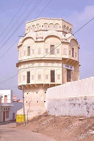
The Bhatner fort is at Hanumangarh in Rajasthan, India, about 419 km northwest of Jaipur along the old Multan-Delhi route and 230 km north-east of Bikaner. The old name of Hanumangarh was Bhatner, which means "fortress of the Bhati". Believed to be 1700 years old, it is considered to be one of the oldest forts of India.
Bangasar is a village in Rawatsar tehsil of Hanumangarh district in Rajasthan, India.
Pilibanga Assembly constituency is one of constituencies of Rajasthan Legislative Assembly in the Ganganagar.
Sambhar Lake Town railway station is in Jaipur district, Rajasthan. Its code is SBR. It serves Sambhar Lake Town and station consists of two platforms. Nearest junction is Phulera Junction
Khothanwali is a village in Hanumangarh district of Rajasthan, India. It belongs to Bikaner division. It is 48 km west of Hanumangarh. Suratgarh is the nearest railway station. It is 3 km from National Highway NH-62 (15)and 440 km from state capital Jaipur. In 2008 awarded the Nirmal Gram.
The 14719 / 14720 Bikaner–Bilaspur Antyodaya Express is an Express train belonging to North Western Railway zone that runs between Bikaner Junction and Bilaspur Junction.
Pilibanga railway station is a railway station in Hanumangarh district, Rajasthan. Its code is PGK. It serves Pilibanga town. The station consists of 2 platforms. Passenger, Express, and Superfast trains halt here.

