
East Pakistan was the eastern provincial wing of Pakistan between 1947 and 1971, covering the territory of the modern country Bangladesh. Its land borders were with India and Burma, with a coastline on the Bay of Bengal. East Pakistanis were popularly known as "Pakistani Bengalis"; to distinguish this region from India's state West Bengal, East Pakistan was known as "Pakistani Bengal".

Chittagong Division, officially known as Chattogram Division, is geographically the largest of the eight administrative divisions of Bangladesh. It covers the south-easternmost areas of the country, with a total area of 33,909.00 km2 (13,092.34 sq mi) and a population at the 2011 census of 28,423,019.^[6] The administrative division includes mainland Chittagong District, neighbouring districts and the Chittagong Hill Tracts.

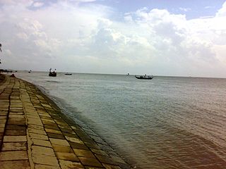
Cox's Bazar is a district in the Chittagong Division of Bangladesh. It is named after Cox's Bazar town. It is located 150 kilometres (93 mi) south of Chittagong. Cox's Bazar is also known by the name Panowa. Another old name was Palongkee. The modern Cox's Bazar derives its name from Captain Hiram Cox, an army officer who served in British India. It is one of the fishing ports of Bangladesh. At Cox's Bazar is one of the world's longest natural sea beaches.

Comilla District, officially known as Cumilla District, is a district of Bangladesh located about 100 kilometres south east of Dhaka. Comilla is bordered by Brahmanbaria and Narayanganj districts to the north, Noakhali and Feni districts to the south, Tripura of India to the east and Munshiganj and Chandpur districts to the west. Comilla district is located in the southeastern part of Bangladesh.
Lakshmipur (Bengali: লক্ষ্মীপুর, romanized: Lokkhipur, also spelt Laxmipur, with an area of 1455.96 km2, is a district of Bangladesh. It is bordered by Chandpur to the north, Bhola and Noakhali districts to the south, Noakhali to the east, and Barisal and Bhola districts to the west.

Shariatpur is a district in the Dhaka Division of central Bangladesh. It is bounded by Munshiganj district on the north, Barisal district on the south, Chandpur district on the east, Madaripur district on the west. Water bodies Main rivers: Padma, Meghna, Palong (Kirtinasha) and Jayanti. Of the six upazilas of the district Bhedarganj Upazila is the largest and Damudya Upazila is the smallest.
Dhaka District is a district in central Bangladesh, and is the densest district in the nation. It is a part of the Dhaka Division. Dhaka, the capital of Bangladesh, and rests on the eastern banks of the Buriganga River which flows from the Turag to the southern part of the district. While Dhaka occupies only about a fifth of the area of Dhaka district, it is the economic, political and cultural centre of the district and the country as a whole. Dhaka District consists with Dhaka, Keraniganj, Nababganj, Dohar, Savar and Dhamrai upazila. Dhaka District is an administrative entity, and like many other cities it does not cover the modern conurbation which is Greater Dhaka, which has spilled into neighbouring districts, nor does the conurbation cover the whole district, as there are rural areas within the district.
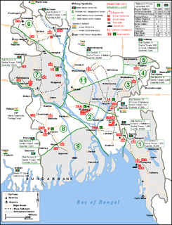
The Operation Jackpot was a codename for three operations undertaken by Bengali Mukti Bahini in former East Pakistan against the Federation of Pakistan during the climax of the Bangladesh Liberation War.

Haziganj or Hajiganj is an upazila of Chandpur District in the Division of Chittagong, Bangladesh.
Kachua is an upazila (sub-district) of Chandpur District in Bangladesh, located in the Chittagong Division. It is a part of the Greater Comilla region.
Laksam is an upazila of Comilla District in the Division of Chittagong, Bangladesh. Laksam is widely known as the birthplace of Nawab Faizunnesa Chowdhurani.

Moheshkhali is an upazila of Cox's Bazar District in the Division of Chittagong, Bangladesh.
Senbag is an upazila of Noakhali District. Senbag is located within an area of 155.83 square kilometres (60.2 sq mi), which is enclosed by Nangalkot upazila, Noakhali Sadar and Companiganj upazilas (south), Daganbhuyiyan upazila, Feni (east), with Begumganj and Laksam upazilas.

Kulaura is the biggest upazila (subdistrict) of the Moulvibazar District in north-eastern Bangladesh. The total area of this upazila is 545 km2. Hakaluki Haor, the largest marsh wetland in Sylhet and one of the largest in Bangladesh is partially located there.
Rajnagar is an upazila of the Moulvibazar District in the Division of Sylhet, Bangladesh. The district has roughly 29,300 houses and an area of approximately 340 km2. There are three well-known rivers which flow across the Upazila border side of Rajnagar: the Kushiara in the North, the Manu across the southern three unions, and the Dholai across Kamarchak and the southern border.
Ghior is an upazila (sub-district) of Manikganj District of central Bangladesh, located in the Dhaka Division. It is located at 23.8875°N 89.8375°E and is named after the town of Ghior. It is home to the Tarra Bridge, an overpass above the Dhaleshwari River, which is one of the major bridges of the country. The 53 km R506 road is one of the main roads of Ghior connecting the upazila to Dhaka and Tangail. Md. Nazmul Islam, Upazila Nirbahi Officer is the present Executive Head of the Upazila.
Bhaluka is an upazila of the Mymensingh District in Bangladesh. Bhaluka is one of the oldest small business hubs in the area.

Karwan Bazar is a business district and is one of the biggest commodity marketplaces in Dhaka city, the capital of Bangladesh. It is a designated commercial area of the Dhaka North City Corporation.
Suleman Khan was a Bangladesh physician who was killed in the Bangladesh Liberation war and is considered a martyr in Bangladesh.
Jute Industry in Bangladesh is an industry that is historically and culturally important that once was the biggest industry in the region but has declined since then. Jute was historically a major export item of Bangladesh but has declined since the 1970s. Exports have fallen as other countries grew jute and alternate products like plastic and hemp found more widespread use. Bangladesh produces, as of 2018, 33 percent of the total worldwide production of jute.
