Sierra Leone, officially the Republic of Sierra Leone, informally Salone, is a country on the southwest coast of West Africa. It is bordered by Liberia to the southeast and Guinea to the northeast. Sierra Leone has a tropical climate with a diverse environment ranging from savanna to rainforests, a total area of 71,740 km2 (27,699 sq mi) and a population of 7,092,113 as of the 2015 census. The capital and largest city is Freetown. The country is divided into five administrative regions which are subdivided into sixteen districts. Sierra Leone is a constitutional republic with a unicameral parliament and a directly elected president. Sierra Leone is a Muslim-majority country at approximately 78%, though with an influential Christian minority at about 21%. Muslims and Christians in Sierra Leone are extremely tolerant of each other, and all the major Muslim and Christian holidays are officially national holidays in the country.

Freetown is the capital and largest city of Sierra Leone. It is a major port city on the Atlantic Ocean and is located in the Western Area of the country. Freetown is Sierra Leone's major urban, economic, financial, cultural, educational and political centre, as it is the seat of the Government of Sierra Leone. The population of Freetown was 1,055,964 at the 2015 census.

Bo, also commonly referred to as Bo Town, is the second largest city in Sierra Leone by landscape/geographical location and the largest city in the Southern Province. Bo is the capital and administrative centre of Bo District. The city of Bo had a population of 149,957 in the 2004 census and had a population of about 233,684 based on 2017 estimate. Bo is an urban centre, and lies approximately 160 miles (250 km) eastsoutheast of Freetown, and about 40 miles (71 km) to Kenema. Bo is the leading financial, educational and economic centre of southern Sierra Leone.
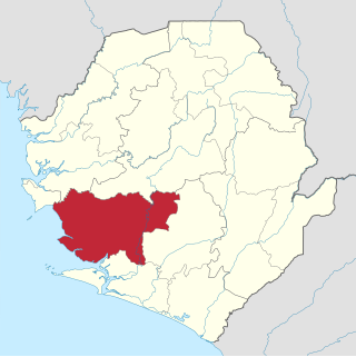
Moyamba District is a district in the Southern Province of Sierra Leone, with a population of 318,064 in the 2015 census. Its capital and largest city is Moyamba. The other major towns include Njala, Rotifunk and Shenge. The district is the largest in the Southern Province by geographical area, occupying a total area of 6,902 km2 (2,665 sq mi) and comprises fourteen chiefdoms.

The Western Area or Freetown Peninsula is one of five principal divisions of Sierra Leone. It comprises the oldest city and national capital Freetown and its surrounding towns and countryside. It covers an area of 557 km2 and has a population of 1,447,271. The Western Area is located mostly around the peninsula and is divided into two districts: the Western Area Rural and the Western Area Urban.

Bonthe is a coastal town located on Sherbro Island in Bonthe District in the southern Province of Sierra Leone. The town lies on the eastern shore of Sherbro Island, on the Sherbro River estuary. Bonthe is about 60 miles south-west of Bo and 187 miles south-east of Freetown.
The Limba people are the third largest ethnic group in Sierra Leone. They represent 8.4% of Sierra Leone's total population. They are based in the north of the country across seven provinces, comprising about 8% of the national populations.
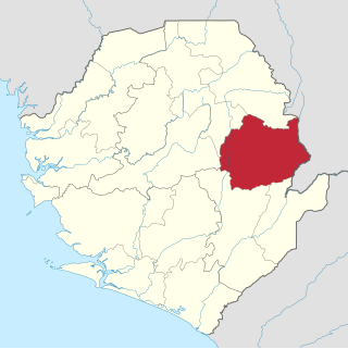
Kono District is a district in the Eastern Province of Sierra Leone. Its capital and largest city is Koidu Town. Motema is the second most populous city in the district. The other major towns in the district include Yengema, Tombodu, Jaiama Nimikor and Sewafe. The district is the largest diamond producer in Sierra Leone. The population of Kono District is 505,767. Kono District borders Kenema District to the southwest, The Republic of Guinea to the east, Koinadugu District to the northeast and Kailahun District to the southeast. Kono District is divided into fourteen chiefdoms.

Kailahun District is a district in the Eastern Province of Sierra Leone. Its capital and largest city is the town of Kailahun. The second most populous city in the district is Segbwema. Other major towns in Kailahun District unclude Koindu, Pendembu and Daru. As of the 2015 census, the district had a population of 525,372. Kailahun District is subdivided into fourteen chiefdoms.

The Western Area Rural District is one of the sixteen districts of Sierra Leone. It is located mostly around the peninsula in the Western Area of Sierra Leone. The Western Area Rural District has a 2015 census population of 442,951. The district capital and largest city is Waterloo. Other major towns in the district include Newton, Benguema, Leicester, Tombo and Regent. Most of the towns and villages in the Western area rural District are close to the capital Freetown; and are part of the Freetown Metropolitan Area.
Articles related to Sierra Leone include:
The following outline is provided as an overview of and topical guide to Sierra Leone:
Mattru Jong commonly known as Mattru is the capital of Bonthe District in the Southern Province of Sierra Leone. Mattru Jung is located on the mainland of Bonthe District, along the Jong River, 52 miles southwest of Bo. The town is the seat of Mongerewa Jong Chiefdom, and is the home of Mongerewa Jong Paramount Chief Alie Badara Sheriff III. The town's current estimated population is about 20,000 people. In 2010 it was 8,199, and in the 2004 census the town had a population of 7,647.
Sanda Tenraren is a chiefdom of Bombali District in the Northern Province of Sierra Leone. The principal town lies at Mateboi.
Sella Limba is a chiefdom of Bombali District in the Northern Province of Sierra Leone. The principal town lies at Kamakwie.
Gbanti Kamaranka is a chiefdom of Bombali District in the Northern Province of Sierra Leone. The principal town lies at Kamaranka.
Gbendembu Ngowahun is a chiefdom of Bombali District in the Northern Province of Sierra Leone. The principal towns are Gbendembu and Kalangba.
Paki Massabong is a chiefdom of Bombali District in the Northern Province of Sierra Leone. The principal town lies at Mapaki.
Libeisaygahun is a chiefdom of Bombali District in the Northern Province of Sierra Leone. The principal town lies at Batkanu.
Water supply in Sierra Leone is characterized by limited access to safe drinking water. Despite efforts by the government and numerous non-governmental organizations, access has not much improved since the end of the Sierra Leone Civil War in 2002, stagnating at about 50% and even declining in rural areas. In the capital Freetown, taps often run dry. It is hoped that a new dam in Orugu, for which China committed financing in 2009, will alleviate water scarcity.