Bailén

Last updated • 2 min readFrom Wikipedia, The Free Encyclopedia
Bailén
Parroquiadelaencarnacionbailen.jpg
Parish church of the Incarnation.
Bandera de Bailen (Jaen).svg
Escudo de Bailen (Jaen).svg
Jaen-loc.svg
Red pog.svg
Bailén
Location in Spain
Spain Andalusia location map.svg
Red pog.svg
Bailén
Bailén (Andalusia)
Spain location map with provinces.svg
Red pog.svg
Bailén
Bailén (Spain)
Coordinates: 38°5′N3°46′W / 38.083°N 3.767°W / 38.083; -3.767
CountryFlag of Spain.svg  Spain
Autonomous community Flag of Andalucia.svg  Andalusia
Province Jaén
Comarca Sierra Morena
Government
  MayorDavid Padilla Molina
Area
  Total
117.6 km2 (45.4 sq mi)
Elevation
343 m (1,125 ft)
Population
 (2018) [1]
  Total
17,820
  Density150/km2 (390/sq mi)
Demonym Bailenenses
Time zone UTC+1 (CET)
  Summer (DST) UTC+2 (CEST)
Postal code
23710
Website Official website

Bailén (archaically known as Baylen in English) is a town in the province of Jaén, Spain.

Contents

History

Bailén is probably the ancient Baecula, where the Romans, under Scipio the Elder, signally defeated the Carthaginians in 209 and 206 B.C. In its neighbourhood, also, in 1212, was fought the great Battle of Las Navas de Tolosa, in which, according to the ancient chroniclers, the Castilians under Alphonso VIII, slew 200,000 Almohads, and themselves only lost 25 men. Although this estimate is absurd, the victory of the Christians was complete. [2]

There is a convent that dates from 729. The city of Bailén has a large industrial activity of ceramics, wine and hospitality, along with the cultivation of herbaceous crops and the development of an olive oil industry. The municipal area of Bailén borders the municipalities of Baños de la Encina and Guarromán to the north and west, Linares to the east, to the south with Jabalquinto and Espeluy, and with Villanueva de la Reina.

The parish church of Nuestra Señora de la Encarnación, which was built in the 15th century, in the Elizabethan Gothic style, is one of the greatest architectural exponents of the town, declared a Historical Monument. Also noteworthy are the hermitages of Nuestra Señora de la Soledad ( 15th century ), in Gothic style, the hermitages of Jesús and El Cristo, both in baroque style ( 18th century ), that of the Virgin of Zocueca, built between the 17th and 18th centuries. xviii and the parish of San José Obrero, along with its neighborhood, which celebrates its festivities in its honor on May 1.

In 1808, during the Peninsular War, it was the site of a series of clashes (the Battle of Bailén) at which General Castaños defeated General Pierre Dupont. [3] The capitulation, signed at Andújar by Dupont on the 23rd of July 1808, involved the surrender of 17,000 men to the Spaniards, and was the first severe blow suffered by the French in the Peninsular War. [2]

Climate

Bailén has a Mediterranean climate (Köppen climate classification: Csa) with very hot, dry summers and mild, moderately wet winters, while precipitation is moderate throughout the year. Due to its location at the eastern end of the Guadalquivir, summers tend to be very hot with particularly warm nights, while winters are colder compared to the western areas of the valley. Furthermore, precipitation is scarcer compared to western areas, as it is further away from Atlantic Ocean influences. [4] The lowest temperature ever recorded was −3.7 °C (25.3 °F) on February 10, 2012, while the highest ever recorded was 45.2 °C (113.4 °F) on July 13, 2017.

Climate data for Bailén (2010-2024), extremes (2010-present)
MonthJanFebMarAprMayJunJulAugSepOctNovDecYear
Record high °C (°F)25.4
(77.7)
27.0
(80.6)
31.0
(87.8)
36.2
(97.2)
40.2
(104.4)
42.9
(109.2)
45.2
(113.4)
45.1
(113.2)
42.9
(109.2)
36.6
(97.9)
27.0
(80.6)
23.2
(73.8)
45.2
(113.4)
Mean daily maximum °C (°F)14.4
(57.9)
16.3
(61.3)
19.5
(67.1)
23.6
(74.5)
28.1
(82.6)
32.5
(90.5)
37.0
(98.6)
36.9
(98.4)
31.0
(87.8)
25.2
(77.4)
17.7
(63.9)
15.6
(60.1)
24.8
(76.7)
Daily mean °C (°F)9.3
(48.7)
10.8
(51.4)
13.6
(56.5)
17.4
(63.3)
21.3
(70.3)
25.4
(77.7)
29.3
(84.7)
29.3
(84.7)
24.4
(75.9)
19.4
(66.9)
13.2
(55.8)
10.4
(50.7)
18.7
(65.6)
Mean daily minimum °C (°F)4.1
(39.4)
5.3
(41.5)
7.8
(46.0)
11.1
(52.0)
14.4
(57.9)
18.3
(64.9)
21.5
(70.7)
21.7
(71.1)
17.9
(64.2)
13.6
(56.5)
8.6
(47.5)
5.3
(41.5)
12.5
(54.4)
Record low °C (°F)−2.8
(27.0)
−3.7
(25.3)
−1.0
(30.2)
3.8
(38.8)
4.9
(40.8)
11.1
(52.0)
15.5
(59.9)
16.2
(61.2)
11.5
(52.7)
3.5
(38.3)
−1.1
(30.0)
−2.6
(27.3)
−3.7
(25.3)
Average precipitation mm (inches)44.7
(1.76)
58.8
(2.31)
82.1
(3.23)
46.3
(1.82)
26.1
(1.03)
9.4
(0.37)
1.1
(0.04)
3.7
(0.15)
18.1
(0.71)
47.0
(1.85)
68.0
(2.68)
53.5
(2.11)
458.8
(18.06)
Source: Agencia Estatal de Meteorologia (AEMET OpenData) [5]

Economy

The town has many quarries, resulting in a reputation for craft products.

Significant Births

Twin towns

See also

Notes

  1. Municipal Register of Spain 2018. National Statistics Institute.
  2. 1 2 Wikisource-logo.svg One or more of the preceding sentences incorporates text from a publication now in the public domain :  Chisholm, Hugh, ed. (1911). "Bailén". Encyclopædia Britannica . Vol. 3 (11th ed.). Cambridge University Press. p. 217.
  3. Chandler, p. 618
  4. "Valores climatologicos normales". AEMET. Retrieved 30 October 2024.
  5. "AEMET OpeenData". Agencia Estatal de Meteorologia. Archived from the original on 16 May 2024. Retrieved 12 May 2024.

Related Research Articles

<span class="mw-page-title-main">Mérida, Spain</span> Municipality in Extremadura, Spain

Mérida is a city and municipality of Spain, part of the Province of Badajoz, and capital of the autonomous community of Extremadura. Located in the western-central part of the Iberian Peninsula at 217 metres above sea level, the city is crossed by the Guadiana and Albarregas rivers. The population was 60,119 in 2017.

<span class="mw-page-title-main">Soria</span> Municipality in Castile and León, Spain

Soria is a municipality and a Spanish city, located on the Douro river in the east of the autonomous community of Castile and León and capital of the province of Soria. Its population is 38,881, 43.7% of the provincial population. The municipality has a surface area of 271,77 km2, with a density of 144.97 inhabitants/km2. Situated at about 1065 metres above sea level, Soria is the second highest provincial capital in Spain.

<span class="mw-page-title-main">Andújar</span> Municipality in Andalusia, Spain

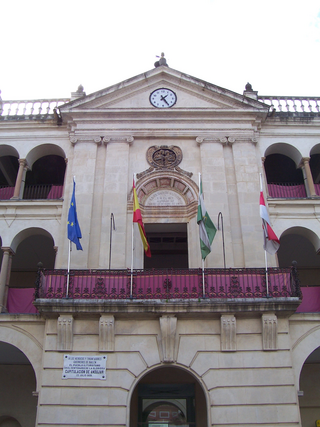
Andújar is a Spanish municipality of 38,539 people (2005) in the province of Jaén, in Andalusia. The municipality is divided by the Guadalquivir River. The northern part of the municipality is where the Natural Park of the Sierra de Andújar is situated. To the south are agricultural fields and countryside. The city proper located on the right bank of the Guadalquivir and the Madrid-Córdoba railway. In the past, Andújar was widely known for its porous earthenware jars, called alcarrazas or botijos, which keep water cool in the hottest weather, and were manufactured from a whitish clay found in the neighbourhood.

<span class="mw-page-title-main">Battle of Bailén</span> 1808 Battle in Peninsular War

The Battle of Bailén was fought in 1808 between the Spanish Army of Andalusia, led by General Francisco Javier Castaños and the Imperial French Army's II corps d'observation de la Gironde under General Pierre Dupont de l'Étang. This battle was the first open-field defeat of a Napoleonic army. The heaviest fighting took place near Bailén, a village by the Guadalquivir river in the Jaén province of southern Spain.

<span class="mw-page-title-main">Carcaixent</span> Municipality in Valencian Community, Spain

Carcaixent is a town and municipality in the province of Valencia, eastern Spain, with c. 20,000 inhabitants. Its origins go back to prehistoric Iberian and Roman times, with some remainders in its area. It is located in the Ribera Alta comarca, 40 km south of the provincial capital Valencia. It is the birthplace of the orange growth and its flourishing commerce in the 19th and 20th centuries. Currently, its inhabitants live basically on agriculture and the service sector.

<span class="mw-page-title-main">Francisco Javier Castaños, 1st Duke of Bailén</span> Spanish Army officer, politician and nobleman

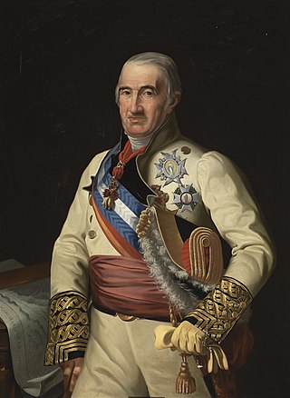
Francisco Javier Castaños Aragorri, 1st Duke of Bailén was a Spanish Army officer, politician and nobleman who served during the French Revolutionary and Napoleonic Wars. He presided over the Regency Council of Spain and the Indies, in 1810. From July to September 1834, Castaños served as the first president of the Senate of Spain, at that time called the House of Peers.

<span class="mw-page-title-main">Arcos de la Frontera</span> Municipality in Andalusia, Spain

Arcos de la Frontera is a town and municipality in the Sierra de Cádiz comarca, province of Cádiz, in Andalusia, Spain. It is located on the northern, western and southern banks of the Guadalete river, which flows around three sides of the city under towering vertical cliffs, to Jerez and on to the Bay of Cádiz. The town commands a fine vista atop a sandstone ridge, from which the peak of San Cristóbal and the Guadalete Valley can be seen. The town gained its name by being the frontier of Spain's 13th-century battle with the Moors.

<span class="mw-page-title-main">Chinchón</span> Municipality in Spain

Chinchón is a town and municipality in the Community of Madrid, Spain. Located 50 km south-east of the city of Madrid, the municipality covers an area of 115.91 km2. As of 2018, it has a population of 5,239. Its historic centre, with a notable main square, was declared a Heritage Site in 1974.

<span class="mw-page-title-main">Xàtiva</span> Municipality in Spain

Xàtiva is a town in eastern Spain, in the province of Valencia, on the right (western) bank of the river Albaida and at the junction of the Valencia–Murcia and Valencia Albacete railways. It is located 25 km west of the Mediterranean Sea. During the Al-Andalus Islamic era, Arabs brought the technology to manufacture paper to Xàtiva. In the 12th century, Xàtiva was known for its schools, education, and learning circles. Islamic scholar Abu Ishaq al-Shatibi's last name refers to Xàtiva where he lived and died. After the Reconquista by Northern Christian kingdoms and the following Christian repopulation, the city became the cradle of one of the most powerful and controversial families of the Renaissance, the House of Borgia, which produced Popes like Callixtus III and Alexander VI.

<span class="mw-page-title-main">Don Benito</span> Municipality in Extremadura, Spain

Don Benito is a Spanish town and municipality in the province of Badajoz, Extremadura, near the left bank of the river Guadiana. According to the 2014 census, the municipality has a population of 37,011.

<span class="mw-page-title-main">Puebla de Sanabria</span> Place in Castile and León, Spain

Puebla de Sanabria is a small town located in the north-western part of the province of Zamora in Spain, between the rivers Tera and Castro.

<span class="mw-page-title-main">Almagro, Ciudad Real</span> Municipality in Castile-La Mancha, Spain

Almagro is a town and municipality situated in Ciudad Real province, in the autonomous community of Castile-La Mancha, Spain. A tourist destination, Almagro is designated a Conjunto histórico, a type of conservation area.

<span class="mw-page-title-main">Aldeadávila de la Ribera</span> Municipality in Castile and León, Spain

Aldeadávila de la Ribera is a village and municipality in the north-west of the province of Salamanca, western Spain, part of the autonomous community of Castile and León.

<span class="mw-page-title-main">Sigüenza</span> Municipality in Castile-La Mancha, Spain

Sigüenza is a city in the Serranía de Guadalajara comarca, Province of Guadalajara, Castile-La Mancha, Spain.

<span class="mw-page-title-main">Calanda, Spain</span> Municipality in Aragon, Spain

Calanda is a town in the province of Teruel, Aragon, Spain. It lies on the southern fringe of the Ebro river basin, at the confluence of the Rivers Guadalope and Guadalopillo.

<span class="mw-page-title-main">Coria, Cáceres</span> Municipality in Extremadura, Spain

Coria is a municipality of Spain belonging to the province of Cáceres, Extremadura. In addition to the town of the same name, the municipality also comprises the settlements of Puebla de Argeme and Rincón del Obispo. With a population of has 12,531 inhabitants, Coria is the fourth most-populated municipality in the province.

<span class="mw-page-title-main">Zarza de Granadilla</span> Municipality in Extremadura, Spain

Zarza de Granadilla is a Spanish municipality in Cáceres Province, Extremadura. Zarza de Granadilla has a population of 1873.

<span class="mw-page-title-main">El Tiemblo</span> Municipality in Castile and León, Spain

El Tiemblo is a municipality located in the province of Ávila, Castile and León, Spain. According to the 2012 census (INE), the municipality has a population of 4,461 inhabitants, and covers an area of about 75 km2.

Urueña is a municipality located in the province of Valladolid, Castile and León, Spain. According to the 2004 census (INE), the municipality has a population of 213 inhabitants.

<span class="mw-page-title-main">Torrelaguna</span> Municipality in Community of Madrid, Spain

Torrelaguna is a municipality in the Community of Madrid, Spain. It covers an area of 43.40 km2. As of 2022, it has a population of 4,940.

References