Baker, Nebraska | |
|---|---|
 Baker, Nebraska | |
| Coordinates: 42°59′20″N98°43′51″W / 42.98889°N 98.73092°W | |
| Country | |
| State | |
| County | Boyd |
Baker is a ghost town in Boyd County, Nebraska, United States. [1]
Baker, Nebraska | |
|---|---|
| Baker, Nebraska | |
| Coordinates: 42°59′20″N98°43′51″W / 42.98889°N 98.73092°W | |
| Country | |
| State | |
| County | Boyd |
Baker is a ghost town in Boyd County, Nebraska, United States. [1]
A post office was established at Baker in 1891, and remained in operation until it was discontinued in 1906. [2] Baker was likely named for a pioneer settler. [3]
{{cite book}}: CS1 maint: ignored ISBN errors (link) A 1925 edition is available for download at University of Nebraska—Lincoln Digital Commons. Municipalities and communities of Boyd County, Nebraska, United States | ||
|---|---|---|
| Villages | 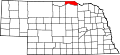 | |
| Townships | ||
| Ghost towns | ||
42°59′20″N98°43′51″W / 42.98889°N 98.73092°W
| | This Boyd County, Nebraska state location article is a stub. You can help Wikipedia by adding missing information. |