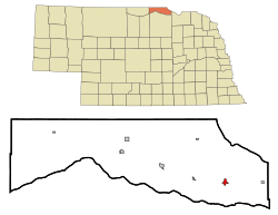
Lynch | |
---|---|
Village of Lynch | |
![]() A view of Lynch Nebraska | |
![]() Location within Boyd County | |
Coordinates: 42°49′52″N98°28′01″W / 42.83111°N 98.46694°W | |
Country | ![]() |
State | Nebraska |
County | Boyd |
Government | |
• Type | Mayor–council |
• Mayor | Jeff Hart |
Area | |
• Total | 0.53 sq mi (1.38 km2) |
• Land | 0.53 sq mi (1.38 km2) |
• Water | 0.00 sq mi (0.00 km2) |
Elevation | 1,411 ft (430 m) |
Population (2020) | |
• Total | 194 |
• Density | 363.30/sq mi (140.31/km2) |
Time zone | UTC-6 (Central (CST)) |
• Summer (DST) | UTC-5 (CDT) |
ZIP code | 68746 |
Area code | 402 |
FIPS code | 31-29750 [3] |
GNIS feature ID | 2399206 [2] |
Lynch is a village in Boyd County, Nebraska, United States. The population was 194 at the 2020 census, down from 245 in 2010. Lynch is located in northern Nebraska, between the Missouri and Niobrara rivers.
Lynch was incorporated as a village in 1892. [4] It was named for John Lynch, a pioneer settler. [4] [5]
Thirty of the one hundred homes in Lynch were destroyed by flooding in 2019. [6]
Lynch, Nebraska has a mayor-council government. It holds meetings at the Village Office on the second Monday of each month. There are four trustees, one chairperson, a clerk, and a treasurer.
The Lynch Volunteer Fire Department (LVFD), is made up of 20-25 volunteers. It provides fire protection for the town and surrounding areas as part of a mutual aid agreement. [7]
There is only one hired full-time Police Officer who is also a part-time Boyd County officer.
Junefest is held on the third weekend of June for adults and children. There are alumni banquet activities, a parade, a walk or run, and games at the city park. [8]
According to the United States Census Bureau, the village has a total area of 0.53 square miles (1.37 km2), all land. [9]
This climatic region is typified by large seasonal temperature differences, with warm to hot (and often humid) summers and cold (sometimes severely cold) winters. According to the Köppen Climate Classification system, Lynch has a humid continental climate, abbreviated "Dfa" on climate maps. [10]
Climate data for Lynch, Nebraska | |||||||||||||
---|---|---|---|---|---|---|---|---|---|---|---|---|---|
Month | Jan | Feb | Mar | Apr | May | Jun | Jul | Aug | Sep | Oct | Nov | Dec | Year |
Mean daily maximum °C (°F) | 1 (34) | 2 (36) | 9 (49) | 17 (62) | 23 (73) | 28 (82) | 31 (88) | 31 (87) | 26 (78) | 19 (66) | 9 (49) | 2 (36) | 16 (61) |
Mean daily minimum °C (°F) | −13 (8) | −12 (10) | −6 (22) | 1 (33) | 7 (45) | 13 (55) | 16 (61) | 15 (59) | 9 (48) | 2 (35) | −6 (22) | −12 (11) | 1 (34) |
Average precipitation mm (inches) | 13 (0.5) | 20 (0.8) | 38 (1.5) | 69 (2.7) | 86 (3.4) | 94 (3.7) | 76 (3) | 71 (2.8) | 58 (2.3) | 43 (1.7) | 20 (0.8) | 15 (0.6) | 600 (23.7) |
Source: Weatherbase [11] |
Census | Pop. | Note | %± |
---|---|---|---|
1900 | 231 | — | |
1910 | 583 | 152.4% | |
1920 | 589 | 1.0% | |
1930 | 498 | −15.4% | |
1940 | 487 | −2.2% | |
1950 | 440 | −9.7% | |
1960 | 409 | −7.0% | |
1970 | 375 | −8.3% | |
1980 | 357 | −4.8% | |
1990 | 296 | −17.1% | |
2000 | 269 | −9.1% | |
2010 | 245 | −8.9% | |
2020 | 194 | −20.8% | |
U.S. Decennial Census [12] |
As of the 2020 census, [13] there was a population of 194 and 144 households. The population density was 462.3 inhabitants per square mile (178.5/km2). There were 190 housing units at an average density of 337.7 units per square mile (130.4 units/km2). The racial makeup of the village was 99% White. Only two of all the residents are of any race.
22% of the village has a bachelor's degree education or higher, and the village has a 57% employment rate. 13% of the residents in the village do not have health care coverage. The Median Household income is $38,250. [14]
As of the 2000 census, [3] there were 269 people, 131 households, and 78 families residing in the village. The population density was 476.2 inhabitants per square mile (183.9/km2). There were 177 housing units at an average density of 313.3 units per square mile (121.0 units/km2). The racial makeup of the village was 96.28% White, 1.86% Native American, 0.37% Asian, and 1.49% from two or more races.
There were 131 households, out of which 18.3% had children under the age of 18 living with them, 52.7% were married couples living together, 3.8% had a female householder with no husband present, and 39.7% were non-families. 38.2% of all households were made up of individuals, and 22.1% had someone living alone who was 65 years of age or older. The average household size was 2.05 and the average family size was 2.63.
In the village, the population was spread out, with 21.2% under the age of 18, 3.3% from 18 to 24, 15.6% from 25 to 44, 31.2% from 45 to 64, and 28.6% who were 65 years of age or older. The median age was 51 years. For every 100 females, there were 93.5 males. For every 100 females age 18 and over, there were 100.0 males.
The median income for a household in the village was $25,333, and the median income for a family was $29,792. Males had a median income of $23,571 versus $24,583 for females. The per capita income for the village was $15,702. About 5.2% of families and 11.0% of the population were below the poverty line, including 22.0% of those under the age of eighteen and 8.0% of those 65 or over.
The area is within Boyd County Public Schools. [15] The area was previously within the Lynch Public Schools district. [16] The Lynch district consolidated into the Boyd County district in June 2017. [17]
Boyd County is a county in the U.S. state of Nebraska. As of the 2020 United States Census, the population was 1,810. Its county seat is Butte. The county was formed in 1891 and named after James E. Boyd, the governor of Nebraska at the time.
Eutaw is a city in and the county seat of Greene County, Alabama, United States. At the 2020 census, the population was 2,937. The city was named in honor of the Battle of Eutaw Springs, the last engagement of the American Revolutionary War in the Carolinas.
Clearwater is a village in Antelope County, Nebraska, United States. The population was 419 at the 2010 census.
Oakdale is a village in Antelope County, Nebraska, United States. The population was 322 at the 2010 census.
Anoka is a village in Boyd County, Nebraska, United States. The population was 10 at the 2020 census up from 6 in 2010.
Bristow is a village in Boyd County, Nebraska, United States. The population was 70 at the 2020 census, up from 65 in 2010.
Butte is a village in, and the county seat of, Boyd County, Nebraska, United States. Its population was 286 according to the 2020 census, down from 326 in 2010.
Gross is a village in Boyd County, Nebraska, United States. As of the 2020 census, the village had a total population of 3. In the 2000 United States Census, it was one of only eight places with a population of five people. The others were Storrie, California; Bear Head Lake, Minnesota; Baker, Missouri; Odell, New Hampshire; Maza, North Dakota; Somerset, Vermont, and Prudhoe Bay, Alaska.
Naper is a village in Boyd County, Nebraska, United States. The population was 89 at the 2020 census, up from 84 at the 2010 census.
Merriman is a village in Cherry County, Nebraska. The population was 128 at the time of the 2010 census.
Clarkson is a city in Colfax County, Nebraska, United States. The population was 658 at the 2010 census.
Anselmo is a village in Custer County, Nebraska, United States. The population was 145 at the 2010 census.
Arnold is a village in Custer County, Nebraska, United States. The population was 597 at the 2010 census. The village was named for George Arnold, a pioneer settler.
Concord is a village in Dixon County, Nebraska, United States. It is part of the Sioux City, IA–NE–SD Metropolitan Statistical Area. The population was 166 at the 2010 census.
Greeley Center, often shortened to simply Greeley, is a village in and the county seat of Greeley County, Nebraska, United States. The population was 466 at the 2010 census.
Springview is a village in, and the county seat of, Keya Paha County, Nebraska, United States. The population was 242 at the 2010 census.
Niobrara is a village in Knox County, Nebraska, United States. The population was 363 at the 2020 census.
Table Rock is a village in Pawnee County, Nebraska, United States. The population was 236 at the 2020 census.
Pilger is a village in Stanton County, Nebraska, United States. As of the 2010 census, the population was 352. It is located approximately 85 miles northwest of Omaha.
Beech Bottom is a village in Brooke County, West Virginia, United States, situated along the Ohio River. The population was 523 at the 2010 census. It is part of the Weirton–Steubenville metropolitan area.