Baker Beach (Alcatraz)

Last updated
Barker Beach is the inlet beyond the long New Industries Building on the bottom right Alcatraz aerial.jpg
Barker Beach is the inlet beyond the long New Industries Building on the bottom right

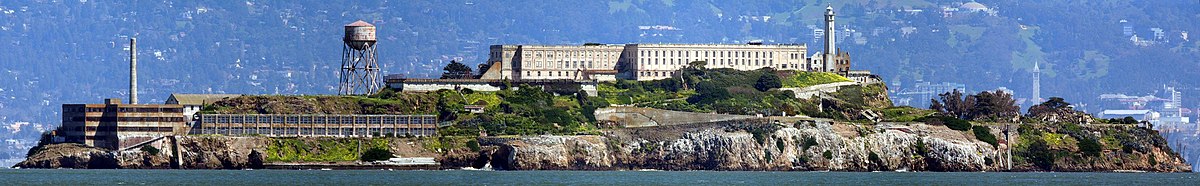
Barker Beach is a small beach and rocky coastal area on the west side of Alcatraz Island, off the coast of San Francisco, California. It lies just south of the long two-story New Industries Building. During the foggy, early morning hours of Friday, January 13, 1939, five inmates - William "Ty" Martin (AZ-370), Henry Young (AZ-244), Rufus McCain (AZ-267), Dale Stamphill (AZ-435), and Arthur "Doc" Barker (AZ-268) - broke out of their D-Block cells and climbed out of a window that had its bars severed in advance, with the sabotage camouflaged with paint and putty. The five men made it to the water's edge and began to look for driftwood to build a raft. In the meantime, their absence was discovered and guards swarmed the island with rifles and machine guns. Dark figures were spotted on the western shore and guards opened fire. Stamphill was shot in the legs multiple times but recovered. Doc Barker took a slug in the head and died several hours later. The remaining three inmates gave up immediately and were recaptured without injury. The beach was later named after Doc Barker by the National Park Service. [1]

Alcatraz Island island in San Francisco, California, United States of America

Alcatraz Island is located in San Francisco Bay, 1.25 miles (2.01 km) offshore from San Francisco, California, United States. The small island was developed with facilities for a lighthouse, a military fortification, a military prison (1828), and a federal prison from 1934 until 1963. Beginning in November 1969, the island was occupied for more than 19 months by a group of Native Americans from San Francisco, who were part of a wave of Native activism across the nation, with public protests through the 1970s. In 1972, Alcatraz became part of a national recreation area and received designation as a National Historic Landmark in 1986.

San Francisco Consolidated city-county in California, United States

San Francisco, officially the City and County of San Francisco, is the cultural, commercial, and financial center of Northern California. San Francisco is the 13th-most populous city in the United States, and the fourth-most populous in California, with 884,363 residents as of 2017. It covers an area of about 46.89 square miles (121.4 km2), mostly at the north end of the San Francisco Peninsula in the San Francisco Bay Area, making it the second-most densely populated large US city, and the fifth-most densely populated U.S. county, behind only four of the five New York City boroughs. San Francisco is also part of the fifth-most populous primary statistical area in the United States, the San Jose–San Francisco–Oakland, CA Combined Statistical Area.

New Industries Building

The New Industries Building is a building on the western end of Alcatraz Island off the coast of San Francisco, USA. It was constructed in 1939 for $186,000 as part of a $1.1 million modernization scheme which also included the water tower, power house, officers quarters and remodeling of the D-block.

Related Research Articles

References

  1. Maravelis, Peter (1 October 2005). San Francisco Noir. Akashic Books. p. 19. ISBN   978-1-888451-91-7 . Retrieved 31 August 2012.

Coordinates: 37°49′35″N122°25′26″W / 37.82639°N 122.42389°W / 37.82639; -122.42389

Geographic coordinate system Coordinate system

A geographic coordinate system is a coordinate system that enables every location on Earth to be specified by a set of numbers, letters or symbols. The coordinates are often chosen such that one of the numbers represents a vertical position and two or three of the numbers represent a horizontal position; alternatively, a geographic position may be expressed in a combined three-dimensional Cartesian vector. A common choice of coordinates is latitude, longitude and elevation. To specify a location on a plane requires a map projection.