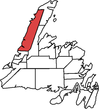
St. Barbe is a defunct provincial electoral district for the House of Assembly of Newfoundland and Labrador, Canada. As of 2011, there were 7,064 eligible voters living within the district. The district was abolished in 2015 and replaced by St. Barbe-L'Anse aux Meadows.

The Great Northern Peninsula is the largest and longest peninsula of Newfoundland, Canada, approximately 270 km long and 90 km wide at its widest point and encompassing an area of 17,483 km2. It is defined as that part of Newfoundland from Bonne Bay northwards around Cape Norman and Cape Bauld and thence southwards to the head of White Bay, bounded by the Gulf of St. Lawrence on the west, the Strait of Belle Isle on the north and the Labrador Sea and White Bay on the east.
Woody Point is a town located in the heart of Gros Morne National Park, on the western coast of Newfoundland. Situated on Bonne Bay, the Town of Woody Point encompasses three areas: Curzon Village, Woody Point and Winterhouse Brook. It has a total population of 244 residents. Woody Point is a Registered Heritage District and has a waterfront with many heritage buildings and four Registered Newfoundland and Labrador Heritage Structures. The community is served by Route 431.

Trout River is a small rural fishing town located on the southern coastal edge of Gros Morne National Park in Newfoundland, near the Tablelands. Trout River was settled in 1815 by George Crocker and his family, who were its only inhabitants until 1880. The community is served by Route 431.
Rocky Harbour is a town located on the western edge of Newfoundland, near the entrance to Bonne Bay. The harbour was previously known as Small Bay or Little Harbour. This town is home to Gros Morne National Park, a World Heritage Site.

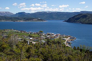
Norris Point is a community in the Canadian province of Newfoundland and Labrador.
Parson's Pond is a community in the province of Newfoundland and Labrador in Canada.

Bonne Bay Marine Station is a marine ecology research and teaching facility on Bonne Bay along Newfoundland's west coast. It offers services to students, researchers, educators and the general public. The station is within Gros Morne National Park, a recognized UNESCO World Heritage Site. The aquarium portion of the facility is open to visitors. Interactive aquariums tours are provided to walk-ins, as well as school and community groups. The tour offers exhibits the latest research while showcasing marine flora and fauna in the station's aquaria and touch tank. Officially opened on 6 Sept, 2002, the Bonne Bay Marine Station is operated by Memorial University of Newfoundland and the Gros Morne Co-operating Association. Funding was provided by Atlantic Canada Opportunities Agency (ACOA) and the Newfoundland and Labrador Provincial Government.
Deadman's Bay is a local service district and designated place in the Canadian province of Newfoundland and Labrador. It is on the Straight Shore of Bonavista Bay near the community of Lumsden. The community is located near fishing grounds, contributing to its diversified and successful fishery despite its exposed, sandy coastline and harsh fall storms.

Frederickton is a designated place in the Canadian province of Newfoundland and Labrador.
Indian Bay is located in Newfoundland, Canada.
Ladle Cove is a designated place in the Canadian province of Newfoundland and Labrador. It is along the Straight Shore on the island of Newfoundland.

Route 430 is a 413-kilometre-long (257 mi) paved highway that traverses the Great Northern Peninsula of Newfoundland in the Canadian province of Newfoundland and Labrador. The route begins at the intersection of Route 1 in Deer Lake and ends in St. Anthony. Officially known as the Great Northern Peninsula Highway, it has been designated as the Viking Trail since it is the main auto route to L'Anse aux Meadows, the only proven Viking era settlement in North America. It is the primary travel route in the Great Northern Peninsula and the only improved highway between Deer Lake and St. Anthony. It is the main access route to the Labrador Ferry terminal in St. Barbe.
Fermeuse is a town in the Canadian province of Newfoundland and Labrador. The town had a population of 266 in the Canada 2021 Census.
South Brook is a town in the Canadian province of Newfoundland and Labrador. It is located in the center region of the island of Newfoundland. The town had a population of 420 in 2021, down from 482 in the Canada 2016 Census.

Green Point is located 12 km north of the town of Rocky Harbour in Gros Morne National Park, on the west coast of Newfoundland. It is the home to a small summer fishing community and a drive-in campground. In 2000, Green Point was designated the Global Stratotype Section and Point (GSSP) representing the division between the Cambrian and the Ordovician systems.
Lomond was a logging town in Newfoundland, Canada, located southeast of Woody Point near Bonne Bay. It developed out of the decline of the fishing industry in the area in the early 20th century and the rise of the logging and pulpwood industries. It was leveled for the creation of the Gros Morne National Park, all of its residents having been resettled as part of the Newfoundland government's general resettlement programme of the 1950s and 1960s. The park's Lomond campground is on the site of the town; by the end of the 20th century, the only structures there were park buildings.
Wiltondale is a settlement on western Newfoundland in the Canadian province of Newfoundland and Labrador. It is located at the intersection between Route 430 and Route 431.

Brig Bay is a local service district and designated place in the Canadian province of Newfoundland and Labrador. It was first mapped by Captain James Cook in September 1764. The name "Brig" was adopted by the French who occupied the bay prior to English occupation. It provided a safe and well-sheltered harbour.
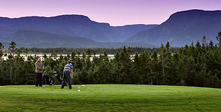
Gros Morne Golf Resort, is a public golf course located near the town of St. Paul's on the Great Northern Peninsula in Newfoundland, Canada.