Balaclava, Renfrew County, Ontario

Last updated

Balaclava
Dispersed rural community
Balaclava Mill.JPG
Balaclava Mill, 2007
Etymology: Named for the Battle of Balaclava
Canada Southern Ontario location map 2.png
Red pog.svg
Balaclava
Location in Southern Ontario
Coordinates: 45°23′26″N76°56′56″W / 45.39056°N 76.94889°W / 45.39056; -76.94889 [1]
Country Canada
Province Ontario
County Renfrew
Municipality Bonnechere Valley
Established1859 (1859)
Dissolved1960s
Rebuilt2016
Elevation
[2]
196 m (643 ft)
Population
 (1987)
  Total2
Time zone UTC-5 (Eastern Time Zone)
  Summer (DST) UTC-4 (Eastern Time Zone)
Forward Sortation Area
K0J
Area codes 613, 343

Balaclava is a dispersed rural community in the township municipality of Bonnechere Valley, Renfrew County, in Eastern Ontario, Canada. [1] [3] [4] [5] [6] It is on the former Ontario Highway 513 (present day Scotch Bush Road) just off Ontario Highway 132 north of the community of Dacre, and at the outlet of Constant Creek, a tributary of the Madawaska River, from Constant Lake, approximately 30 minutes drive time from the town of Renfrew. [4] [5]

Contents

Balaclava known as a "ghost town" is a bustling cottage country today, a come-down from the bustling lumber town of its heyday. It started as a small community named for battle in the Crimean war. Shortly after its founding a dam and sawmill were built and by the 1860s the small hamlet had acquired a blacksmith shop and hotel to go with its permanent residents. In 1903 a sawdust burner was built so that sawdust from the mill would not be dumped in the local river, thereby polluting it. The water-powered sawmill was rebuilt in 1939 after a fire destroyed the mill that had previously occupied the space and continued to [7] operate until 1959. At that time the depletion of available timber had reduced production to uneconomically small amounts. With the loss of the mill the viability of Balaclava as a residential town was also lost. The sawmill was the last water-powered mill to operate in the Province of Ontario. [8]

Balaclava was listed in a book on ghost towns by Ron Brown. [9] Although it makes Balaclava sound like a pristine, deserted ghost town, actually it still has a few residents.

Early history

The place Balaclava was named in 1859 to commemorate a key victory of the British Commonwealth during the Crimean War. The Battle of Balaklava was fought on 25 October 1854 as part of the Siege of Sevastopol. [10] and was commanded by Colonel Thomas Griffith. [11]

In the mid-1800s, a dam was built out of timber towards the east outlet of Constant Lake along, a tributary of Madawaska River. [12] Reports differ regarding the date of construction of the sawmill in Balaclava. The Ontario Law Reports, from 1911, indicate that the mill was erected in the year of 1855. [13] However, an archeological assessment published in 2007, indicated the mill was constructed in 1861. Regardless, two men, named Duncan Ferguson and Donald Cameron, opened the sawmill in Balaclava, joining some of the nearly one-thousand saw mills in Upper Canada at that time. Before long, Cameron sold his portion of the mill to Ferguson. In addition to mill work, Ferguson sold goods in the area. The hamlet was rounded out with a blacksmith, two hotels and a general store, run by Joseph Lagree. [14] As a result of the sawmill, and the timber industry in the Ottawa Valley in the 1800s, Balaclava became a rather busy settlement and bustling pioneer town. [15] The Ottawa Valley was a natural place for a timber industry to develop. The pioneers found the land lush with coniferous trees, specifically spruce and hemlock, and red and white pine trees. European settlers were drawn to the area to cut the trees, create the square cut timber and pulp and the promises of lumber wealth. [16]

The growing town of Balaclava attracted other businessmen, such as William Hunter who built a grist mill two kilometers downstream of the dam. Hunter built his gristmill where the gradient of Constant Creek flattens into an area of poorly drained glacial outwash. [15]

Lawsuit

In 1868, the sawmill and dam were sold to William Richards. The Richards family would-be owners and operators for the following 89 years. In 1911, a pollution-based lawsuit was brought against the sawmill, in the court of judge Latchford, Pembroke and Ottawa. This lawsuit was one of the first pollution-based lawsuits in the Province of Ontario. William Hunter, plaintiff and owner of the local gristmill, complained that between 1904 and 1909, sawdust from the upstream sawmill was negatively affecting his gristmill operations, that Constant Creek was being fouled by the usage of the sawmill, that the flow of water in Constant Creek was impeded, that the defendant disposed of refuse in the creek and that, otherwise, the plaintiff suffered injury as a result. [17] Hunter further complained that the pollution caused damage to his mill pond and that he could not properly run his gristmill, as a result. Richards, the defendant, claimed that he was within his rights based on three reasons: (1) by virtue of a grant from the Crown, (2) right of common law and (3) by easement rights under the Limitations Act.

Citing other law cases, the judge dismantled the Richards' arguments. Part of the rationale was that the original owners of Richards' mill started the operation with one saw. In 1911, the year of the suit, the mill had many saws, shingle and lath mills, an edger and other various appliances. The addition of the number of saws and other pieces of equipment enabled an obvious increase in pollution, which the court argued, surpassed Richards' rights. Further damages had already been paid from 1896 to 1903, for damages and to cover the expense of disposing of the refuse, termed "driftwood" by witnesses consulted in the case. This provided an indication of guilt. Hunter won the suit, Richards was ordered to pay $200 in retribution and was required by order of an injunction to refrain from depositing refuse into the stream. Richards' was given four months to alter his mill to address the refuse situation. [18] This action resulted in the installation the first sawdust burner in the Province of Ontario. [15]

In 1913, an appeal was made in the Ontario Supreme Court, Appellate Division, in an attempt to overturn the verdict. It was summarily dismissed. The appellate magistrate, J.A. Meredith, seemed to side on behalf of the plaintiff in his closing remarks, indicating that sawmill operations create a "nuisance" on the plaintiff's land and the land of many other people and local waterways; causing injury. " The nuisance", he remarked " becomes more and more objectionable and injurious as the surrounding country becomes more settled and the lands affected more highly cultivated and more valuable." Regarding Richard's claim that the Crown grant from 1855 permitted his polluting of the stream, the court commented justice could not be retroactive. In other words, the needs of the early settlers were markedly different than the needs of society in 1913. Therefore, the land grant of 1855 could not also apply as if the case were being tried in an earlier time, as Richards' had requested. The court indicated that privileges were actively being withdrawn and "'trespassing is forbidden'" is becoming the rule rather than the exception." The appeal was dismissed "with costs". [17]

And in an ironic twist of fate, in 1915, it was reported in the Contract Record and Engineering Review that Harry Richards' mill had been destroyed by fire and that he had plans to rebuild the mill. [19]

Concrete Dam

In 1927, the dam, known as the Balaclava Dam, was rebuilt, this time out of concrete. The dam served both the lumbering and sawmill industries. The concrete dam measured 2.5m high by 53m long. [12]

Present day

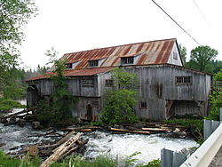
Balaclava is now considered an abandoned or ghost town of Ontario. What remains is "a few houses, an abandoned general store and blacksmith shop, an old dam over which the main road passes and a marvelously intact 19th century sawmill". [20]

In 1983, the Balaclava Dam was purchased by the Ministry of Government Services due to concerns raised about low lake levels and poor dam operations. [12] The dam supported a bridge on Scotch Bush Road which therefore involved the County of Renfrew. In 2012 and 2013, modifications were made to the dam and bridge structure to separate the two. Cost for the project was shared between the Ministry of Natural Resources and the County of Renfrew. [21] This project was undertaken because the aging nature of the structure of the dam. The freeze and thaw cycles could no longer be contained within the 90-year-old concrete. Concerns about the dam's ability to control floods were cited by the Ministry of Natural Resources (MNR), owner of the Balaclava Dam, and owner of over 300 other dams in the Province of Ontario. [22] Further, the MNR cited it needed to be in compliance with requirements of subsection 35(2) of the Fisheries Act. This involved decommissioning Balaclava dam and the roadway above it, removing old structures, building a new and larger dam which was accomplished in 2013. [23] The Richards Family operated the Sawmill and owned the surrounding area until 1957. At that time ownership changed hands to Mr. David Dick & Mrs. Beulah Dick (Walsh). The sawmill continued to operate on water power until 1967. Mr and Mrs Dick owned and operated the general store until the 1970's. Today in 2023 you will see the remnants of the general store have been preserved and restored into a Cottage. Over the years MR. Dick severed and sold off lots of property; of which you will find many modern cottages and home built along constant lake.

Next to the original location of the dam are two heritage structures that "represent early 20th century architecture and economy". One of which is the sawmill, located on the west bank of Constant Creek. The other is a red framed building that front the mill pond on the east side of the creek. [15]

Related Research Articles

<span class="mw-page-title-main">Arnprior</span> Town in Ontario, Canada

Arnprior is a town in Renfrew County, in the eastern portion of Southern Ontario, Canada. It is located 65 km (40 mi) west of Downtown Ottawa, at the confluence of the Madawaska River and the Ottawa River in the Ottawa Valley. Arnprior has experienced significant growth in populations with the widening of the 417 Provincial Highway to four lanes. The town experienced an increase in population by 8.4% from 2011 to 2016, at which time its population was 8,795. The town is a namesake of Arnprior, Scotland, and is known for lumber, hydro power generation, aerospace, farming and its proximity to the National Capital Region.

<span class="mw-page-title-main">York River (Ontario)</span> River in Ontario, Canada

The York River is a river in Renfrew County, Hastings County and Haliburton County in Ontario, Canada. The river is in the Saint Lawrence River drainage basin, and flows from the southern extension of Algonquin Provincial Park to the Madawaska River.

<span class="mw-page-title-main">Petawawa River</span> River in Ontario, Canada

The Petawawa River is a river in the Saint Lawrence River drainage basin in Nipissing District and Renfrew County in eastern and northeastern Ontario, Canada. The river flows from Algonquin Provincial Park to the Ottawa River at the town of Petawawa, and is only one of two major tributaries of the Ottawa River to flow completely freely. The river's name comes from the Algonquian for "where one hears a noise like this", which refers to its many rapids.

<span class="mw-page-title-main">Bonnechere River</span> River in Ontario, Canada

The Bonnechere River is a river in the Saint Lawrence River drainage basin in Nipissing District and Renfrew County in eastern and northeastern Ontario, Canada. The river flows from Algonquin Provincial Park to the Ottawa River east and north of the town of Renfrew. The river's name is thought to come from the French "bonne chère" meaning "plentiful good food".

<span class="mw-page-title-main">John Rudolphus Booth</span> Canadian businessman

John Rudolphus Booth was a Canadian lumber tycoon and railroad baron. He controlled logging rights for large tracts of forest land in central Ontario, and built the Canada Atlantic Railway to extract his logs and to export lumber and grain to the United States and Europe. In 1892, his lumber complex was the largest operation of its kind in the world.

Pakesley is a dispersed rural community and ghost town in geographic Mowat Township in the Unorganized Centre Part of Parry Sound District of Ontario, Canada. Located at the junction of Ontario Highway 522 and the Parry Sound subdivision of the Canadian Pacific Railway, it is named for the Pakeshkag River that drains the local area north to the Pickerel River. Formerly a station and passing track on the CPR, this portion of the line from Bala to Sudbury was opened to traffic June 15, 1908.

Herron's Mills, originally known as Gillies Mills, is a ghost town in the municipality of Lanark Highlands, Lanark County in Eastern Ontario, Canada, near the community of Lanark. It is located on highway 511 between Perth and Calabogie, Ontario.

<span class="mw-page-title-main">Foleyet</span> Place in Ontario, Canada

Foleyet is an unincorporated community in the Unorganized North Part of Sudbury District in Northeastern Ontario, Canada, midway between Chapleau and Timmins on Highway 101. The town was created during the construction of the Canadian Northern Railway (CNR) through the area in the early years of the 20th century.

<span class="mw-page-title-main">John Egan (Canadian politician)</span> Canadian politician

John Egan was an Irish-Canadian businessman and political figure in the Ottawa region.

<span class="mw-page-title-main">Killaloe, Ontario</span> Village in Ontario, Ontario

Killaloe is a town located in Renfrew County, Ontario, Canada in the township of Killaloe, Hagarty and Richards. Geographically it is located in Eastern Ontario. The shores of Golden Lake are located 3 km (1.9 mi) to the east, which is well known for quality angling and year-round recreation. The present day town is located about 1 km (0.62 mi) north of the former townsite of "Old Killaloe". In 2001, the town had a population of 660.

<span class="mw-page-title-main">Daniel McLachlin</span> Canadian politician

Daniel McLachlin was a businessman and political figure in Canada West. He represented Renfrew South in the 1st Canadian Parliament as a Liberal from 1867 to 1869.

The Ottawa, Arnprior and Parry Sound Railway, or OA&PS, is a historic railway that operated in central and eastern Ontario, Canada from 1897 until 1959. It was, for a time, the busiest railway route in Canada, carrying both timber and wood products from today's Algonquin Provincial Park areas, as well as up to 40% of the grain traffic from the Canadian west from Depot Harbour at Parry Sound through to the St. Lawrence River valley.

<span class="mw-page-title-main">South Algonquin</span> Township municipality in Ontario, Canada

South Algonquin is a township municipality in Nipissing District, Ontario, Canada. Located south of Algonquin Provincial Park, it is the sole populated portion of the district that lies south of the traditional dividing line between Northern Ontario and Southern Ontario and is closer connected to Renfrew County as opposed to the core portions of Nipissing District.

<span class="mw-page-title-main">Greater Madawaska</span> Township municipality in Ontario, Canada

Greater Madawaska is an incorporated township in Renfrew County in eastern Ontario, Canada, created on January 1, 2001, through the amalgamation of the Township of Bagot and Blythfield; the Township of Brougham; and the Township of Griffith and Matawatchan. As of 2011, it has a population of 2,518.

<span class="mw-page-title-main">Opeongo Hills</span> Range of hills in Southern Ontario

The Opeongo Hills are a range of hills in Southern Ontario, near Algonquin Provincial Park. The hills stretch from Opeongo Lake in Algonquin Park in the west, along the Madawaska and Opeongo Rivers, towards the Opeongo Colonization Road, and extending towards the Deacon Escarpment, Bonnechere, Ontario, and Dacre in the east. To the east of the Opeongo Hills lie the Madawaska River valley, the Mississippi River Valley, and the Ottawa-Bonnechere Graben along the Ottawa River. Its tallest peak is roughly 7 km northeast of Highway 60. At roughly 586 meters, it is the tallest point in Southern Ontario. The community of Foymount is one of the highest settlements in Southern Ontario.

<span class="mw-page-title-main">Ottawa River timber trade</span> Historic timber industry in the Ottawa Valley of Ontario, Canada

The Ottawa River timber trade, also known as the Ottawa Valley timber trade or Ottawa River lumber trade, was the nineteenth century production of wood products by Canada on areas of the Ottawa River and the regions of the Ottawa Valley and western Quebec, destined for British and American markets. It was the major industry of the historical colonies of Upper Canada and Lower Canada and it created an entrepreneur known as a lumber baron. The trade in squared timber and later sawed lumber led to population growth and prosperity to communities in the Ottawa Valley, especially the city of Bytown. The product was chiefly red and white pine.The Ottawa River being conveniently located with access via the St. Lawrence River, was a valuable region due to its great pine forests surpassing any others nearby. The industry lasted until around 1900 as both markets and supplies decreased, it was then reoriented to the production of wood pulp which continued until the late 1990s and early 2000s.

Black Donald Lake is a reservoir lake in the Township of Greater Madawaska, Renfrew County, and the Township of North Frontenac, Frontenac County, in Eastern Ontario, Canada. It is on the Madawaska River and is part of the Saint Lawrence River drainage basin.

<span class="mw-page-title-main">Centennial Lake (Renfrew County)</span> Reservoir in Renfrew County & Frontenac County, Ontario

Centennial Lake is a reservoir lake in the Township of Greater Madawaska, Renfrew County, and the Township of North Frontenac, Frontenac County, in Eastern Ontario, Canada. It is on the Madawaska River and is part of the Saint Lawrence River drainage basin.

<span class="mw-page-title-main">Calabogie Lake</span>

Calabogie Lake is a reservoir lake in the municipality of Greater Madawaska, Renfrew County, in Eastern Ontario, Canada. It is part of the Saint Lawrence River drainage basin, and is located on the Madawaska River system, in the geographic townships of Bagot and Blythfield.

Robert Conroy was an Irish-born business owner and politician in Quebec. He served as mayor of Aylmer from 1858 to 1860 and from 1866 to 1868. He was considered one of the most prosperous hotel operators and lumber barons in the Ottawa Valley during the 1850s.

References

  1. 1 2 "Balaclava". Geographical Names Data Base . Natural Resources Canada . Retrieved 2010-06-30.
  2. "Google Earth" . Retrieved 2018-09-30.
  3. "Toporama (on-line map and search)". Atlas of Canada . Natural Resources Canada. 12 September 2016. Retrieved 2018-09-30.
  4. 1 2 "Ontario Geonames GIS (on-line map and search)". Ontario Ministry of Natural Resources and Forestry. 2014. Retrieved 2018-09-30.
  5. 1 2 Map 10 (PDF) (Map). 1 : 700,000. Official road map of Ontario. Ministry of Transportation of Ontario. 2018-01-01. Retrieved 2018-09-30.
  6. Restructured municipalities - Ontario map #5 (Map). Restructuring Maps of Ontario. Ontario Ministry of Municipal Affairs and Housing. 2006. Archived from the original on 2019-06-16. Retrieved 2018-09-30.
  7. Bachusky, Johnnie (September 2009). "Into the Void". Travel Magazine. Canadian Geographic Travel. p. 62. Archived from the original on 10 July 2010. Retrieved 2010-06-30.
  8. Keough, Pat; Keough, Rosemarie (17 August 1985). "Meandering Constant Creek Offers Sparkling Valley Tour". Ottawa Citizen.
  9. Brown, Ron (2007). Ontario's ghost town heritage. Erin, Ont: Boston Mills Press. ISBN   978-1-55046-467-2. OCLC   122281028.
  10. Rayburn, Alan (2001). Naming Canada Stories About Place Names. University of Toronto Press. p. 119. ISBN   9780802082930.
  11. Rayburn, Alan (1997). Place Names of Ontario. Toronto: University of Toronto Press.
  12. 1 2 3 Madawaska River Water Management Plan (PDF). Ontario Power Generation. December 2009. p. 60.
  13. Ontario Law Reports (Vol. XXVI ed.). Toronto: Canada Law Book Company, Ltd. 1912. p. 458.
  14. Province of Ontario Gazetteer and Directory 1910-1911. Union Company of Ingersoll. 1910. p. 249.
  15. 1 2 3 4 Swayze, Ken (February 2007). Stage 1 Archeological Assessment of the Balaclava Dam Lot 8 Concession 2 Grattan Twp (PDF). Kinickinick Heritage Consultants. pp. 2, 4, 5. Archived from the original (PDF) on 2014-10-29. Retrieved 2014-10-29.
  16. Lee, David (2006). Lumber Kings and ShantyMen. Toronto: James Lorimer and Company, Ltd. p. 8. ISBN   9781550289220.
  17. 1 2 Tremeear, W.J. (1913). Dominion Law Reports (Volume 12 ed.). Toronto: Canada Law Book Company Ltd. p. 503.
  18. The Ontario Law Reports (Vol. XXVI ed.). Toronto: Canada Law Book Company, Ltd. 1912. pp. 458–460.
  19. "Contract Record and Engineering Review, H.C. MacLean Publications". 29. 1915: 1288.{{cite journal}}: Cite journal requires |journal= (help)
  20. Burpee, Lawrence Johnstone (1967). "Canadian Geographical Journal". 74–75: 47.{{cite journal}}: Cite journal requires |journal= (help)
  21. "Operations Committee Minutes, 8 April 2013" (PDF). Municipal Corporation of the County of Renfrew. Retrieved 9 September 2014.
  22. Mills, Cyndi. "MNR will cover cost for bridge rebuilding". The Daily Observer.
  23. Canadian Environmental Assessment Agency (6 July 2012). "Archived - Replacement of Balaclava Dam, Constant Lake, Renfrew County". www.ceaa-acee.gc.ca. Retrieved 9 September 2014.