
Pine Manor is a census-designated place located off US 41 and Summerlin Rd in Lee County, Florida, United States. The population was 3,785 at the 2000 census. It is part of the Cape Coral-Fort Myers, Florida Metropolitan Statistical Area.

Stenløse is a town and a former municipality in Egedal municipality in Region Hovedstaden on the island of Zealand (Sjælland) in eastern Denmark. The former Stenløse Municipality covered an area of 65 km2 (25 sq mi), and had a total population of 13,384 (2005).

Madzharovo is a small Bulgarian town in the Eastern Rhodopes, part of Haskovo Province, situated on the banks of the river Arda. It has a population of only 590, as of December 2009, making it one of the smallest in the country. The town is the administrative centre of the homonymous Madzharovo Municipality.

The Dongkha la or Donkia Pass is a high mountain pass in the Himalaya connecting Sikkim in India with Tibet.

Am Hart is an U-Bahn station in Munich on the U2.

Naples is a small unincorporated community in Boundary County, Idaho, United States. It lies 11 miles (18 km) south of the city of Bonners Ferry and 23 miles north of Sandpoint, on U.S. Routes 2/95 in the Rocky Mountains. It is also very close to the US-Canada border.

Dongmyo Station is a station on the Seoul Subway Line 1 and Line 6. It is named after a nearby shrine, built during the Joseon dynasty to honor Guan Yu, arguably the most famous Chinese military general from the Three Kingdoms era.

Sulin is a village in the administrative district of Gmina Kłecko, within Gniezno County, Greater Poland Voivodeship, in west-central Poland. It lies approximately 7 kilometres (4 mi) south of Kłecko, 12 km (7 mi) west of Gniezno, and 41 km (25 mi) north-east of the regional capital Poznań.

Tamridjet is a town in northern Algeria. It is in the Souk El Tenine District of Béjaïa Province.
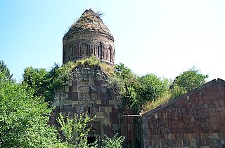
Chinari is a town in the Tavush Province of Armenia.The town lies very close to the Armenia-Azerbaijani border, and is the town closest to the Khoranashat monastery, which is northeast of the town on a hill. the monastery is only feet away from the border, and is abandoned.

Chiva is a village in the Vayots Dzor Province of Armenia.

Mahmudlu is a village in the Qubadli Rayon of Azerbaijan.
Kolonia Kamieńczykowska is a village in the administrative district of Gmina Sterdyń, within Sokołów County, Masovian Voivodeship, in east-central Poland.
Mzdowiec is a settlement in the administrative district of Gmina Kępice, within Słupsk County, Pomeranian Voivodeship, in northern Poland. It lies approximately 11 kilometres (7 mi) south-west of Kępice, 37 km (23 mi) south-west of Słupsk, and 124 km (77 mi) west of the regional capital Gdańsk.

Tlidjene is a town and commune in Tébessa Province in north-eastern Algeria.
Chiflik is a village in Kardzhali Municipality, Kardzhali Province, southern Bulgaria.
Strazhevtsi, Postalar in Turkish and Стражевци in Bulgarian is a village in Kardzhali,Kircaali in Turkish and Кърджали in Bulgarian) Municipality, Kardzhali Province, southern Bulgaria.
Strahil voyvoda is a village in Kardzhali Municipality, Kardzhali Province, southern Bulgaria.
West Jefferson is an unincorporated community in Williams County, in the U.S. state of Ohio.
Capulin Peak is a summit in Rio Arriba County, New Mexico. It reaches an elevation of 9199 feet / 2804 meters. Its former name in the Tewa language of the nearby Puebloan peoples was Abepin. Its Spanish name was Cerro Capulin, Capulin meaning Choke Cherry. The Armijo Route of the Old Spanish Trail ran westward at the foot of the peak at its south. This route is now closely followed or paralleled by New Mexico, New Mexico State Road 96.


