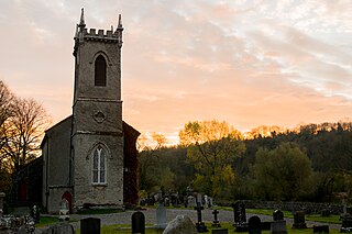
Saint Peter's Church, Ennisnag is a church of the United Dioceses of Cashel and Ossory and the ecclesiastical province of the United Provinces of Dublin and Cashel in the (Anglican) Church of Ireland. The church lies beside the Kings River, one mile north of Stoneyford village in County Kilkenny, Ireland. Located in the townland of Ennisnag, in the barony of Shillelogher.

Hugginstown is a small village and townland in south County Kilkenny, Ireland. The local Gaelic Athletic Association club, Carrickshock GAA, play their home games in the village.
Newtowncashel is a village located near Lough Ree in County Longford, Ireland. Newtowncashel won the Irish Tidy Towns Competition in 1980.

Boston is a village in north County Clare, Ireland. It is situated near Lough Bunny, off the R460 road from Corofin to Gort, at the northeastern edge of the Burren National Park, and close to the border with County Galway. It is at the intersection of the townlands of Kylecreen, Drumnadeevna, and Rockvale, which are in the civil parish of Kilkeedy.
Herbertstown is a village in south-eastern County Limerick, Ireland. It is part of the ecclesiastical parish of "Hospital and Herbertstown", in the Roman Catholic Archdiocese of Cashel and Emly. Herbertstown is in the centre of the electoral division of Cahercorney stretching from Ballingoola in the north-east, Ballyloundash in the east and Kilcullane in the south.

Kilfane is a combination of two townlands located outside of Thomastown in County Kilkenny, Ireland. It is made up of the townlands of Kilfane East and West with a total area of 75 acres (0.30 km2). Located in the barony of Gowran, Kilfane gives its name to the wider civil parish which contains 16 townlands. It is in the Roman Catholic parish of Tullaherin.
Ballymurreen, also written Ballymoreen, is a civil parish and an electoral division in County Tipperary, Ireland. It is one of 21 civil parishes in the barony of Eliogarty.

The barony of Callan is a barony in the west of County Kilkenny, Ireland. The barony is 22.9 square kilometres (8.8 sq mi) in size. It is one of 12 baronies in County Kilkenny. Unusually for a barony, it contains only two civil parishes which together comprise 65 townlands. The chief town is Callan. The barony is bordered by the baronies of Shillelogher to the north and by Kells to the south. The N76 road bisects the barony. Notable features include Callan Motte and Callan Augustinian Friary.
Smallcounty or ‘’’Small County’’’ is a historical barony in County Limerick, Ireland. Settlements in the barony include Hospital, Herbertstown, Fedamore, Knockainy, and Six-Mile-Bridge.

Gowran is a barony in the east of County Kilkenny, Ireland. The size of the barony is 430.5 square kilometres (166.2 sq mi). There are 35 civil parishes in Gowran. The chief town today is Gowran. The barony contains the ecclesiastical sites of Kilfane and Duiske Abbey The barony of Gowran is situated in the east of the county between the baronies of Fassadinin to the north, the baronies of Kilkenny, Shillelogher and Knocktopher to the west, and the barony of Ida is to the south. It borders County Carlow to the east. The M9 motorway bisects the barony.
Kilcullane is a civil parish and townland located in County Limerick, Ireland. The civil parish is in the barony of Smallcounty. It is located in east County Limerick near the village of Bruff. The north-eastern part of the parish borders the parish of Ballinard.
Moycullen is a Gaeltacht civil parish in the ancient barony of the same name. It is located in the western shore of Lough Corrib in County Galway, Ireland and is around 4 miles (6.4 km) north-west of the city of Galway on the road to Oughterard. The parish contains 27,294 statute acres. According to Lewis's survey of 1837, "The land is of very indifferent quality; and there is a large quantity of reclaimable waste and bog.". The parish gets its name from the church, now in ruins, that is situated around 1 mile (1.6 km) to the east of the village, in the townland of Moycullen itself.
Kilbeacon is a civil parish in the ancient barony of Knocktopher. It is located in the south of County Kilkenny, Ireland and is around 22 miles (35 km) south of the city of Kilkenny on the road to Waterford. The parish contains 3,151 statute acres. According to Lewis's survey of 1837, "At Earlsrath was a large fort, encompassed by a fosse and a bank about 20 feet high.". In 1833, there were 383 inhabited houses in the parish; of these, 270 families were primarily engaged in agriculture, 61 in manufactures or crafts, 52 in other. The total population was 2284 people.
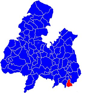
The barony of Shillelogher is a barony in the west of County Kilkenny, Ireland. The barony is 36,684 acres (148.45 km2) in size. It is one of 12 baronies in County Kilkenny. There are 19 civil parishes in Shillelogher, made up of 109 townlands. The chief town is Bennettsbridge. Shillelogher lies at the centre of the county, with the baronies of Crannagh and Kilkenny to the north (whose chief towns are Freshford and Kilkenny, and the barony of Gowran to the east. It is borders County Tipperary to the west. The N76 road bisects the barony. The river Nore flows through the barony. Danesfort Church is located in Shillelogher.
Kilcommon, is a civil parish in the ancient barony of Ballinacor South in County Wicklow, Ireland. The parish is centered on the village of Tinahely. It is divided into 28 townlands
Killallon civil parish is situated in the barony of Fore, County Meath. It has an area of 7,626 acres.
Castleknock is a civil parish and a townland located in the south-western corner of the modern county of Fingal, Ireland. The civil parish is part of the ancient barony of Castleknock. It is centred on the suburban village of Castleknock. The townland of Castleknock itself is the location of the eponymous "Cnucha's Castle" – Castleknock Castle. The town with the biggest population in the parish is Blanchardstown. In geology, the parish rests on a substratum of limestone and comprises 2943 statute acres, the whole of which is arable land.
Ballinard is a small townland in the civil parish of Tullagh, County Cork, Ireland. The townland is approximately 0.9 square kilometres (0.35 sq mi) in area, and had a population of 9 people as of the 2011 census.
Leixlip is a civil parish and a townland located in the north-eastern corner of County Kildare, Ireland. The civil parish is mainly in the ancient barony of Salt North with a small part in the neighbouring barony of Newcastle. It is centred on the town of Leixlip. In geology, the parish rests on a substratum of limestone, and contains chalybeate springs. It lies at the confluence of the River Liffey and the Rye Water.
Clonsilla or "Clonsillagh" is a civil parish and a townland located in the south-western corner of the modern county of Fingal, Ireland. The civil parish is part of the ancient barony of Castleknock. It is centred on the suburban village of Clonsilla. In geology, the parish rests on a substratum of limestone and comprises 2943 statute acres, the whole of which is arable land. It is roughly bounded to the north by the old "Navan Road" – the modern N3; to the east by the civil parish of Castleknock; to the south by the River Liffey; to the south-east by the civil parish of Leixlip, chiefly in County Kildare, and to the north-west by the civil parish of Dunboyne in County Meath.

