
County Westmeath is a county in Ireland. It is in the province of Leinster and is part of the Midlands Region. It originally formed part of the historic Kingdom of Meath. It was named Mide because the kingdom was located in the geographical centre of Ireland. Westmeath County Council is the administrative body for the county, and the county town is Mullingar. At the 2016 census, the population of the county was 88,770.
Innisfallen or Inishfallen is an island in Lough Leane; one of the three Lakes of Killarney in County Kerry, Ireland.
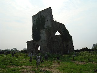
Abbeylara is a village in the easternmost portion of County Longford, Ireland, located about three kilometers east of Granard on the R396 regional road. Its name is derived from a monastery, the great Abbey of Lerha, founded in 1205 by Hiberno-Norman magnate, Risteárd de Tiúit, for Cistercian monks. The monastery was dissolved in 1539, although its ruins are still apparent on approach to the village. An ancient earthwork, the Duncla or Black Pig's Dyke, which runs south-eastwards from Lough Gowna to Lough Kinale, goes through the larger parish of Abbeylara, and passes about one kilometre north of the village.

Ballymore is a rugby union stadium situated in Herston, a suburb of Brisbane, Australia. It is the headquarters of Queensland Rugby Union and the home ground of the Brisbane City team in the National Rugby Championship. It is also used as a training facility for the Queensland Reds and Australian Wallabies rugby teams.

Whiteabbey is a townland in Newtownabbey, north of Belfast in County Antrim, Northern Ireland.
Greyabbey or Grey Abbey is a small village, townland and civil parish located on the eastern shores of Strangford Lough, on the Ards Peninsula in County Down, Northern Ireland.

Rathmullan is a small seaside village on the Fanad Peninsula in County Donegal, Ireland. It is situated on the western shore of Lough Swilly, 11 km (7 miles) north-east of Ramelton and 12 km (7.5 miles) east of Milford. Rathmullan serves as an important historical village as it was the scene of the Flight of the Earls in 1607, a major turning point in Irish history.
Ballymore Castle in Lawrencetown, County Galway, Ireland was originally a 15th-century tower house belonging to O'Madden. A house was added in 1620, and the castle has been much altered since then.
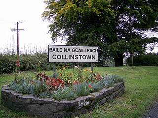
Collinstown is a village in north County Westmeath, situated on the R395 regional road overlooking Lough Lene. It lies 18 km (11 mi) northeast of the county town of Mullingar and had a population of 356.

Attymass is a village in County Mayo, Ireland.

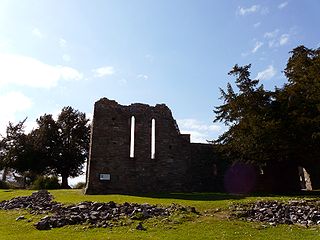
Situated between Lough Glore and Lough Lene, and Lough Ban, Ireland, the Hill of Ben dominates the valley where Fore abbey was built by De Lacy of the Lord of Meath family for the French Benedictine monks. It rises sharply among the other surrounding hill that interlace with the many loughs of Westmeath. Local legend has it that Saint Patrick's successor, named Benigne, is said to have preached from the hill to bring the gospel to local communities.

Ballymore is a village in County Westmeath, Ireland, on the R390 road between Athlone and Mullingar. The historic Hill of Uisneach is nearby. The village was known in medieval times as the medieval borough of Ballymore Lough Sewdy, or Loughsewdy, after the nearby lake, the site of an ancient bruighean, or hostel.
Events from the year 1540 in Ireland.
Ballycong is a small townland southeast of Ballina, located between the River Moy and the Ox Mountains. Ballycong townland has an area of approximately 580 acres (0.91 sq mi), and had a population of 28 people as of the 2011 census.
The Cálraighe were a population-group found mostly in northern Connacht as well as County Westmeath and County Longford. They were purported descendants of Lugaid Cal, son of Daire Sirchrechtaig, who was himself a supposed descendant of Lugaid mac Itha, a first cousin of Míl Espáine.

Fore is a barony in northern County Westmeath, Ireland. It was formed by 1672.

Poyntzpass is a small village on the border between southern County Armagh and County Down in Northern Ireland. It is situated in the civil parish of Ballymore and the historic barony of Orior Lower within the Armagh City and District Council area. It had a population of 552 people in the 2011 Census. It was a part of the South Armagh constituency and is now part of the Newry and Armagh constituency, and was one of the places in South Armagh where the Ulster Covenant could be signed.

Holy Trinity Abbey is a former medieval Premonstratensian priory and National Monument located in Lough Key, Ireland.

Kildermot Abbey is a former Premonstratensian Priory and National Monument located in County Mayo, Ireland.

