
County Mayo is a county in Ireland. In the West of Ireland, in the province of Connacht, it is named after the village of Mayo, now generally known as Mayo Abbey. Mayo County Council is the local authority. The population was 137,231 at the 2022 census. The boundaries of the county, which was formed in 1585, reflect the Mac William Íochtar lordship at that time.

Westport is a town in County Mayo in Ireland. It is at the south-east corner of Clew Bay, an inlet of the Atlantic Ocean on the west coast of Ireland. Westport is a tourist destination and scores highly for quality of life. It won the Irish Tidy Towns Competition three times in 2001, 2006 and 2008. In 2012 it won the Best Place to Live in Ireland competition run by The Irish Times.

Athea is a village in west County Limerick, Ireland. Athea has a Roman Catholic church, and is the centre for the parish of Athea, which encompasses several nearby townlands.

Aughagower or Aghagower is a small village in rural County Mayo in western Ireland. It is located about 6 km from Westport. Aughagower has around 40 houses, 1 pub and a shop, with a clear view of Croagh Patrick from Reek View. It also forms the centre of a parish of the same name which covers an area of 86.1 square miles. The village is known for its links to Saint Patrick and Tóchar Phádraig, the pilgrimage route from Ballintubber Abbey to Croagh Patrick.
Lahardane, also sometimes spelled Lahardaun, is a village in the parish of Addergoole, County Mayo, Ireland, adjacent to Lough Conn and to Nephin, and close to the towns of Crossmolina, Castlebar and Ballina. The 2016 census recorded a population of 178.

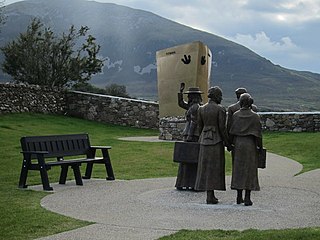
Murrisk is a village in County Mayo, Ireland, on the south side of Clew Bay, about 8 km west of Westport and 4 km east of Lecanvey.

Neale, also known as the Neale, is a small village in the south of County Mayo in Ireland. It is located near the villages of Cong 4 km to the south-west, Cross 4 km to the south and the town of Ballinrobe about 5 km to the north.

Attymass is a village and civil parish in County Mayo, Ireland.

Burrishoole Friary was a Dominican friary in County Mayo, Ireland. Its ruin is a National Monument.

Farran is a village in County Cork, Ireland, in the parish of Ovens. It lies on the southside of the River Lee. Farran is 12 miles (19 km) west from Cork City on the N22 road.
Ballycong is a small townland southeast of Ballina, located between the River Moy and the Ox Mountains. Ballycong townland has an area of approximately 580 acres (0.91 sq mi), and had a population of 28 people as of the 2011 census.

Ballina is a town in north County Mayo, Ireland. It lies at the mouth of the River Moy near Killala Bay, in the Moy valley and Parish of Kilmoremoy, with the Ox Mountains to the east and the Nephin Beg mountains to the west. The town occupies two baronies; Tirawley on the west bank of the Moy River, and Tireragh, a barony within County Sligo, on its east banks. At the 2016 census, the population of Ballina was 10,171.

Dromiskin Monastery is a medieval monastery and National Monument located in Dromiskin, County Louth in Ireland.

Errew Abbey is a former Augustinian monastery and National Monument located in County Mayo, Ireland.
Barnacahoge Cashel, is a stone ringfort (cashel) and National Monument located in County Mayo, Ireland.

Turlough Abbey is a former monastery and National Monument located in County Mayo, Ireland.

Burriscarra Abbey is a former Carmelite Priory and National Monument located in County Mayo, Ireland.

Kilmalkedar is a medieval ecclesiastical site and National Monument located in County Kerry, Ireland.
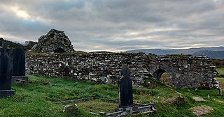
Kilgeever Abbey or church is situated just outside Louisburgh in the parish of Kilgeever, in the barony of Murrisk, County Mayo. The site consists of a ruined church, a graveyard and a holy well, where pilgrimages or patterns take place. The site is part of the Clew Bay Archaeological Trail. The church is a multi-period church containing a late medieval doorway. The graveyard on the site is suggested to be from Early Christian times and continues to be in use. Within the graveyard, there is a pillar stone incised with a cross, the graveyard also contained a free-standing stone and a portable stone cross with incised crosses which are now in private ownership.
