Ballysteen

Last updated
Beagh Castle, near Ballysteen Beagh castle - geograph.org.uk - 134431.jpg
Beagh Castle, near Ballysteen

Ballysteen (Irish : Baile Stiabhna) is a small village and townland in County Limerick, Ireland. [1] It is located in the civil parish of Iveruss and the historical barony of Kenry. [1]

Evidence of ancient settlement in the area includes a number of ringfort, enclosure and tower house sites in the townlands of Ballysteen, Beagh, Ballinvoher and Issane. [2] Beagh Castle, an outpost fortification built in the 13th century by the FitzGerald family, [3] is located close to Ballysteen village. [4] Ballysteen House, an 18th-century country house, [5] is reputedly built on the site of the former Ballysteen Castle. [6] The Catholic church in Ballysteen, which dates to 1861, [7] is in the Roman Catholic Diocese of Limerick. [8] The ruins of a 15th or 16th-century chapel and churchyard are nearby in Beagh townland. [9] [10] Ballysteen's Carnegie library (constructed c.1905) was restored in the early 21st century and is now a community and heritage centre. [11]

Local sports clubs include Ballysteen GAA (a Gaelic Athletic Association club which fields teams in competitions organised by Limerick GAA), [12] and Ballysteen AFC (an association football (soccer) club which participates in the Limerick Desmond League). [13] The local primary school, Ballysteen National School, had an enrollment of 26 pupils as of 2024. [14]

Related Research Articles

<span class="mw-page-title-main">Kinvara</span> Village in south County Galway, Ireland

Kinvara or Kinvarra is a sea port village in the southwest of County Galway, Ireland. It is located in the civil parish of Kinvarradoorus in the north of the barony of Kiltartan. Kinvarra is also an electoral division.

<span class="mw-page-title-main">Askeaton</span> Town in County Limerick, Ireland

Askeaton is a town in County Limerick, Ireland. The town is built on the banks of the River Deel which flows into the Shannon Estuary 3 km to the north. Askeaton is on the N69 road between Limerick and Tralee; it is 25 km west of Limerick and 8 km north of Rathkeale. The town is in a townland and civil parish of the same name.

<span class="mw-page-title-main">Ballybunion</span> Seaside resort in County Kerry, Ireland

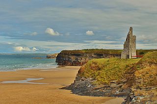
Ballybunion or Ballybunnion is a coastal town and seaside resort in County Kerry, Ireland, on the Wild Atlantic Way, 15 km (9 mi) from the town of Listowel. As of the 2022 census, Ballybunion had a population of 1,618.

<span class="mw-page-title-main">Rathkeale</span> Town in County Limerick, Ireland

Rathkeale is a town in west County Limerick, in Ireland. It is 30 km (18 mi) southwest of Limerick city on the N21 road to Tralee, County Kerry, and lies on the River Deel. The town is in a townland and civil parish of the same name.

<span class="mw-page-title-main">Ballingarry, County Limerick</span> Village in County Limerick, Ireland

Ballingarry is a village in County Limerick, Ireland. It is located near the village of Granagh and between the towns of Rathkeale and Kilmallock on the R518 road. Ballingarry lies in a civil parish of the same name, and within the ecclesiastical parish of Ballingarry-Granagh in the Roman Catholic Diocese of Limerick. The village had a population of 570 as of the 2022 census, up from 521 at the 2016 census.

<span class="mw-page-title-main">Hugginstown</span> Village in County Kilkenny, Ireland

Hugginstown is a small village and townland in south County Kilkenny, Ireland. The local Gaelic Athletic Association club, Carrickshock GAA, play their home games in the village.

<span class="mw-page-title-main">Meelick, County Clare</span> Village near Limerick city, Ireland

Meelick is a small village and townland in County Clare, Ireland, situated a few kilometres north of Limerick city in the Mid-West Region.

<span class="mw-page-title-main">Ballymacelligott</span> Civil parish in Munster, Ireland

Ballymacelligott is a civil parish in the north of County Kerry in Ireland. It is situated 7 kilometres (4.3 mi) east of Tralee in the historical barony of Trughanacmy.

Newtowncashel is a village located near Lough Ree in County Longford, Ireland. Newtowncashel won the Irish Tidy Towns Competition in 1980.

<span class="mw-page-title-main">Haggardstown</span> Townland in Leinster, Ireland

Haggardstown is a townland and civil parish located in the barony of Upper Dundalk, on the southern outskirts of Dundalk, County Louth, Ireland. The civil parish of Haggardstown lies on the shore of Dundalk Bay, north of the estuary of the River Fane, and includes the village of Blackrock and Dundalk Golf Club.

<span class="mw-page-title-main">Ballindrait</span> Village in County Donegal, Ireland

Ballindrait is a townland, village and census town in County Donegal, Ireland. Located near Lifford, the village and townland of Ballindrait is in the civil parish of Clonleigh and the barony of Raphoe North. The Burn Dale flows through the centre of Ballindrait.

<span class="mw-page-title-main">Ballingarry, North Tipperary</span> Civil parish in County Tipperary, Ireland

Ballingarry is a civil parish and a townland in the barony of Ormond Lower, County Tipperary in Ireland. It is located on the N52 between Borrisokane and Birr. Ballingarry townland has an area of 5.3 square kilometres (2 sq mi), and had a population of 170 people as of the 2011 census.

<span class="mw-page-title-main">Firies</span> Village in Munster, Ireland

Firies is a village in County Kerry, Ireland in the historical barony of Magunihy. It is situated midway between the hub towns of Killarney (14.5 km), Tralee (16 km), Castleisland (16 km) and Killorglin (13 km). It is on the R561 road between Farranfore and Castlemaine. The population at the 2016 census was 558. There are two principal rivers, namely the Maine and its chief tributary, the Brown Flesk.

Ballyhahill is a village and townland in County Limerick, Ireland. As of the 2016 census, the village had a population of 146 people. It is 40 km west of Limerick city. The White River flows to the east of the village.

<span class="mw-page-title-main">Knockainey</span> Civil parish in County Limerick, Ireland

Knockainey or Knockainy is a civil parish and village in County Limerick, Ireland. It is in the historical barony of Smallcounty, between the towns of Hospital and Bruff.

<span class="mw-page-title-main">Ballyhar</span> Townland in County Kerry, Ireland

Ballyhar is a townland and electoral division in County Kerry, Ireland. Located in the historical barony of Magunihy and in the civil parish of Kilcredane, the townland of Ballyhar has an area of approximately 1.2 square kilometres (0.5 sq mi).

<span class="mw-page-title-main">Cordal</span> Village in County Kerry, Ireland

Cordal is a village and electoral division in County Kerry, Ireland. The townlands of Cordal East and Cordal West are in the civil parish of Ballincuslane and the historical barony of Trughanacmy. As of the 2011 census, Cordal East and Cordal West had populations of 115 and 117 residents respectively.

<span class="mw-page-title-main">Kilfinny</span> Parish and townland in County Limerick, Ireland

Kilfinny is a civil parish and townland in County Limerick, Ireland. It is close to Adare and Croom in the historical barony of Connello Upper.

Castletown, also known as Castletown Conyers, is an electoral division, townland and village in County Limerick, Ireland. The townland, which had a population of 143 as of the 2011 census, is in the civil parish of Corcomohide and the historical barony of Connello Upper.

Killeenagarriff is a civil parish in the historical barony of Clanwilliam in County Limerick, Ireland. Settlements in Killeenagarriff include the town of Annacotty, and population centres at Ahane and Barringtonsbridge.

References

  1. 1 2 "Baile Stiabhna / Ballysteen". logainm.ie. Placenames Database of Ireland. Retrieved 19 April 2024.
  2. Record of Monuments and Places as Established under Section 12 of the National Monuments (Amendment) Act 1994 - County Limerick. Dublin: National Monuments and Historic Properties Service. 1997.
  3. "Heritage - Places of Historical Interest on the Shannon Estuary Way". shannonestuaryway.ie. The Shannon Estuary Way. Retrieved 19 April 2024.
  4. "Beagh Castle Holiday Cottages & Iverus Café". limerick.ie. Limerick City and County Council. Retrieved 19 April 2024.
  5. "Ballysteen House, Keenoge, Limerick". buildingsofireland.ie. National Inventory of Architectural Heritage. Retrieved 19 April 2024.
  6. Westropp, Thomas Johnson (1906). "The Ancient Castles of the County of Limerick (Central and South-Eastern Baronies)". Proceedings of the Royal Irish Academy: Archaeology, Culture, History, Literature. 26: 156. JSTOR   25502742.
  7. "Saint Patrick's Catholic Church, Calliaghstown, Ballysteen, Limerick". buildingsofireland.ie. National Inventory of Architectural Heritage. Retrieved 19 April 2024.
  8. "St. Patrick's Church Ballysteen". askeatonballysteen.ie. Askeaton Ballysteen Parish. Retrieved 19 April 2024.
  9. Lewis, Samuel, ed. (1837). "Iverus". A Topographical Dictionary of Ireland . Dublin: Lewis.
  10. Westropp, Thomas Johnson (1904). "A Survey of the Ancient Churches in the County of Limerick". Proceedings of the Royal Irish Academy: Archaeology, Culture, History, Literature. 25: 388, 389. JSTOR   25502727.
  11. "Ballysteen Carnegie Library re-opens on proud day for local community". ilovelimerick.ie. Retrieved 19 April 2024.
  12. "Ballysteen GAA - History". ballysteengaa.ie. Retrieved 19 April 2024.
  13. "Limerick Desmond Football League - Ballysteen AFC". limerickdesmondfootballleague.com. Retrieved 19 April 2024.
  14. "Directory Page - Ballysteen N S". gov.ie. Department of Education. Retrieved 19 April 2024.

52°38′47″N8°57′08″W / 52.6464°N 8.9521°W / 52.6464; -8.9521