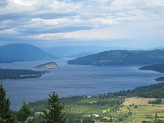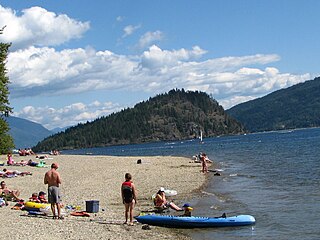
Salmon Arm is a city in the Columbia Shuswap Regional District of the Southern Interior of the Canadian province of British Columbia that has a population of 17,706 (2016). Salmon Arm was incorporated as a municipal district on May 15, 1905. The city of Salmon Arm separated from the district in 1912, but was downgraded to a village in 1958. In 1970, the city of Salmon Arm once again reunited with the District Municipality. Salmon Arm once again became a city in 2005, and is now the location of the head offices of the Columbia-Shuswap Regional District. It is a tourist town in the summer, with many beaches, camping facilities and house boat rentals. Salmon Arm is home to the longest freshwater wooden wharf in North America.

The Columbia–Shuswap Regional District is a regional district in the Canadian province of British Columbia, located in the Southern Interior region on the Trans-Canada Highway between Vancouver and Calgary, Alberta. The regional district borders the Province of Alberta across the Rocky Mountains.

Shuswap Lake is a lake located in the southern interior of British Columbia, Canada that drains via the Little Shuswap River into Little Shuswap Lake. Little Shuswap Lake is the source of the South Thompson River, a branch of the Thompson River, a tributary of the Fraser River. It is at the heart of a region known as the Columbia Shuswap or "the Shuswap", noted for its recreational lakeshore communities including the city of Salmon Arm. The name "Shuswap" is derived from the Shuswap or Secwepemc First Nations people, the most northern of the Interior Salish peoples, whose territory includes the Shuswap. The Shuswap call themselves /ʃǝxwépmǝx/ in their own language, which is called /ʃǝxwepmǝxtʃín/, but the ethnonym's original meaning is now lost.

Shuswap is a provincial electoral district for the Legislative Assembly of British Columbia, Canada.

North Okanagan—Shuswap is a federal electoral district in the province of British Columbia, Canada, that has been represented in the House of Commons of Canada since 1988. The district has been sporadically known as Okanagan—Shuswap.
Columbia-Shuswap C is a regional district electoral area in the Columbia-Shuswap Regional District, British Columbia, Canada. The electoral area is located in south-central BC between the Main Arm and Salmon Arm of Shuswap Lake. It has no governmental or administrative function and only describes voting boundaries for the election of rural representatives to the regional district board.

Shuswap Lake Provincial Park is a provincial park in British Columbia, Canada.

Shuswap River Islands Provincial Park is a provincial park in British Columbia, Canada. The park was established as a result of the Okanagan-Shuswap Land and Resource Management Plan. Size: 1.85 km2.

Skookumchuck Rapids Provincial Park is a provincial park in British Columbia, Canada, located on the Shuswap River just below the outlet of Mabel Lake. This park was established as a result of the Okanagan-Shuswap Land and Resource Management Plan.
Sunnybrae Provincial Park is a provincial park in British Columbia, Canada, located on the northern side of the Salmon Arm of Shuswap Lake, near the city of Salmon Arm. Sunnybrae is a day use park with washrooms, picnic tables, playground and swimming area.

The Secwépemc, known in English as the Shuswap people, are a First Nations people residing in the interior of the Canadian province of British Columbia. They speak one of the Salishan languages, known as Secwepemc or Shuswap.
The Neskonlith Indian Band is a First Nations government in the Canadian province of British Columbia located in the Shuswap district east of Kamloops. It is a member of the Shuswap Nation Tribal Council, one of two main governmental bodies of the Secwepemc (Shuswap) people. It was created when the government of the Colony of British Columbia established an Indian Reserve system without the consent and without consultation with the indigenous population of the colony, in the 1860s. The Neskonlith Indian Band is named after Chief Neskonlith, and co-established by Chief Careguire, Chief Neskonlith's father. The original reserve created is what is known as the Neskonlith Douglas Reserve.
The Shuswap Nation Tribal Council is a First Nations Tribal Council in the Canadian province of British Columbia. Based in the Thompson and Shuswap Districts of the Central Interior, although including one band on the upper Columbia River in the East Kootenay region. It is one of two tribal councils of the Secwepemc people, the other being the Northern Shuswap Tribal Council of the Cariboo region farther to the north. The council is based in Kamloops, British Columbia.
The Shuswap Indian Band is a member government of the Shuswap Nation Tribal Council and also of the Ktunaxa Kinbasket Tribal Council, located in the East Kootenay region of the Canadian province of British Columbia. Its main reserve, the Shuswap Indian Reserve, is located one mile north of Invermere, British Columbia in the Columbia Valley region of the Rocky Mountain Trench on the upper Columbia River, on the other side of the Selkirk Mountains from other Secwepemc bands. It was created when the government of the then-Colony of British Columbia established an Indian Reserve system in the 1860s. Though a member of the Ktunaxa Kinbasket Tribal Council and intermarried with the Ktunaxa bands in the same region, the members of the band are ethnically Secwepemc (Shuswap).

The Shuswap Highland is a plateau-like hilly area of 14,511 km2 (5,603 sq mi) in British Columbia, Canada. It spans the upland area between the Bonaparte and Thompson Plateaus from the area of Mahood Lake, at the southeast corner of the Cariboo Plateau, southeast towards the lower Shuswap River east of Vernon in the Okanagan.

Spallumcheen is a district municipality in the Canadian province of British Columbia. Located in the Okanagan region between Vernon and Enderby, the township had a population of 5,055 and land area of 255.77 square kilometres (98.75 sq mi) in the Canada 2011 Census. The district, whose official name is the Township of Spallumcheen and which is the oldest rural municipality in the British Columbia Interior, consists primarily of agricultural land surrounding the separately incorporated City of Armstrong. Both Spallumcheen and Armstrong are member municipalities of the Regional District of North Okanagan.

Eagle Bay is a designated place located on the Shuswap Highland Peninsula on the southern shore of Shuswap Lake in British Columbia, Canada.

The Shuswap Country, or simply the Shuswap and called Secwepemcúl̓ecw in Secwepemctsín, is a term used in the Canadian province of British Columbia to refer to the environs of Shuswap Lake. The upper reaches of the Shuswap basin, southeast of Shuswap Lake and northeast of the Okanagan, are generally considered to be part of Okanagan or of the Monashee Country rather than "the Shuswap". Roughly defined, the Shuswap Country begins on its west at the town of Chase, located on Little Shuswap Lake, west of which is the South Thompson area of the Thompson Country, and includes Adams Lake to the northwest of Shuswap Lake as well as communities in the Eagle River area as far as Craigellachie and/or Three Valley Gap, which is at the summit of Eagle Pass, beyond which eastwards is the Columbia Country.


