
Oku is a subdivision in North West Region,, Cameroon. The term Oku also refers to the people who live in this region ruled by a Paramount Monarch [HRM King Ngum IV. Ngum Ernest Merlin Shang] and the primary language that they speak. Oku is a rural area containing about 36 villages with the population of about 180,000 inhabitants. The nearest really large city is Bamenda, but Kumbo, which is closer, is large enough to have telephone lines and a Baptist-run hospital. Oku also has a Sub-divisional hospital. However, three mobile telephone networks are available in Oku. As such, mobile internet facilities are available.
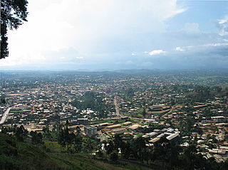
Bamenda, also known as Abakwa and Mankon Town, is a city in northwestern Cameroon and capital of the Northwest Region. The city has a population of about six hundred thousand people and is located 366 km (227 mi) north-west of the Cameroonian capital, Yaoundé. Bamenda is known for its cool climate and scenic hilly location.

Bafut is a town located in a modern commune in Cameroon, it is also a traditional fondom. It is located in the Mezam Department, which in turn is located in the Northwest Province.
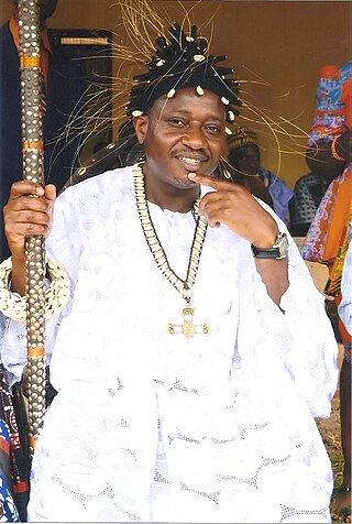
The Fon of Bafut is the fon or Mfor of the town of Bafut and its adjoining areas in the Northwest Province, Cameroon, which comprise the erstwhile Fondom of Bafut. At present, the Fon of Bafut is still a local ruler, but under the jurisdiction of the Government of Cameroon, and a board of Fons. Bafut is one of the largest villages in the North West Province.
Founded in 1800, the Kom are one of the 250 ethnic groups that are located in the grasslands of Cameroon within the Boyo Division of Africa. Kom includes most of Boyo division, including such towns as Fundong, Belo, Njinikom and Mbingo. The area can be reached from Bamenda on the so-called Ring Road.

Bana is a sub-prefecture and commune in the West Province of Cameroon, some 8 km east of Bafang and 2 km south-west of Babouantou.

The Tikar is an umbrella term for a group of closely related peoples who mostly inhabit the Northwest Region of Cameroon with a very small minority in the Adamawa Region. Some of these groups include but are not limited to Bafut, Nso, Kom, Nkwen, and the smaller Tikar people found in the Adamawa Region. They are known to be great artists, artisans and storytellers. Once a nomadic people, some oral traditions trace the origin of the Tikar people to the Nile River Valley in present-day Sudan. According to the Bamenda City Council the Tikari groups migrated from Northern Nigeria to settle in the highlands of western Cameroon. Such ethnic groups were referred to in the 1969 official statistics as "Semi-Bantus" and "Sudanese Negroes." They speak a Northern Bantoid language called Tikar. One of the few African ethnic groups to practice a monotheistic traditional religion, the Tikar refer to God the Creator by the name Nyuy. They also have an extensive spiritual system of ancestral reverence.

Cameroon is home to at least 250 languages, with some accounts reporting around 600. These include 55 Afro-Asiatic languages, two Nilo-Saharan languages, four Ubangian languages, and 169 Niger–Congo languages. This latter group comprises one Senegambian language (Fulfulde), 28 Adamawa languages, and 142 Benue–Congo languages . French and English are official languages, a heritage of Cameroon's colonial past as a colony of both France and the United Kingdom from 1916 to 1961. Eight out of the ten regions of Cameroon are primarily francophone and two are anglophone. The official percentage of French and English speakers by the Presidency of Cameroon is estimated to be 70% and 30% respectively.
The Rumpi Hills Wildlife Reserve is a reserve in the Rumpi Hills in western Cameroon. This site is 452 square kilometres (175 sq mi) in area.
Beba is a Fondom with several village communities that form part of the Benakuma sub-division in the Menchum Valley of the Northwest region of Cameroon. It is about 208 miles (335 km) from the capital city, Yaoundé. The village is accessible by a motorable road while footpaths are used to join distinct communities). Beba Fondom residents claim that their people originated from Widikum in Momo Division. They moved to Bamenda's Ntarinkon Quarter, then Mbengwi Village, later migrated to Ntamecheh and finally settled at their present location.
Guneku is one of the villages in Momo Division located in the Northwest region of Cameroon, Central Africa. It has a tropical climate with 2 main seasons; the rainy and dry seasons with a population of approximately 15 000 inhabitants. The main occupations of the inhabitants are subsistence farming, and cattle rearing. Guneku has a lot of touristic sites such as the palace, caves, mountains, waterfalls, hills and valleys, rivers and springs. Guneku is one of the 31 communities that make up the Meta clan sharing boundaries with Mbemi, Nyen, Tugi, Zang-Tembeng, Oshie, Mundum and Bafut. The Bantous and Mbororos are the two tribes that cohabit peacefully in the community.
Bamunka is a small village of Cameroon located in the North West Region along the ring road from Bamenda. Bamunka Village is the Sub Divisional Headquarter of Ndop Central Subdivision and the Divisional Headquarter of Ngoketunjia Division.

Bambalang is a village located in the NorthWest Region of Cameroon. The village of Bambalang is one of the four villages that make up Ndop Central Sub Division and one of the thirteen villages that make up Ngoketunjia Division. Bambalang village saw most of its fertile land flooded upon the completion of the Bamendjin Dam in 1974 giving rise to some Islands like Mbissa, Nkeshie, Mbefekhu, Mishie and Mpayah. The Bamendjin Dam was constructed mainly to serve as a reservoir to feed the hydroelectric plant at Edéa. It was constructed across the Noun River, a tributary of the Sanaga River that operates the hydroelectric plant at Edea. The construction of this dam has served as a source of mixed feelings for Bambalang people because while those whose fertile land were flooded look at it as a mishap, it is beneficial to a cross section of the population given that it is contributing enormously to the economy of the village with thousands of fishermen whose lives and that of their families depend on fish gotten from the water. The vegetation is Guinea Savanna as farming has destroyed most forests with the exception of the "Pa’ah Ngwong" Forest at the heart of the village. Bambalang village is mainly a hillock stretching in a North West, South-East direction. It is narrow at the North-West and broadens towards the South East, appearing as a semi-Island or a promontory. Bambalang has a length of about 21 km and a width of about 8 km giving an area of about 168 km2 supporting a population of 20.863 people.

Balikumbat is a village located in Balikumbat Sub Division, Ngoketunjia Division of the North West Region, Cameroon. Balikumbat is the Sub Divisional Headquarter of Balikumbat Sub Division and located about 20.9 km from Ndop town.
Bamali village is one of the four villages that make up Ndop Central sub division and one of the thirteen villages of Ngoketunjia division of the North West region of Cameroon. Bamali village is located partly along the ring road from Bamenda some 40 km away from Bamenda town on the Bamenda-Nkambe stretch of the ring road just before reaching Bamunka.
Baba I village (Papiakum) is one of the four villages that make up Babessi subdivision and one of the thirteen villages of Ngoketunjia division of the North West region of Cameroon. Baba I village is located along the ring road from Bamenda some 58 km away from Bamenda town on the Bamenda-Nkambe stretch of the ring road just before one reaches Babessi town.
Bafanji is one of the five villages of Balikumbat subdivision and one of the thirteen villages of Ngo-Ketunjia department in Cameroon. Bafanji is one of five Mangeh villages without a defined boundary.
This is a timeline of the Anglophone Crisis during 2020.
This is a timeline of the Anglophone Crisis during 2021.
Clement Mbashie, better known by his nom de guerre "General No Pity", is an Ambazonian separatist who commands several militant groups, most importantly the Bambalang Marine Forces and Bui Unity Warriors, in the Anglophone Crisis.
