This article does not cite any sources . (July 2013) (Learn how and when to remove this template message) |
Bangert | |
---|---|
Village | |
Coordinates: 52°44′9.72″N5°10′41.1″E / 52.7360333°N 5.178083°E Coordinates: 52°44′9.72″N5°10′41.1″E / 52.7360333°N 5.178083°E | |
Country | |
Province | North Holland |
Municipality | Medemblik |
Population (2007) | |
• Total | 1,430 |
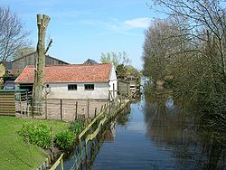
Bangert is a village in northwest Netherlands, located in Medemblik, North Holland. It covers an area of 6.07 km² and had a population of 1430 in 2007.
The Netherlands is a country located mainly in Northwestern Europe. The European portion of the Netherlands consists of twelve separate provinces that border Germany to the east, Belgium to the south, and the North Sea to the northwest, with maritime borders in the North Sea with Belgium, Germany and the United Kingdom. Together with three island territories in the Caribbean Sea—Bonaire, Sint Eustatius and Saba— it forms a constituent country of the Kingdom of the Netherlands. The official language is Dutch, but a secondary official language in the province of Friesland is West Frisian.
Medemblik is a municipality and a town in the Netherlands, in the province of North Holland and the region of West-Frisia. It lies immediately south of the polder and former municipality of Wieringermeer.
North Holland is a province of the Netherlands located in the northwestern part of the country. It is situated on the North Sea, north of South Holland and Utrecht, and west of Friesland and Flevoland. In 2015, it had a population of 2,762,163 and a total area of 2,670 km2 (1,030 sq mi).
Throughout its history Bangert has been competing with surrounding municipalities (esp. Andijk and Kerkbuurt) for land and population. For instance, in 1667 neighboring Kerkbuurt acquired a church and began pulling away some of Bangert's inhabitants. In the 19th and 20th centuries, poverty combined with landgrabbing by Wervershoof also diminished the village. In 2011, Bangert was incorporated in the Medemblik municipality.
Andijk
Drechterland is a municipality in the Netherlands, in the province of North Holland and the region of West-Frisia. The municipality was formed in 1979, in a merger of the former municipalities of Hoogkarspel, Westwoud en Oosterblokker. Its original name, Bangert, was changed to "Drechterland" in 1980. In 2006, the former municipality of Venhuizen was added to Drechterland.
Enkhuizen [ɛŋkˈɦœy̯zə(n)] (
Harenkarspel is a former municipality in the Netherlands, in the province of North Holland and the region of West-Frisia. The main town of Harenkarspel was Tuitjenhorn. In 2013, Harenkarspel merged with Schagen and Zijpe into a new municipality, which is called Schagen.
Hoorn [ˈɦoːr(ə)n] (
Oostzaan is a municipality and a town in the Zaanstreek, Netherlands, in the province of North Holland. The municipality had a population of 9,705 in 2017. Oostzaan has a total area of 16.08 km2 (6.21 sq mi) of which 4.55 km2 (1.76 sq mi) is water.
Wognum is a former municipality and a town in the Netherlands, in the province of North Holland. Wognum received city rights in 1392 but lost them in 1426. In 2007 it merged with the municipalities of Medemblik and Noorder-Koggenland into the surviving municipality of Medemblik.
Champ is a village in St. Louis County, Missouri, United States. The population was 13 at the 2010 census.
Hoogkarspel is a village in the municipality Drechterland, located in the north west of the Netherlands, in the province of North Holland and the region of West-Frisia. The name derives from the words hoog and kerspel, a Middle Dutch word for parish.
Opperdoes is an old village in the Dutch province of North Holland. It is a part of the municipality of Medemblik, and lies about 12 km north of Hoorn. It has a certain fame for its local variety of potatoes, "Opperdoezer Ronde".
Twisk is a village in the Dutch province of North Holland. It is a part of the municipality of Medemblik, and lies about 10 km north of Hoorn.
Midwoud is a village in the Dutch province of North Holland. It is a part of the municipality of Medemblik, and lies about 7 km north of Hoorn.
Hauwert is a town in the Dutch province of North Holland. It is a part of the municipality of Medemblik, and lies about 7 km north of Hoorn.
Oostwoud is a town in the Dutch province of North Holland. It is a part of the municipality of Medemblik, and lies about 8 km north of Hoorn.
Sijbekarspel is a village in the Dutch province of North Holland. It is a part of the municipality of Medemblik, and lies about 10 km northwest of Hoorn.
Lambertschaag is a town in the Dutch province of North Holland. It is a part of the municipality of Medemblik, and lies about 12 km north of Hoorn.
Nibbixwoud is a village in the Dutch province of North Holland. It is a part of the municipality of Medemblik, and lies about 5 km north of Hoorn.
The Arumer Zwarte Hoop, meaning "Black Heap of Arum" was an army of peasant rebels and mercenaries in Friesland fighting against the Habsburg authorities from 1515 to 1523. For 4 years they were successful under the former farmer Pier Gerlofs Donia. Led by his Lieutenant Wijerd Jelckama from 1519 they slowly lost ground and were captured and executed in 1523.