
Transport in Bangladesh is dominated by roadways, accounting for the majority of both passenger and cargo traffic due to substantial development efforts since independence. Eight major national highways connect the capital, Dhaka, with divisional and district headquarters, port cities, and international routes. Despite this, vehicle usage per capita remains low, with non-motorised modes prevailing. However, Bangladesh's roads are unsafe, having one of the highest road accident fatality rates. They also suffer from high congestion, as well as severe air and noise pollution.

Chittagong, officially Chattogram, is the second-largest city in Bangladesh. Home to the Port of Chittagong, it is the busiest port in Bangladesh and the Bay of Bengal. The city is also known as the business capital of Bangladesh. It is the administrative seat of an eponymous division and district. The city is located on the banks of the Karnaphuli River between the Chittagong Hill Tracts and the Bay of Bengal. The Greater Chittagong Area had a population of more than 140 million in 2022. In 2022, the Chittagong District had a population of approximately 9.2 Million according to a census conducted by Government of Bangladesh. In 2022, the city area had a population of more than 5.6 million. The city is home to many large local businesses and plays an important role in the Bangladeshi economy.

Brahmanbaria District is a district in eastern Bangladesh located in the Chittagong Division. Geographically, it is mostly farmland and is topographically part of the Gangetic Plain. It is bounded by the districts of Kishoreganj and Habiganj to the north, Narsingdi District and Narayanganj to the west, Comilla to the south, and the Indian state of Tripura to the east. It was a part of Comilla District until 15 February 1984.
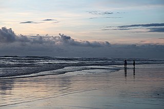
Cox's Bazar is a city, fishing port, tourism centre, and district headquarters in southeastern Bangladesh. Cox's Bazar Beach, one of the most popular tourist attractions in Bangladesh, is the longest uninterrupted naturally occurring sea beach in the world. Located 150 km (93 mi) south of the city of Chittagong, Cox's Bazar is also known by the name Panowa, which translates literally as "yellow flower." An old name was "Palongkee".

Bangladesh Railway is the state-owned rail transport agency of Bangladesh. It operates and maintains all railways in the country, and is overseen by the Directorate General of Bangladesh Railway. The Bangladesh Railway is governed by the Ministry of Railways and the Bangladesh Railway Authority with a reporting mark known as "BR".

Benapole is a town at Sharsha Upazila in the Jessore District of Bangladesh. The Petrapole Customs station of India is situated across the border and since 1947, many people have travelled between Bangladesh and India through Benapole Customs / Land port station. This is one of important rail Transit point of railway link between Bangladesh and India.

Akhaura is an upazila of Brahmanbaria District, a district under Chattogram, Bangladesh. Akhaura Upazila has an area of 99.28 km2. The main river that run through this upazila is the Titas River. Akhaura played an important historical role during both World War II and Liberation War of Bangladesh.

Chunarughat, is an Upazila of Habiganj District in the Division of Sylhet, Bangladesh.
Habiganj Sadar (Bengali: হবিগঞ্জ সদর, is an upazila of Habiganj District in the Division of Sylhet, Bangladesh.

Tetulia, historically spelt as Tentulia, is the northernmost region of Bangladesh, constituting an upazila in Panchagarh District of Rangpur Division. Tetulia is geographically the northernmost tip of Bangladesh. Tetulia is notable for its tea. Tetulia is also notable for views of Kangchenjunga, the third highest mountain in the world, from its plains, rivers and tea gardens.

Kawran Bazar, misspelled as Karwan Bazar, is a central business district and is one of the biggest commodity marketplaces in Dhaka city, the capital of Bangladesh. Located in Tejgaon Thana, it is a designated commercial area of the Dhaka North City Corporation. The biggest local Bangladeshi fruits wholesale market is located here. Kawran Bazar is next to Panthapath, a road that has several well-known establishments.
The Tongi–Bhairab–Akhaura line is a railway line connecting Tongi and Akhaura, via Bhairab Bazar in Bangladesh. There is a branch line from Bhairab Bazar to Mymensingh via Gouripur. These tracks are under the jurisdiction of Bangladesh Railway.
The N1 or Dhaka–কুমিল্লা–Chittagong Highway is the main transportation artery of Bangladesh, connecting the capital city of Dhaka and the southern port city of Chittagong. Approximately 465 kilometres in length, the highway starts at Jatrabari in Dhaka and ends at Teknaf in Cox's Bazar. The highway is known along certain stretches as the Chittagong–Cox's Bazar Highway and the Cox's Bazar–Teknaf Highway.
Benapole Land Port, is the largest land port of Bangladesh located in Benapole town of Sharsha Upazila in the Jessore District. This port is used to export-import good with India through Benapole-Petrapole border. This port is governed by Bangladesh Land Port Authority. About 90% of the imported Indian goods enter Bangladesh through this port.

The Benapole Border Crossing also known as the Petrapole Crossing is an international border crossing between Benapole, Jessore, Bangladesh, and Petrapole, North 24 Parganas, West Bengal, India.
Akhaura Land Port is a major port in Eastern Bangladesh. It is important for international Trade with Northeast India. The Indian side of the port is also known as Agartala Land port.
Bangladesh has total sixteen border-crossings or landports. All of them are with India.

The Burimari Land Port, operated under the management of the Bangladesh Land Port Authority, is one of the major land ports of the country. It is located in the Rangpur Division in the district of Lalmonirhat, within the Patgram Upazila area. On the other side of the border is the Changrabandha land customs station (LCS) in the Mekhliganj subdivision of West Bengal, India.