
Kurigram District is a district of Bangladesh in the Rangpur Division. The district is located in northern Bangladesh along the country's border with India. Under British rule, the area was organized as a mahakuma and was not established as a district until 1984.

Lalmonirhat District is a District, situated at the northern border of Bangladesh. It is a part of the Rangpur Division. Lalmonirhat mahakuma was established as a district on 1 February 1984. To the north of Lalmonirhat lie Cooch Behar and Jalpaiguri districts of West Bengal; to the south lies Rangpur, to the east lie Kurigram and Cooch Behar; and to the west of lie Rangpur and Nilphamari District. The international border line of Lalmonirhat district is 281.6 km long.

North Bengal or Uttar Banga is a term used for the north-western part of Bangladesh and northern part of West Bengal. The Bangladesh part denotes the Rajshahi Division and Rangpur Division. Generally, it is the area lying west of Jamuna River and north of Padma River and includes the Barind Tract. The West Bengal part denotes Jalpaiguri Division and the Malda division together. The Bihar parts include the Kishanganj district. It also includes parts of Darjeeling Hills. Traditionally, the Ganga River divides Bengal into South Bengal and North Bengal, divided again into Terai and Dooars regions.

Bangladesh Railway is the state-owned rail transport agency of Bangladesh. It operates and maintains all railways in the country, and is overseen by the Directorate General of Bangladesh Railway. The Bangladesh Railway is governed by the Ministry of Railways and the Bangladesh Railway Authority with a reporting mark known as "BR".

Benapole is a town at Sharsha Upazila in the Jessore District of Bangladesh. The Petrapole Customs station of India is situated across the border and since 1947, many people have travelled between Bangladesh and India through Benapole Customs / Land port station. This is one of important rail Transit point of railway link between Bangladesh and India.
Patgram is an upazila of Lalmonirhat District in Rangpur Division, Bangladesh. It had 27 enclaves, most notably Dahagram–Angarpota which is connected to the Bangladeshi mainland through the Tin Bigha Corridor.
Hili is a village in Hili CD Block in Balurghat subdivision of Dakshin Dinajpur district in the Indian state of West Bengal. It is a border checkpoint on the India-Bangladesh border.

Rangpur Division is a first-level administrative division of Bangladesh. It covers the northernmost part of the country with a population of about 18 million inhabitants within an area of 16,184.99 km2 (6,249.06 sq mi). Rangpur Division shares border with the Rajshahi and Mymensingh divisions. It is also bordered by the Indian states of West Bengal, Assam and Meghalaya and separated from Bhutan and Nepal by the Siliguri Corridor, and from China by the Indian state of Sikkim. Rangpur City is the administrative headquarter and the largest city. Rangpur Division includes the Teesta and Jamuna rivers.
Banglabandha is a major inland port in northern Bangladesh established to provide a trade link with India, Nepal and Bhutan. The three nations are separated by 52 km (32 mi) of Indian territory, known as the Siliguri Corridor. On the Indian side of the border is Phulbari. Border crossing of vehicles between Phulbari and Banglabandha was inaugurated in January 2011.
Changrabandha is a railway station serving the town of Changrabandha in Mekhliganj CD block, Cooch Behar district in the Indian state of West Bengal.

Burimari is a border railway station in Bangladesh, situated in Lalmonirhat District, in Rangpur Division. It is a land border crossing point and a defunct railway transit point on the Bangladesh-India border. The corresponding point on the Indian side is Changrabandha in Cooch Behar district.
New Gitaldaha railway station is on the broad-gauge Alipurduar–Bamanhat branch line.
Changrabandha is a census town and a gram panchayat in Mekhliganj CD block in Mekhliganj subdivision of Cooch Behar district in the state of West Bengal, India. It is a border checkpoint on the Bangladesh-India border.
Lalmonirhat-1 is a constituency represented in the Jatiya Sangsad of Bangladesh. Since 6 August 2024 The constituency is vacant.
Mahadipur is a village in English Bazar CD block in Malda Sadar subdivision of Malda district in the state of West Bengal, India and is a border checkpoint, on the Indian side of the Bangladesh-India border, with Sonamosjid in Chapai Nawabganj District on the Bangladesh side.
Benapole Land Port, is the largest land port of Bangladesh located in Benapole town of Sharsha Upazila in the Jessore District. This port is used to export-import good with India through Benapole-Petrapole border. This port is governed by Bangladesh Land Port Authority. About 90% of the imported Indian goods enter Bangladesh through this port.
Sonahat is an inland port in the Bhurungamari Upazila in the Kurigram District of the Rangpur Division in Bangladesh.

The Benapole Border Crossing also known as the Petrapole Crossing is an international border crossing between Benapole, Jessore, Bangladesh, and Petrapole, North 24 Parganas, West Bengal, India.
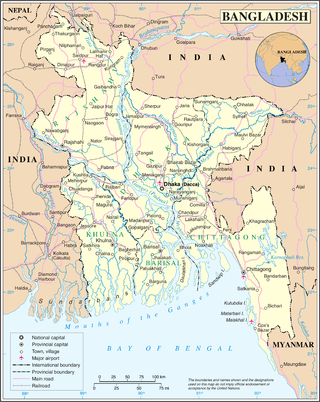
Bangladesh has total sixteen border-crossings or landports. All of them are with India.


